Tropical Seasoning
Introduction
Everyone knows about the seasons. There are four: Winter, Spring, Summer, and Fall. But not everyone knows that the seasonal changes of cold and hot are only in the middle latitudes of the earth. The polar regions have seasons of light and dark, but stay cold, and the tropics have seasons of wet and dry, but stay warm. You thought there were no seasons in the tropics? There are, but they have more to do with wet/dry conditions and wind shifts than with temperature changes or the angle of the sun.
In fact, the tropics (from the equator, at 0 degrees latitude, to the subtropics, at about 30 degrees latitude south and north of the equator) are defined by the fact that they lie no more than 10 degrees at any time from directly underneath the sun's zenith (point directly overhead). This intense solar heating is the main catalyst of the general circulation of the atmosphere. The circulation of the tropics occurs in two cells of closed circulation, one in each hemisphere. These cells are called Hadley Cells, named for George Hadley, who in the 1730s set out to devise a theory that would explain the Trade Winds moving westward along the equator (which is against the earth's direction of spin).
Okay, so what is this circulation all about, and what are these cells? Well, general circulation is the pattern of winds and vertical currents of air around the globe averaged with time, meaning that global patterns continuously mix and balance the air currents over time. The Hadley Cells are a piece of this overall circulation that distribute winds as well as heat and moisture from the equator to the subtropics and back. How does this relate to the seasons? It sends warm air poleward and brings cooler air equatorward, to help with heat distribution. It sends moist air poleward and brings drier air equatorward to help with moisture distribution. And it sends upper-level winds poleward (the westerly Jet Stream) and brings surface winds equatorward (easterly Trade Winds). But that's just to equalize the atmosphere - I'll get to the effects on seasons in a bit.
Hadley Cell Structure
The Hadley Cells in both hemispheres are structured the same. The only differences are a) the motion of winds around high pressure systems, and b) the convergence of winds toward the equator, and divergence of air toward the poles. We'll get to these explanations as we break down the components, but first let's introduce them.
The Hadley Cells are the closed circulations of winds, moisture and heat that keeps the monotonous tropical weather persistent. They complete a full circle, beginning with the Inter Tropical Convergence Zone (ITCZ) near the equator, where rising air (ascending branch) fans out horizontally at the top of the cumulonimbus clouds (showers and thunderstorms) and moves poleward (upper branch). This air gets caught in a westerly flow with the earth's momentum and spirals around the globe in the Subtropical Jet Stream until it eventually loses all its moisture and sinks (sinking branch) into the Subtropical High Pressure areas. It then spirals around the Highs until it shoots off toward the equator as the Trade Winds (return flow), where it converges at the surface of the ITCZ, bringing warm, moist air to rise and form storms again.
Now we have all the components of a Hadley Cell. We have a general overview of how they interrelate. But how do they work, and what makes them do what they do? And what does all of that have to do with tropical seasons? Looking at the components individually may help to ferret out this connection.
Hadley Cell Components
Hadley Cells are comprised of several interrelated pieces that all feed off of each other in order to exist. This creates a nice balance, as Nature intended. We can begin at the equator with the Inter Tropical Convergence Zone (ITCZ), which is the band of low pressure and precipitation that spans near the equator. I say near because it doesn't fall exactly on the equator everywhere around the globe due to differences in land and sea temperatures and terrain. This band of low pressure and precipitation is formed by the convergence of the Trade Winds at the surface. The Trade Winds bring air moistened by traveling over the ocean from 30 degrees N or S latitude, and this air rises and forms convective clouds and rain. Some of this rising air rises all the way to the top of the thundercloud and hits the ceiling at the tropopause (the boundary layer that marks the transition between the troposphere and the stratosphere, and its stability puts a lid on the rising air currents). The air then is funneled either north or south at this boundary, creating the anvils we see in thunderstorms, and heads out of the cloud and toward the poles. At about latitude 30 S and N, this air has cooled and dried out, and begins to converge and sink. As it sinks, it's compressed and thus gets warmer, forming a high pressure area that is not conducive to the formation of clouds or rain. These dry areas of high pressure are called the Subtropical High Pressure areas, and can be seen in a belt at this latitude around the globe. Circulation of winds around the Subtropical High Pressure areas feeds the Trade Winds, which branch off the highs toward the equator at the surface. The momentum of the earth's spin deflects these winds from directly north/south to a westward motion, making them converge at the equator and head west. One note: As the poleward-moving air converges at 30S/30N latitude, remember it had risen to the top of the thundercloud and so is at a high level of the atmosphere. When this air converges, it gets caught in the earth's spin and heads in a spiral around the globe a time or two before settling in to sink into the high pressure areas. This spiraling upper-level air is called the Jet Stream, and these winds blow from west to east.
Piece by Piece
First we'll look at the Inter Tropical Convergence Zone (ITCZ), which is the area where the Trade Winds from both hemispheres converge near the equator. This convergence of surface-level winds and the maximum heating from the Thermal (Heat) Equator (a zone of maximum heating due to surplus solar energy - this zone marks the mean annual location of the ITCZ), combine to provide an environment for thunderstorms to develop. Remember, these develop when warm, moist air rises and cools, developing convection (clouds) which develops into towering thunderheads with the continual rising warm air and moisture. These are known in the tropics as Hot Towers (tall, tropical cumulonimbus clouds). The rising air bumps into the tropopause (stable layer of atmosphere between the troposphere and the stratosphere) and heads poleward north or south, forming the anvils of these thunderheads.
So, back to the ITCZ. This band of converging winds spans the globe in a belt of low pressure and precipitation. The middle of this zone is called the Doldrums because the winds are light and the environment is rainy. The reason the winds are light in this area is because there is no horizontal motion of winds bringing warm or cool air, called prevailing winds. A state of low spirits is known as the doldrums because this area would give sailors many days of no wind when they depended on the wind to fill their sails. That, and the isolation in the muggy heat and rain, was considered most depressing.
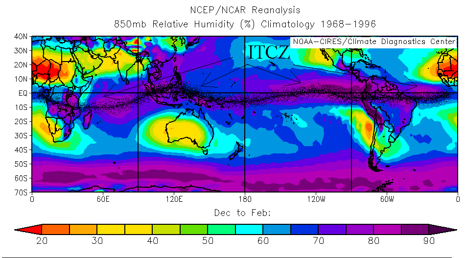
I chose to use two charts to show the location of the ITCZ. The first is Relative Humidity, which indicates the amount of moisture in the air. You can see by the first chart below that the belt of high relative humidity near the equator matches the moisture content of convective thunderstorms noted for the ITCZ. In the second chart below, the surface precipitation rate also verifies the existence of the ITCZ as a belt of rainy conditions near the equator. I used a black spray paint feature to call attention to the band of ITCZ on both charts. In this way, you can see how the ITCZ is connected like a necklace around the low latitudes.
 |
|
Relative Humidity at approximately 35,000 feet for December-February (summer), courtesy of the National Center for Environmental Protection/Monthly Seasonal Climate Composites web page http://www.cdc.noaa.gov/cgi-bin/Composites/printpage.pl. The arrows point to the Inter-Tropical Convergence Zone (ITCZ), indicated by the black spray band. The ITCZ is the band of low pressure and precipitation that flows around the equator, marking the convergence of the Trade Winds from both hemispheres. |
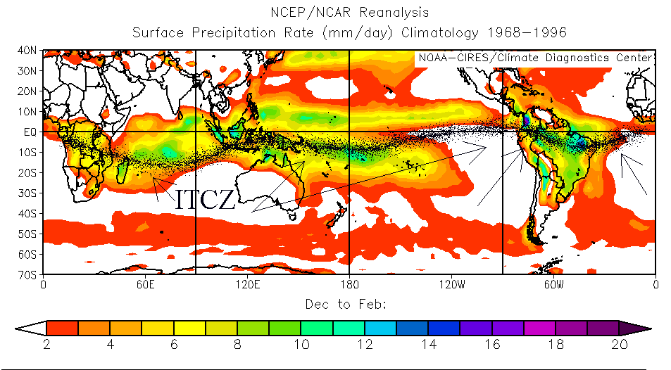
On the second chart, note the higher rates of precipitation over the oceans, then over the continent of South America. There is not much seasonal shift over South America where the heavier precipitation is shown, thus the warm humid air continues rising, bringing constant convection and rain activity. Not surprisingly, this area is where the Amazon Rain Forest is located.
 |
|
Surface Precipitation Rate for December-February (summer), courtesy of the National Center for Environmental Protection/Monthly Seasonal Climate Composites web page http://www.cdc.noaa.gov/cgi-bin/Composites/printpage.pl. The arrows point to the areas of actual precipitation, as indicated by the black spray band, which match the Relative Humidity in the ITCZ chart. |
Next, let's focus back on that rising air bumping up to the tropopause and moving poleward past the anvil. That air is now at a high level of the atmosphere, and as it leaves the ITCZ, it gets caught in the earth's spin and travels eastward in a spiral around the globe for a couple of rotations. These winds speed up and become a major player in the steering of weather systems in both hemispheres - this is our Subtropical Jet Stream.
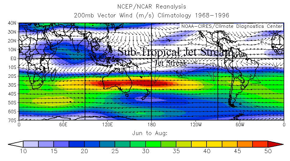
Here's a graphic illustrating the Jet Stream in the Southern Hemisphere winter.
 |
|
Upper-level winds at approximately 40,000 feet for June-August (winter), courtesy of the National Center for Environmental Protection /Monthly Seasonal Climate Composites web page http://www.cdc.noaa.gov/cgi-bin/Composites/printpage.pl. The arrows indicate the Sub-Tropical Jet Stream in the 30S-40S latitude area in the Southern Hemisphere. Note the arrow pointing to the red Jet Streak, which is an area of very fast wind speeds that travels along the Jet Stream. |
In the chart above, you can see the Jet Stream running along the subtropical 30S latitude area, with wind speeds higher than the surrounding air currents. Wind speeds are denoted in colors, and I've also pointed out the Jet Streak in red, which is the core of strongest winds that moves within the Jet Stream. These Jet Streaks are key in the formation and growth of mid-latitude storm fronts from the low pressure areas they create (mid-latitude storm fronts and their creation are another subject entirely). Also keep in mind when looking at the above chart that these winds are in the very upper levels of the atmosphere, at approximately 40,000 feet. The areas in white have noticeably lighter winds because their windier portions are most likely residing in the lower levels of the atmosphere.
Back to the ITCZ. During its spiraling time, the air moving poleward is losing its moisture content and cooling, so that the air eventually sinks. Cool, sinking air raises surface pressure and fosters dry conditions. We now have our Subtropical High Pressure areas, which line up in a belt around the globe at approximately 30 degrees S and N latitude. These subtropical highs are semi-permanent because they are sitting over waters cooler than the nearest landmasses, and the sinking air and rising pressure serve to increase stability. Clouds and rain don't form in a stable atmosphere, so the Subtropical Highs remain cloudless and dry, with light winds. The Horse Latitudes are found here - areas of dry and windless ocean where sailors could be stranded for days or weeks with motionless sails. They got their name from the fact that sailors would throw horses overboard in these conditions to conserve drinking water aboard ship. Or they'd eat them, which is less wasteful, I think.
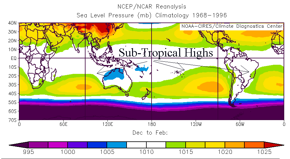
In the chart below, you can readily discern the belt of Subtropical Highs located at around 30S latitude. Also note the pressure levels (in colors) indicating the higher pressure at the orange centers and then lowering pressure ranges surrounding each of the Subtropical Highs. The orange centers represent the Horse Latitudes. In addition, by absence of color in the area surrounding the equator, the ITCZ is indicated with its lower pressure level in the area of 1010 mb (this is the average sea level pressure reading in millibars).
 |
|
Sea-level pressure for December-February (summer), courtesy of the National Center for Environmental Protection/Monthly Seasonal Climate Composites web page http://www.cdc.noaa.gov/cgi-bin/Composites/printpage.pl . The arrows indicate the belt of Sub-Tropical High Pressure centers at latitude 30S in the Southern Hemisphere (latitude 30N in the Northern Hemisphere). |
High pressure areas have an air circulation around their perimeter - clockwise in the Northern Hemisphere and counterclockwise in the Southern Hemisphere. As this once-sinking air diverges at the surface it winds around the high in this spiral of air until it casts off toward the equator as the Trade Winds. It begins to head straight for the equator in a north/south direction (Southern/Northern Hemisphere) then is deflected toward the west by the earth's rotation. The Trade Winds travel at approximately 10-25 mph on the surface of the ocean, thus picking up moisture again as they travel to the equator. In the Northern Hemisphere they travel from the northeast, and in the Southern Hemisphere they travel from the southeast, where they converge at the equator (right at the Doldrums) and travel westward. Before they converge in the Doldrums/ITCZ, they're northeast bearing ensures sailors and merchants of a good breeze by which to gain speed. The area of the Trade Winds also ensures fair weather, with fair-weather cumulus clouds forming from the evaporation of the moistening air (remember, it's moistening by blowing over the water, picking up water vapor from the ocean). This moistened air is what feeds the storm cells in the ITCZ when it converges and rises.
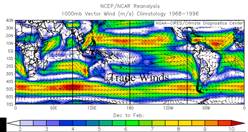 |
| Surface winds for December-February (summer), courtesy of the National Center for Environmental Protection/Monthly Seasonal Climate Composites web page http://www.cdc.noaa.gov/cgi-bin/Composites/printpage.pl . The arrows indicate the southeasterly blowing Trade Winds near the Equator in the Southern Hemisphere (and northeasterly blowing Trades in the Northern Hemisphere). |
The chart above gives a good illustration of the trades converging in a northwesterly direction toward the equator, and blowing due west outside the ITCZ. This chart also shows wind speeds by color, and you can see that the Trade Winds are stronger over the ocean than they are over land. This is due to the friction of the land, partly due to mountainous terrain in places, but mainly due to the fact that winds blow faster over the smooth surfaces of the water than they do over the rough surface of the land. All of the ocean areas on the above chart show faster winds than the land masses, especially over large, uninterrupted expanses of water.
And with that, the Hadley Cell circle is completed. And the question still remains -- how does all of that affect the seasonal wet/dry changes in the tropics?
Seasonal Effects
Now we need to see how all these components of the Hadley Cells, all the give and take of winds, moisture and heat, affect dry and wet seasonal changes in the areas of the tropics. As the seasons change with the proximity of the sun's angle to the hemispheres, solar radiation strengthens in summer and weakens in winter. This strengthening and weakening affects the position of the thermal equator and ITCZ, which follows the surplus energy from the sun's net radiation (the difference in gains and losses of energy). This band of solar heating and convection (rain and storms) moves north of the equator in the Northern Hemisphere's summer (Southern Hemisphere's winter) months, and shifts back south of the equator in the Northern Hemisphere's winter (Southern Hemisphere's summer). The band never goes past the equator, so there is a middle ground that always stays over the tropics. For those areas that stay within this middle band, rain is continual (the Amazon River Basin, for example). For those areas that experience the shifting of the edges of the band either north or south in latitude, the ITCZ band brings a rainy season when it shifts toward them, and a dry season sets in when the band shifts away again (parts of northeast South America fit into this scenario). In summary, the ITCZ shifts with the seasons as the earth circles the sun.
Reflection in the Water
One of the reasons I chose to focus on the seasons is because they fascinate me with their obvious changes in the mid-latitudes. In fact, I moved to the Midwest from Texas because I wanted to experience that fourth season of snow! I couldn't imagine living in the tropics and having no change of seasons, not even if it was considered Paradise. And except for hurricanes, I had always thought the tropics basically had no rain, just endless sunny days. Paradise, maybe - but boring.
Also, I was curious about the Horse Latitudes and where they might be. I watched a move called Visitors a couple of weeks ago about an Australian woman who takes a solo sailing trip around the globe, with the intent to break a record for time. Her only rule was that she couldn't use her engine and she couldn't make contact other than radio with another human during her trip. She did fine until her return, where she encountered the calm, windless seas of the Horse Latitudes. In the movie, she spent several weeks stranded on motionless waters. I'll leave the rest of the plot for those interested in a good Halloween movie.
However, once I learned of the belt of rain near the equator and the seasonal shift of wet/dry weather in some areas of the tropics, and the whole closed circulation idea that balances the winds, heat and moisture, I realized that the tropics weren't boring at all (Paradise notwithstanding). Even the Doldrums hold some excitement, knowing where they are and how they're formed. I like reading accounts of the adventures of ships at sea (especially storms and ghosts) and find it satisfying to know where and what they reference. I also like seeing Nature's balance in play, which kindof makes the world make a little more sense (though this doesn't apply easily to Society, which is terribly unbalanced and therefore, unnatural).
I also found out something about my own study habits. I understood the overall concept and could see the big picture of circulation, of the sending of air out and the return of it as the Trades. But I found I got bogged down in the science, trying to understand the minutiae of which is so important in understanding the whole concept. After writing and rewriting, I learned the concepts better myself by trying to explain them to someone else. Sometimes that's the best way to learn.
All in all, this made me want to charter a ship and sail the open seas, finding and naming everything I'd just discovered!
Debbie Jarvis-Ferguson
Meteo 241 - Assignment #2
Penn State University
October 14, 2005