Tornado Outbreak March 12, 2006 - Updated Information as of 3/16/06
A significant tornado outbreak occurred over portions of eastern Kansas and western Missouri on March 12, 2006. In addition to the fourteen tornado touchdowns detailed below, 201 reports of large hail and/or damaging winds were also received from virtually every county in the Pleasant Hill service area. To put the March 12th outbreak into perspective, an average severe weather season in our local area brings approximately 11 tornadoes, and around 400 reports of hail and/or wind to the local region. Unfortunately, 6 lives were lost from the tornadoes that struck Urich, Sedalia and Renick, Missouri. Another 49 persons were injured.
- 14 Tornadoes - 6 Fatalities - 49 Injuries
Preliminary Tornado Reports March 12, 2006
NOAA National Weather Service personnel conducted ground and aerial damage surveys across portions of western into central Missouri, as well as northeast Kansas, on Monday, March 13th and 14th, in order to assess the strength and number of tornadoes which struck on Sunday. The results of these surveys indicate that at least a total of 14 tornadoes touched down across a large swath of the region. The strongest tornadoes were rated F3 on the Fujita-Pearson damage scale, across portions of central and eastern Saline County, as well as near Renick, Missouri in eastern Randolph county.
The following is a chronological listing of the tornadoes which have been confirmed thus far for March 12th, with the time and location of the initial touchdown and Fujita rating.
Time Location County F-Scale
825 am CST Linwood Leavenworth F0
912 am CST Sibley, Orrick, Henrietta Jackson & Ray F1
950 am CST 2 WSW Carrollton Carroll F0
1046 am CST 1 N Huntsville Randolph F0
227 pm CST Amsterdam Bates F0
350 pm CST 2 NE La Monte Pettis F0
350 pm CST 2 E Calhoun to 5 S of Sedalia Henry, Pettis F2*
to just S of Otterville & Cooper
410 pm CST 3 W Nelson Saline F0
437 pm CST 2 SW Fayette Howard F0
752 pm CST Butler to 4 NNE of Urich Bates & Henry F2*
754 pm CST 3 NE Warrensburg to Johnson, Pettis F2
Arrow Rock and Saline
840 pm CST 2 NE Leeton to just S of Johnson & Pettis F2
La Monte
820 pm CST 4 SSE Marshall to 3 N of Saline & Howard F3
Fayette
910 pm CST 5 SSW Moberly to just S of Randolph F3*
Renick to the county line
* These tornadoes were the ones that resulted in fatalities.
Note the change in Fujita scale rating for the Randolph County tornado, changed after aerial damage survey was completed on March 14. Also, modifications were made to the tornadoes in Saline County, where the tornado thought to have developed just within Howard County actually developed further south and west, just northeast of the US-65 and I-70 interchange. This tornado actually ran parallel about 3 miles southeast of the 754 pm tornado for several miles! A third amendment was made to the 350 pm La Monte tornado, which apparently ended up being a solid track (based on chaser accounts and video footage) from northeast of La Monte to west of Nelson.
These 14 tornadoes were confirmed by damage surveys out of a preliminary count of 32 tornado reports received into the National Weather Service on Sunday. A total of 201 large hail and/or damaging wind reports were also received into the National Weather Service office in Pleasant Hill, from locations across much of western and central Missouri, and adjacent northeast Kansas. Virtually every county of the 44 served by the Pleasant Hill office experienced a severe thunderstorm on Sunday.
The initial round of four tornadoes (shaded in red on the map posted on the Pleasant Hill web site) formed from a supercell thunderstorm that moved through a rather cold and dry airmass at ground level. The temperature at the Kansas City International Airport, at the time of the tornado near Linwood), was in the lower 40s. Much warmer air existed aloft though, that allowed the storm to produce intermittent tornadoes from the northwest side of the Kansas City metro area, east-northeast into central Missouri. The storm also produced extensive hail and wind damage as it cycled, or reorganized, and moved across the Northland. The most intense tornado from supercell storm struck along the Missouri River near Sibley, then tracked east-northeast through Orrick in Ray County. F1 damage was confirmed in this area by an NWS survey team.
The second round of tornadoes (shaded in blue on the map) occurred during the mid-afternoon hours. Further assessment has brought the number of tornadoes from this round of storms down to four, as what was thought to be two brief touchdowns actually ended up being one tornado. The most significant tornado from the afternoon round touched down at approximately 3:50 pm in far eastern Henry County, then moved east-northeast across southern Pettis County and into far southwest Cooper County before dissipating. This tornado produced F2 damage to several structures south and southeast of Sedalia. One of the tornado fatalities occurred with a resident attempting to evacuate a mobile home to the south of Sedalia. The other tornadoes from the second round include a F0 tornado which affected areas from Amsterdam to near Adrian in Bates County. Damage was noted to the Amsterdam Fire Department. A third touchdown was noted by spotters just northeast of La Monte in Pettis County (this would be a second storm north of the one that produced the F2 south of Sedalia). This tornado moved northeast, crossed I-70 and then dissipated west of Nelson in Saline County. Damage from this tornado caused traffic problems along I-70 west of Boonville for a time. A fourth F0 tornado touched down briefly southwest of Fayette in Howard County.
The final round of six tornadoes (shaded in green) struck the region after sunset Sunday evening. These tornadoes also were the most intense of the outbreak, and also the most dangerous as they occured after dark. Two distinct supercell thunderstorms produced this series of tornadoes from Johnson County, Missouri, northeast through Saline, Howard and Randolph Counties.
The first tornado of this round struck near Butler (in Bates County) around 7:52 pm, then moved northeast to areas west and north of Urich in Henry County around 8:10 pm to 8:15 pm. F2 damage was noted north of Urich, and this tornado took the life of a man north of Urich. This tornado dissipated just southeast of Blairstown in northern Henry County. A second tornado formed from this supercell storm approximately three miles northeast of Leeton (in Johnson County, Missouri) around 8:40 pm. The tornado tracked across eastern Johnson County to the south of Whiteman Air Force Base (AFB), then dissipated to the southwest of La Monte in Pettis County. Damage of F2 intensity was noted south of Whiteman AFB, where roofs were completely removed from several frame houses along Y Highway.
The remaining four tornadoes formed from the second supercell storm. The first tornado from this supercell touched down approximately 3 miles northeast of Warrensburg around 7:54 pm. The tornado moved northeast, producing F0 damage through northeast Johnson and northwest Pettis Counties. The tornado may have lifted briefly south of Sweet Springs, but damage increased again along this same path approximately 3 miles southeast of Sweet Springs. The tornado intensified near I-70, and produced F2 damage just northeast of I-70 near Exit 71, where several houses lost their roofs. Further strengthening occurred as the tornado passed south of Marshall where the tornado intensified to F3 strength.
As this tornado passed south of Marshall along US-65, a second tornado formed approximately 3 miles south-southeast of the first tornado. Both were visible from the I-70 and US-65 interchange. Both tornadoes moved northeast and paralleled each other for several miles! A third tornado in Saline County formed briefly as the first two approached the Missouri River. Storm chaser accounts describe this third tornado as short-lived, as it quickly merged with the second tornado (similar to what occurred on March 13, 1990 east of Hesston, KS) and quickly led ot the second tornado becoming over a quarter mile wide and intensifying to F3 strength, while the first tornado finally occluded and dissipated. The tornado (now just one on the ground) passed north of Arrow Rock and produced F2 damage to the northwest of Fayettte. The last tornado associated with this supercell developed to the south-southwest of Moberly, or just to the east of Higbee, in far southern Randolph County, at approximately 9:10 pm. The tornado moved northeast to just south of Renick, where F2 damage was noted to several homes and mobile homes. This tornado took the lives of four Randolph County residents. The tornado produced F3 damage where a farmhouse was destroyed, just before it moved northeast and into Monroe County. Details on the Monroe County portion of this tornado track can be found on the St. Louis NWS web site.
A preliminary tally of tornado reports received on Sunday across the United States March 12-13 can be found at http://www.spc.noaa.gov/climo. Additional details on the Fujita-Pearson damage scale can be found at http://www.spc.noaa.gov/faq/tornado/f-scale.html.
11-13 MARCH 2006 TORNADO OUTBREAK
During this three day period, three rounds of severe weather occurred. The first round occurred during the early morning hours of March 11th with mostly a hail event that occurred south of Interstate 44 and the St. Louis Metropolitan Area. Hail size ranged from penny to golf ball, with many reports of hail covering the ground. The second round of severe weather occurred during the afternoon and evening hours of March 11th. Round after round of supercell thunderstorms moved across the entire county warning area producing large hail, damaging winds and tornadoes. The third and final round of severe weather stretched from March 12 into the early morning hours of March 13. Several waves of supercell thunderstorms brought large hail, damaging winds, and more tornadoes to Missouri and Illinois.
During this event the St. Louis Weather Forecast Office issued nearly 200 warnings, and received over 150 severe weather reports. Meteorologists spent the following week surveying the tornado damage that stretched to the far reaches of the county warning area to determine the tornado tracks length, width, and strength. Planes also flew over the damage paths collecting pictures and video from above. Over the next two weeks, meteorologists will construct detailed tornado track maps from storm survey information and radar data. As of March 16th there have been 22 confirmed tornado touchdowns from this event across the St. Louis County Warning Area, although further investigation over the coming weeks may determine a few more weak tornado tracks. Below is preliminary information that has been sent via Public Information Statements on the confirmed tornadoes.
CONFIRMED TORNADO INFORMATION
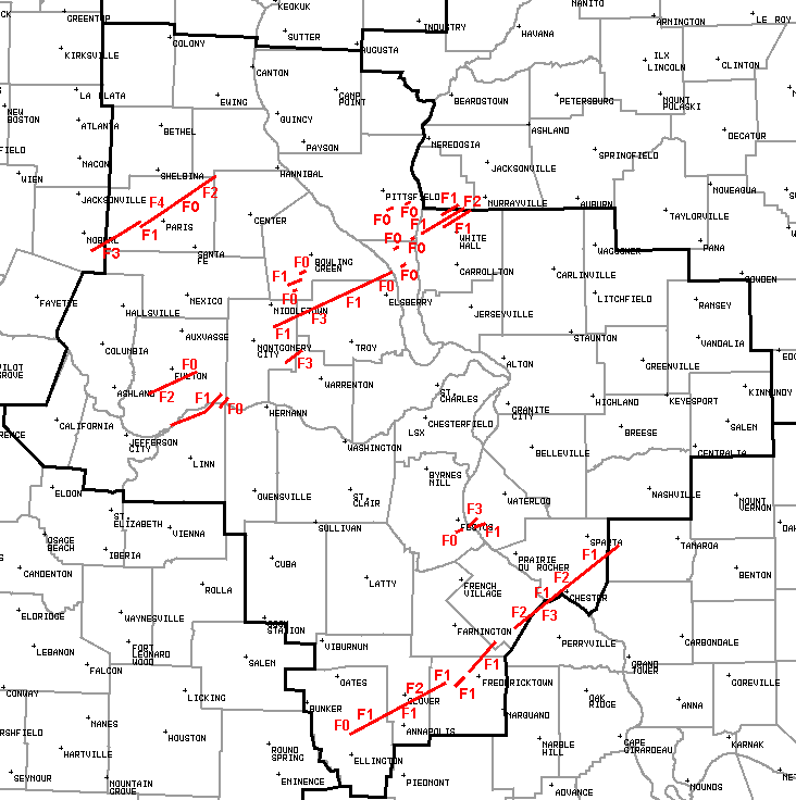
Monroe County, MO (Paris and Monroe CIty Tornado)
Reynolds County, MO to Randolph County, IL (Chloride, Minnith, Chester, and Steelville Tornado)
Montgomery, Lincoln and Pike Counties, MO (Olney and Silex Tornado)
Jefferson County, MO to Monroe County, IL (Festus and Fults Tornado)
Callaway County, MO (Fulton Tornado)
Pike County, MO (New Hartford and Ashley Tornadoes)
Greene County, IL (Hillview and RoodHouse Tornado)
Callaway, Osage, Montgomery and Warren Counties, MO (Jonesburg Tornado)
Pike County, IL (Independence and Milton Tornado)
STORM REPORTS
State of Missouri Tornado Statistics for March 11-12 2006
Preliminary indications are that the F3 tornado damage in Perry County, MO and the F2 damage in
Perry Co. IL were part of a 54-mile long path that began in Ste. Genevieve County, MO.
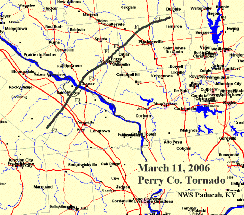
Below is the preliminary damage assessment for the segment of tornado in Perry County, Missouri:
* EVENT DATE: SATURDAY NIGHT MARCH 11TH.
* EVENT TIME: 944 PM CST WAS 1ST REPORT OF 1ST TOUCHDOWN.
* EVENT TYPE: F3 TORNADO (MAX) ON THIS SEGMENT.
* EVENT LOCATION: DAMAGE TRACK ON THIS  SEGMENT IS FROM

                  APPROXIMATELY 6 MILES SOUTH-SOUTHWEST OF SAINT

                  MARYS...NEAR HIGHWAY NN AND JUST WEST OF THE TOWN

                  OF GIBONEY...TO APPROXIMATELY 1 MILE

                  SOUTH-SOUTHEAST OF SAINT MARYS...ENDING CLOSE TO

                  RAILWAY TRACKS JUST NORTH OF COUNTY ROAD 950 BY

                  OLD RIVER.
* PEAK WIND SPEED ON THIS SHORT SEGMENT: 170 MPH
* DAMAGE WIDTH: 350 TO 400 YARDS AVERAGE WIDTH.
* PATH LENGTH: 7.25 MILES.
* INJURIES: AT LEAST 4 PEOPLE ON THIS SHORT SEGMENT WERE KNOWN TO BE

            SIGNIFICANTLY INJURED AS THEY WERE PICKED UP BY TORNADIC

            WINDS AND THROWN 100 YARDS. IN ADDITION THEY WERE ALSO HIT

            HARD BY OTHER THROWN DEBRIS...CUMULATIVELY RESULTING IN

            SIGNIFICANT INJURY TO THEIR PERSONS.
* FATALITIES:  2 KNOWN ON THIS SEGMENT OF THE STORM. 2 FATALITIES WERE

               RESIDENTS OF A MOBILE HOME WHO TRIED TO FLEE SAID

               RESIDENCE...BUT UPON DOING SO GOT IN THEIR CAR.

               THE TORNADO PICKED UP THE CAR AND THREW IT INTO A

               PROPANE TANK...AND BOTH PASSENGERS DIED AS A RESULT.
* DISCUSSION/DAMAGE:  IT MUST BE STRESSED THAT THIS IS ONLY A

PRELIMINARY ASSESSMENT FOR THE SHORT SEGMENT OF THIS TORNADO IN

NORTHERN PERRY COUNTY MISSOURI ONLY. MORE EXTENSIVE ADDITIONAL

ASSESSMENTS FOR THE OVERALL TRACK OF THIS TORNADO WILL BE

FORTHCOMING. IN ADDITION TO THE AFOREMENTIONED REPORT...THREE MOBILE

HOMES WERE ALSO FLATTENED...ONE BRICK HOUSE HAD ITS ROOF AND SEVERAL

WALLS BLOWN OFF...AND NUMEROUS VEHICLES WERE REPORTED TO BE TOSSED

AROUND THE ROAD.
...DAMAGE SURVEY RESULTS FOR SEGMENT OF TORNADO IN ST. LOUIS OFFICE’S AREA...
...DAMAGE SURVEY RESULTS FOR PERRY COUNTY ILLINOIS SEGMENT OF TORNADO...
THE FOLLOWING IS THE PRELIMINARY DAMAGE ASSESSMENT FOR A TORNADO IN

PERRY COUNTY ILLINOIS.
SPECIAL NOTE: THIS TORNADO TRACK IS ONLY A

SEGMENT OF THE TORNADO THAT AFFECTED PARTS OF SOUTHEAST MISSOURI AND

SOUTHERN ILLINOIS.
* EVENT DATE: SATURDAY MARCH 11 2006.
* EVENT TIME: APPROXIMATELY 1140 PM CST.
* EVENT TYPE: F2 TORNADO.
* EVENT LOCATION: 11 MILES WEST OF PINCKNEYVILLE TO 2.5 MILES

  NORTH OF TAMAROA.
* PEAK WIND: 140 MPH.
* AVERAGE PATH WIDTH: 300 YARDS.
* PATH LENGTH: 20 MILES.
* INJURIES: 2.
* FATALITIES: NONE.
* DISCUSSION/DAMAGE: THERE WERE SEVERAL EYEWITNESS ACCOUNTS OF THE

TORNADO. A DOUBLE WIDE MOBILE HOME WAS COMPLETELY DESTROYED AND

DOZENS OF OTHER HOMES WERE SEVERELY DAMAGED. THERE WERE DOZENS OF

BARNS BLOWN DOWN AS WELL AS THOUSANDS OF TREES.
$$
HOOPER/PACKETT
Several supercell thunderstorms spawned tornadoes across the Missouri Ozarks Sunday afternoon and evening, March 12, 2006. Below you can find storm surveys completed by National Weather Service storm survey teams and maps of the tornado tracks.
The National Weather Service in Springfied Missouri very much appreciates the efforts and partnership of all storm spotters, HAM radio operators, emergency management, law enforcement, and media.
...Update
on March 12th 2006 Tornado Surveys...
The National Weather Service in Springfield is continuing to gather data and
conduct storm surveys on the March 12th tornado outbreak. At this time damage
surveys have been conducted on 12 confirmed tornado tracks...with additional
surveys still to be conducted tomorrow to investigate 2 to 3 additional possible
tornado tracks and a continuation of an already confirmed tornado track.
Here are some preliminary statistics on the tornado outbreak...these numbers
will be updated as additional information is gathered. In the National Weather
Service Springfield county warning area:
number of tornados: 12 (including 2
F0`s, 4 F1`s, 3 F2`s, and 3 F3`s)
number of fatalities: 1 (in Lawrence
County)
number of injuries: 36
number of homes destroyed: 202
number of homes damaged: 366 (not
including those destroyed)
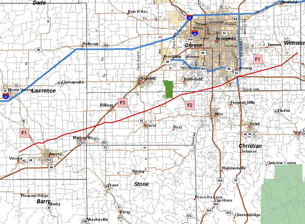
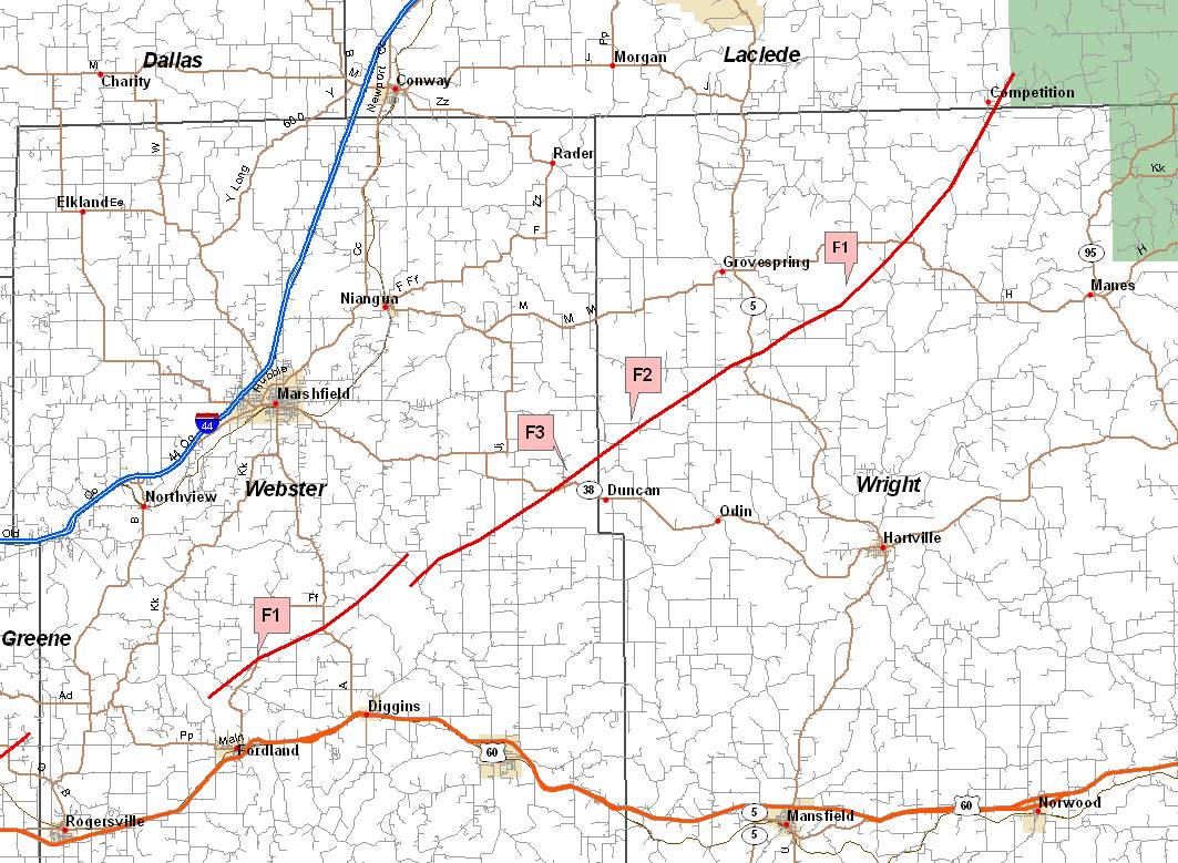
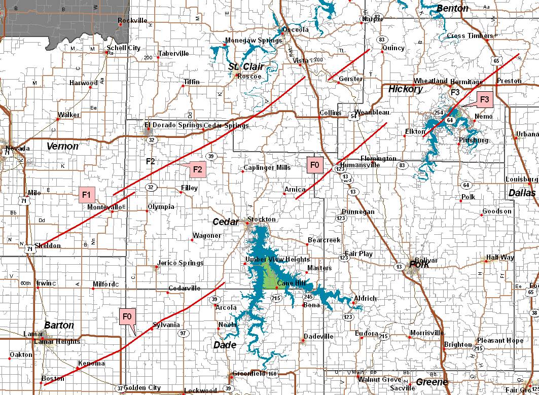
Preliminary Tornado Track Map for the Missouri Ozarks
The tornado
tracks below are preliminary and will be refined as additional information is
obtained. 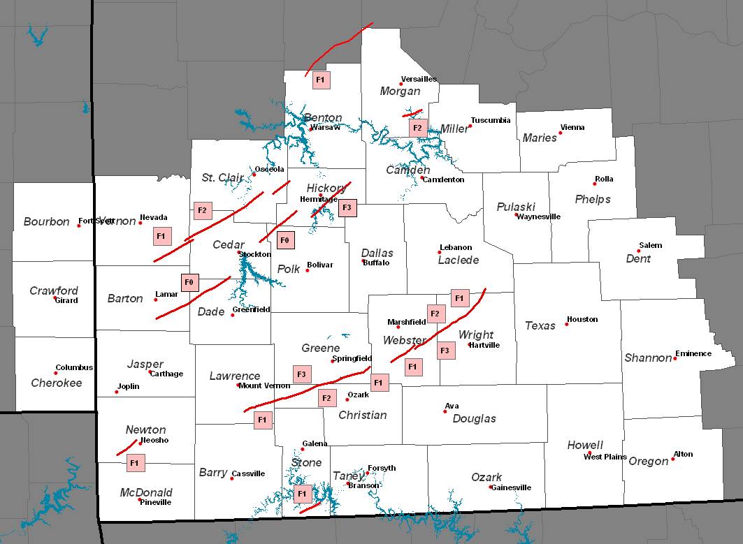
Here is a rundown of the preliminary statistics from for each of the 12 tornado
tracks that have been surveyed:
1) At approximately 400 pm a tornado moved into extreme northwest Benton County
from Henry County before moving back north out of the county and into Pettis
County. The damage in Benton County was rated F1 intensity on the Fujita scale.
The tornado moved into Benton County around 405 pm and moved out of the county
at approximately 410 pm. Total path length in Benton County was about 5 miles
with a maximum width of about 200 yards.
2) At approximately 847 pm the second tornado touch down occurred in southern
Vernon County near the town of Sheldon . This tornado moved northeast across
northwest Cedar County and into south central St. Clair County with damage
tracked to about 3 miles south of Vista in St. Clair County. Additional damage
surveys will be conducted Thursday northeast of this area to determine where
exactly this tornado lifted. This tornado was on the ground for approximately 38
miles with a maximum width of nearly a 1/4 mile. The damage assessment indicates
that the maximum intensity of this tornado was F2 on the Fujita scale just south
of El Dorado Springs.
3) At approximately 855 pm the third tornado touchdown of the day was spawned
from the same supercell which produced tornado number 2. This next tornado was a
brief touched just north of Montevallo and produced F1 intensity damage on the
Fujita scale. This tornado was on the ground for about 1 mile with a maximum
width of around 200 yards.
4) At approximately 918 pm the next tornado to touch down on March 12th was in
Barton county near Boston . There was an intermittent damage track from Barton
county northeast across Dade...Cedar...Polk...and Hickory County. This tornado
was on the ground for approximately 40 miles with a maximum intensity of F0 on
the Fujita scale and a maximum width of approximately 30 yards.
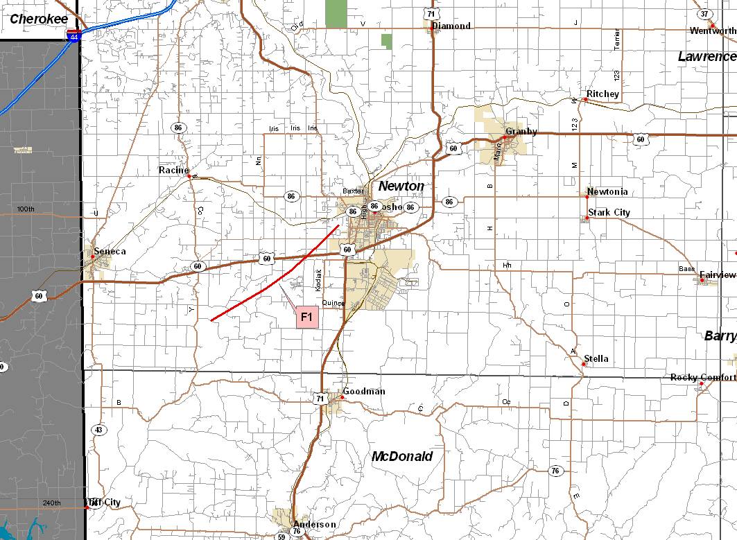
5) At approximately 922 pm the next tornado to touch down was in Newton county.
This tornado touched down approximately 6 miles southeast of Seneca and moved
northeastward lifting 3 miles southwest of Neosho . This tornado was on the
ground for approximately 7 miles with a maximum width of 1/8th of a mile and had
a maximum intensity of F1 on the Fujita scale.
6) At approximately 938 pm the same storm that spawned tornado number 5 in
Newton county went on to produce an additional F0 tornado shortly after the
first tornado lifted. This tornado touched down approximately 1/2 mile west of
Neosho and was on the ground for 1/10th of a mile.
7) The next tornado to touch down was in Lawrence County at approximately 1008
pm and was spawned by the same supercell which produced the tornadoes in Newton
County . This tornado began its path just north of Verona in Lawrence County and
continued east-northeastward through northwestern Christian and southeastern
Greene Counties lifting just west of the Webster Greene County line between a
highway and ad highway. This tornado was on the ground for
approximately 40 miles with a maximum width of 1/2 mile. The most intense damage
with this storm occurred between Nixa and Billings and this tornado was rated
with a maximum intensity of F3 on the Fujita scale.
8) At approximately 1017 pm the next tornado touch down occurred in Hickory
County 5 miles west of Pittsburg and continued on the ground to 3 miles east of
hermitage. This tornado was on the ground for approximately 9 miles and had a
maximum width of 1/4 mile. The maximum intensity of this tornado was F3 on the
Fujita scale.
9) The next tornado to touch down was in Morgan County around 1025 pm
approximately 3 miles southwest of Gravois Mills. This tornado was on the ground
for about 6 miles with a maximum width of approximately 3/8th of a mile. The
maximum intensity of this tornado was rated F2 on the Fujita scale.
10) The next tornado to affect the National Weather Service Springfield’s county
warning area was in southern Stone County at around 1057 pm. The tornado crossed
the state line from Carroll County Arkansas into southern Stone County and
moved into southern Stone County 1 mile east southeast of Carr Lane and
traveled northeastward for 3 miles into Stone County . The path was
approximately 100 yards wide with a maximum intensity of F1.
11) At 1103 pm...the next tornado touched down in Webster County approximately 3
miles northwest of Fordland and continued northeastward for approximately 11
miles lifting north of Diggins. This tornado was rated an F2 intensity on the
fujita scale and had a maximum width of approximately 1/4 mile.
12) The final tornado that has been confirmed so far touched down at
approximately 1120 pm about 5 miles north of Diggins and continued northeastward
into Wright County eventually lifting after crossing into southeast Laclede
County near competition. This tornado was on the ground for approximately 31
miles with a maximum width slightly
larger than 1/2 mile wide. The maximum intensity was rated F3 on the Fujita
scale.
Here is the Fujita scale:
F0: gale tornado (40-72 mph)
F1: moderate tornado (73-122 mph)
F2: significant tornado (113-157 mph)
F3: severe tornado (158-206 mph)
f4: devastating tornado (207-260 mph)
F5: incredible tornado (260-318 mph)
Tthe National Weather Service will be conducting additional surveys of damage in
Ozark...southeast Douglas...Dent...Benton...and eastern St Clair Counties
Thursday. Additional information from these
surveys will likely be available late Thursday or Friday.
National Weather Service Springfield issued 53 Tornado Warnings, 34 Severe Thunderstorm Warnings, and received 59 tornado reports and 68 severe hail and wind reports.
The National Weather Service would like to thank the many people who have helped in the storm survey process.
Anyone with information on damage, video or pictures of damage or the storms are asked to relay that information to the National Weather Service in Springfield. Submit storm reports on our website or use E-Spotter to relay your report. Your report is much appreciated!
Please check back on our website for additional information.
Check out the Storm Prediction Center for preliminary storm reports.
Tornado Tracks Lawrence, Christian and Greene Counties
Tornado Tracks for Webster, Wright and Laclede Counties
Tornado Tracks for Barton, Vernon, Cedar, St. Clair, Hickory, Dade and Polk Counties
Tornado Track for Newton County