George R. Kasica
Project 1: Lessons Learned From My
Forecasting Experiences in the "Weather Station"
During my 12 week class of Meteo 101 it became very obvious that to be
come a better weather forecaster you had to have not only the technical
and "book" knowledge as a foundation, but practical forecasting
experience and the "trail and error" of learning from the times
that your forecasts either verified as expected or didn't verify and then
look at the reasons behind either the success or failure of your
predictions. Below this are several instances from the course that
helped to reinforce the classroom knowledge with real world forecasting
experience:
Forecasting Assignment #1: Identifying locations under IFR Flight
Rules
This assignment was fairly basic in nature, we had to locate and
identify a city that had weather conditions that caused aviators to
have to follow IFR (Instrument Flight Rules) and what the criteria was
for this
08/31/05 0112Z KPWM
METAR text: KPWM 310112Z AUTO 20007KT 5SM BR OVC003 21/19 A2992
RMK AO2 TSNO
Conditions at: KPWM observed 0112 UTC 31 August 2005
Temperature: 21.0°C (70°F)
Dewpoint: 19.0°C (66°F) [RH = 88%]
Pressure (altimeter): 29.92 inches Hg (1013.3 mb)
Winds: from the SSW (200 degrees) at 8 MPH (7 knots; 3.6 m/s)
Visibility: 5 miles (8 km)
Ceiling: 300 feet AGL
Clouds: overcast cloud deck at 300 feet AGL
Weather: BR (mist)
This station qualifies for LIFR (Limited Instrument Flight Rules).
The cieling height at KPWM (Portland Int'l Jetport, Portland Maine) is
300' Above Ground Level which is below the minimum 500' ceiling for
Limited Instrument Flight Rules) though the visibility of 5 miles with
Mist would qualify the station for either Modified Visual Flight Rules
(MVFR range is 3-5 miles) or Visual Flight Rules (VFR over 5 miles).
Reflection: This assignment helped to
reinforce the importance that weather forecasting plays to the
aviation industry and how critical it is that accurate timely
information is received, processed and put into a useable form for
those that require it.
Forecasting Assignment #2: Passage of a Cold Front
This assignment was to locate a city that experienced the passage
of a cold front and indicate by how the atmospheric conditions changed
that the front has indeed passed the location.
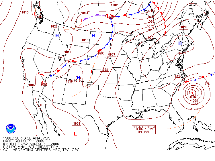
Between 0200 and 0300Z 11 Sept 2005
Rapid City SD
Winds shifted from a WSW Direction to a NW Direction at the time of
frontal passage and the temperature fell sharply from aproximately 85F
at 01Z to near 65F by 03Z. The Dew Point remained relatively constant
at 26F which would indicte the air became much more saturated.
Pressure and cloud cover were also relatively constant at about 1005mb
and clear skies respectively.
There was no precipitation recorded before during or after the passage
of the front.
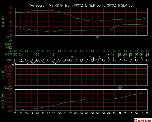
Reflection: This assignment reinforced the lesson
material on how conditions change after the passage of a cold front.
Forecasting Assignment #8: Forecasting precipitation for a European
Location
This assignment was to locate a city in Europe that would
experience precipitation.
00Z Tue 25 Oct 2005
Moscow, Russian Federation Precipitation
UUWW
(There are also 2 other stations located in Moscow Russian Federation
UUDD and UUEE). I will use one of these as alternates if UUWW is not
available at 00Z Tuesday 25 Oct METAR Time)
Conditions at: UUWW observed 0000 UTC
25 October 2005
Temperature: 3.0°C (37°F)
Dewpoint: 1.0°C (34°F) [RH = 87%]
Pressure (altimeter): 29.62 inches Hg (1003.0 mb)
Winds: from the WNW (300 degrees) at 22 MPH (19 knots; 9.9 m/s)
Visibility: 6 or more miles (10+ km)
Ceiling: 1500 feet AGL
Clouds: broken clouds at 1500 feet AGL
Weather: -SHRA (light rain showers)
The forecast map showed preipitation would be falling at UUWW (Moscow)
at 00Z on Oct 25 and this is confirmed by the METAR from 00Z showing
Light Rain Showers, so the forecast verified well with the actual
conditions. In looking back to the previous 6 hours before 00Z it also
showed that on several of the observations that there were
intermittent periods of precipitation throughout that 6 hour period.

Reflection: This assignment showed that
you have to not only be able to forecast for areas you are familiar
with but also places that you have never seen or been to. This is
important to remember because as an operational forecaster you don't
necessarily get to pick the locations you want to forecast for, but
instead have to provide forecasts for any needed location at any given
time with possibly very little advance warning.
Forecasting Assignment #9: Forecasting precipitation at a given time
and location.
This assignment was to forecast precipitation for a given location
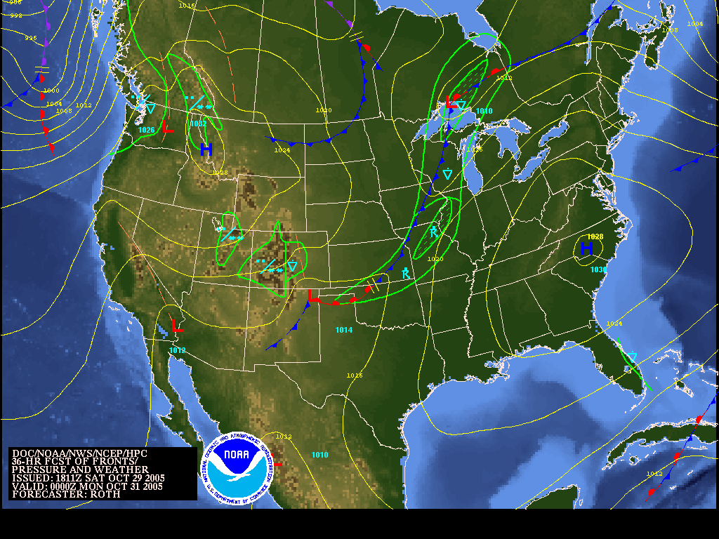
at a specified time.
The low's center is predicted to be located on
the Northern shore of Lake Superior at 00Z on October 31, 2005.
Peoria, IL (KPIA)
Dynamic Lifting Type II
I feel that the process involved in producing precipitation at Peoria,
IL (KPIA) at 00Z 31 October 2005 as shown on the attached image is due
in part to Dynamic Lifting Type II because is is located far from the
low pressure center which is predicted to be over Northern Lake
Superior.
Conditions at: KPIA observed 2354 UTC 30 October 2005
Temperature: 15.6°C (60°F)
Dewpoint: 5.0°C (41°F) [RH = 49%]
Pressure (altimeter): 30.10 inches Hg (1019.4 mb)
[Sea-level pressure: 1019.5 mb]
Winds: from the SSW (200 degrees) at 10 MPH (9 knots; 4.7 m/s)
Visibility: 10 or more miles (16+ km)
Ceiling: 4600 feet AGL
Clouds: broken clouds at 4600 feet AGL
overcast cloud deck at 9000 feet AGL
Weather: no significant weather observed at this time
The model predicted a slight chance of rain showers in the area of
Peoria at the time it was vaild, 00Z, and there was no significant
weather of any sort in many hours prior to and up to the valid time.
In looking at a later observation from 0054Z it is in fact raining
lightly (-RA).
So by definition of the assignment the prediction was not correct as
stated on the graphic, but it did in fact start to rain shotly after
the predicted time of the forecast, another indication that we cannot
blindly accept the output of computer generated forecasts as an exact
statement of what the weather will be at a given time.
Reflection: This assignment showed that the
numerical models are not always perfect in their predictions and that
even though the model indicated there would be precipitation at a
given time at the location, it it not necessarily a guarantee.
Final Comments: During this 12 week course I was
made aware of the many different types of weather forecasting data,
computer models, and other resources available to make a forecast
for a given location at a specified time. I also learned that just because
a computer model indicates that something SHOULD happen is no guarantee
that it WILL happen in reality in the atmosphere and that is the part of
the course that shows where experience with the various computer models
and their shortcomings or quirks helps in forecasting accurately. In any
case however, it is far from an exact science and this is the reason that
I am interested in it. No matter how certain a given situation may appear
there is always the possibility that it may not occur as you predict and
this is the challenge of weather forecasting. |
