| |
| George R. Kasica
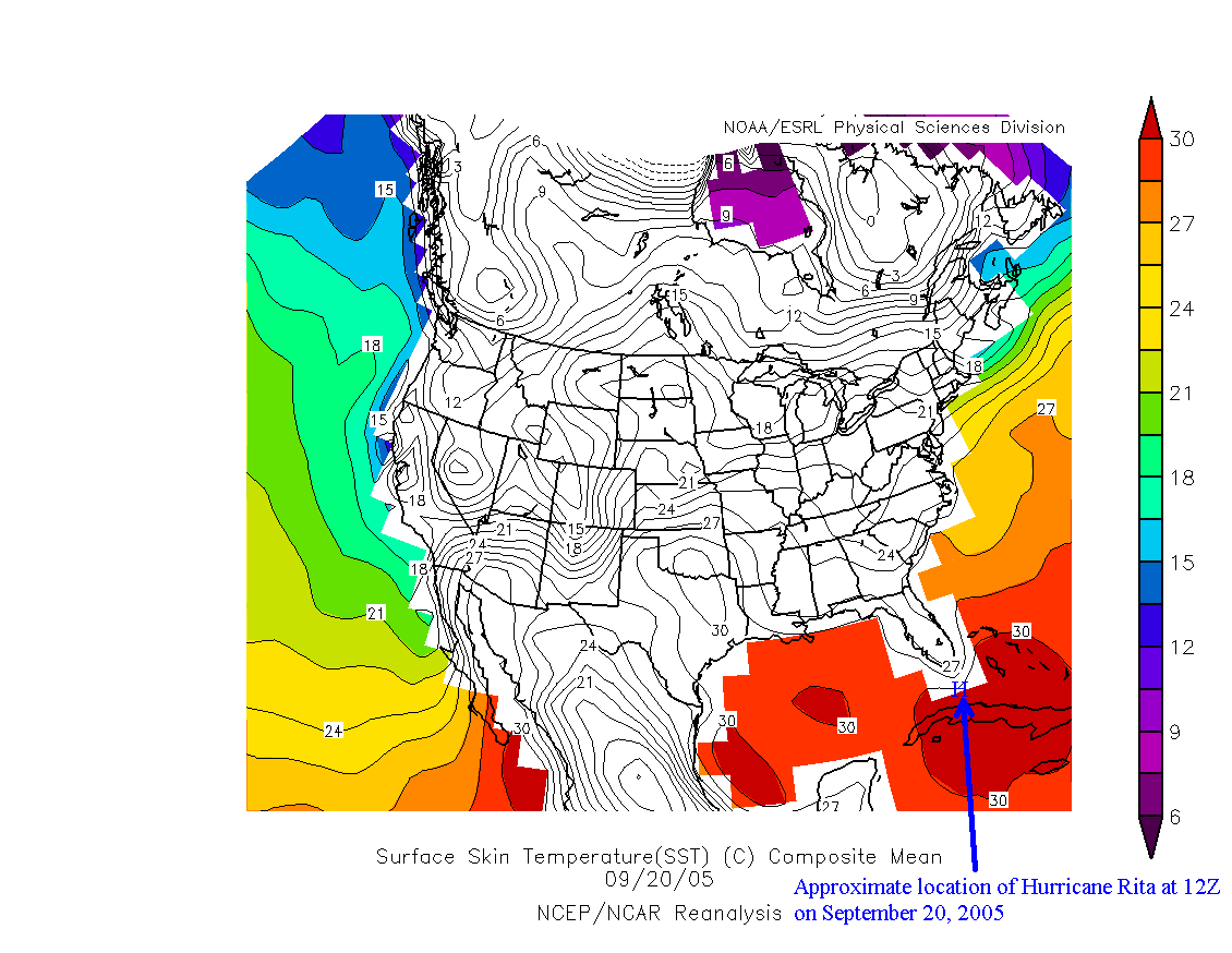
METEO 241 Portfolio #3: Review of the sea-surface temperatures, mid-tropospheric relative humidity and vertical wind shear on September 20, 2005 In this section we are going to look at three very critical atmospheric and oceanic conditions that existed on September 20, 2005 shortly before the storm attained the status of a hurricane. The items we are going to look at will include sea-surface temperature, the relative humidity amount at the 500mb level which is representative of the middle of the troposphere, and the wind shear from the 850-200mb level which is the zone that is most responsible for the strengthening (or lack there of) of a storm into a hurricane. For the first item lets look at the sea surface temperatures on September 20, 2005:
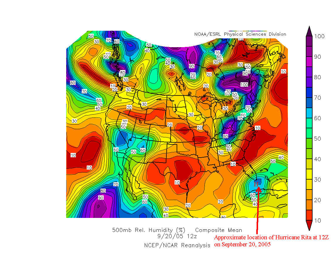
As you can see on the annotated image above the storm was located in an area of very nearly 30C sea surface temperatures. This extremely warm water between Florida and Cuba was able to provide an abundant supply of fuel to the storm in the form of both energy in the form of heat as well as a huge amount of warm moist air to fuel the thunderstorms that make up the storm itself. The second ingredient we can look at for Rita at this time is the relative humidity in the middle of the troposphere (in this case the 500mb level) from the period at 12Z on September 20, 2005:
Looking at the above image we can clearly see the atmosphere in the area of hurricane Rita was quite moist at 500mb, almost 60% relative humidity near the storm. Looking closer and comparing this to the image of our sea surface temperatures above we can see a link between the two, the areas of highest relative humidity are very similar in location to the area with the highest sea surface temperatures. Based on that we can illustrate the link between the high sea surface temperatures causing the atmosphere above the area to be more moist than in areas of cooler temperatures. This moist middle layer of air is critical to the development and organization of the convection in the system and without it the system will not intensify. Given the high relative humidity values at the time of the observation, Rita had plenty of moist air to draw on for further intensification of its convective activity. The last item we'll look at is the vertical wind shear in the area of the storm at the same time period as the above sea surface temperatures and relative humidity plots on September 25, 2005:
Looking at the image above you can see that the area where hurricane Rita is located near has a very low amount of wind shear, less than 10 m/s which is a very low amount of wind shear. In addition to large amounts of warm, most air another ingredient that hurricanes need to intensify is a low amount of wind shear. Low values of wind shear allow the convection to develop and organize itself and establish a circulation of taking in warm moist air at the lower levels near the surface and then using this "fuel" to create and maintain the convection that is the heart of the storm itself. Ultimately the storm will exhaust the air it draws in at the surface out at high levels in the atmosphere. However, strong wind shear doesn't allow for the convective activity to become sufficiently organized and developed for this to begin occurring and therefore the storm has a difficult (or impossible) time gaining or maintaining strength. In Rita's case the ingredients came together in the proper amounts and at the correct times however, there was an abundance of warm ocean water, moist air at the middle levels of the atmosphere and very little (if any) wind shear to disrupt the formation and organization of the storm system. As a result, Rita which had been struggling to maintain its organization found a favorable environment and by 12Z (8am EDT) on September 20, 2005 Rita became a hurricane with winds of 70 kts. Furthermore, this favorable environment allowed Rita to rapidly intensify and by 18Z (1pm EDT) on September 21, 2005 Rita had become a well organized category-5 hurricane packing winds of 145 kts, where less than 36 hours earlier it had been a marginal tropical storm with winds of barely 60 kts. In the following section we are going to look at an effect that occurs in powerful hurricanes known as "the stadium effect". To take a closer look this visually interesting feature click here or you can go back to look at another section from the main menu.
|