| |
| George R. Kasica
METEO 361 Portfolio #1: Analysis and breakdown of a Mesoscale Discussion In the following sections and paragraphs I will be explaining and "breaking down" into understandable language the Mesoscale discussion referenced by the graphic below and text that you can see by clicking on the graphic itself. I chose this particular discussion as it was focused on an event that was local to me and as a result had more immediate significance and meaning to me rather than another event at a location more removed from my local area. Also, this event was one of the first major snowfalls that my area experienced in the winter of 2006.
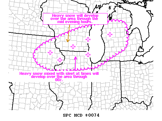
When And Where Is This Discussion Valid For? The first portion of the discussion tells the reader the location, time, duration and other similar information of the discussion:
In this case the product is a mesoscale discussion - which is a type of weather discussion that focuses on shorter term events, usually less than 6 hours in duration and covering an area no more than about 1000km in size (For a detailed explanation you can see the Storm Prediction Center Website Mesoscale Discussion Link) . For this particular discussion it was issued at 339pm CST Friday January 20, 2006 from the National Weather Service Storm Prediction Center in Norman, OK. The areas that it was issued for are northern and eastern Iowa, southern and eastern Wisconsin, northern Illinois, the far northwestern portion of Indiana and southwestern, central and northern lower Michigan. The topic of the discussion was the winter precipitation occurring in these areas from a period of 2139Z-0345Z that day, which corresponds to 339pm-945pm CST on January 20, 2006.
The above paragraph is discussing the bands or areas of heavy snow that are causing snowfall at a rate of about 1"/hour to occur. They are forecasting that these bands of snow will move east-northeastward from northern and central Iowa into southern Wisconsin and then eventually into west central and northern lower Michigan by 3Z which is 9pm CST. In my area of the state of Wisconsin, we actually began to receive snow around 3pm CST and it had become heavy in intensity by about 4pm, lasting until about 1130pm that evening. They also mention a second area of heavy snowfall will continue to develop over northern Illinois for a time ending about 0Z or 6pm CST. At that point they feel it will then move into southwestern and central lower Michigan during the time period from 1-3Z which is 7pm-9pm CST. The rate at which the snow is expected to fall is in excess of 1" of snow/hour with some areas in the Chicago metro area and parts of southern lower Michigan getting snow at a rate close to 2 inches/hour. They also state that a mix of sleet will be possible as well early in the period they are discussing (around 6-7pm CST) for an area in northern IL, northwestern Indiana and into southern lower Michigan. What Types Of Data Are We Looking At To Support Our Conclusions?
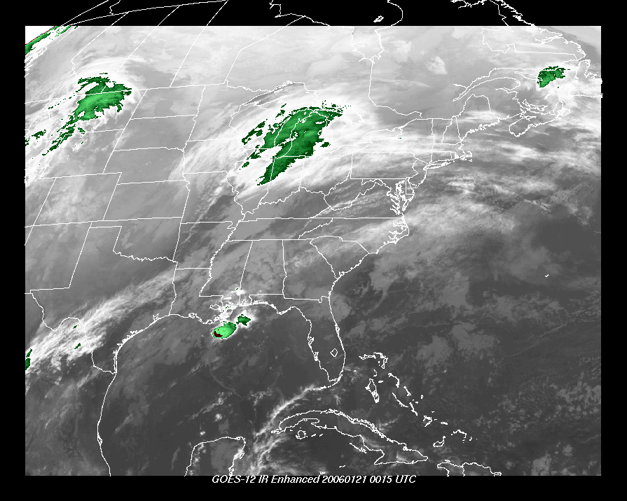
The next paragraph discusses the weather data that the forecasters looked at to make these assumptions. They refer to infrared satellite images showing an area of drier air (known as a dry slot) moving to the east-northeast across northern Missouri and far southern Iowa. Below is a satellite picture that they were referring to and you can see the area as the darker gray shading over those states.
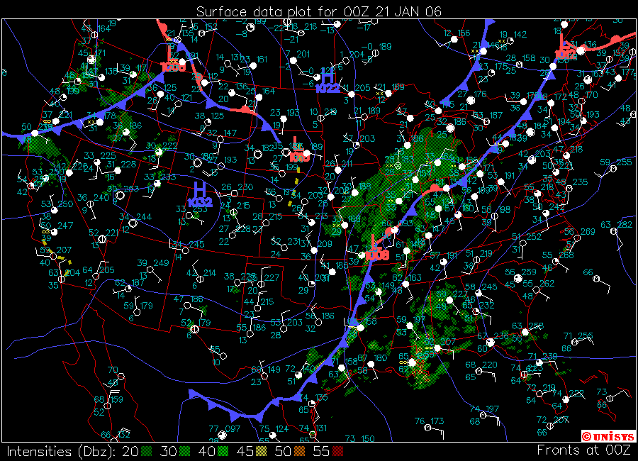
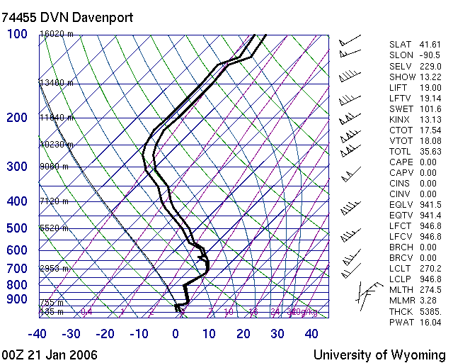
The preceding paragraph is discussing the ability of the atmosphere to force air aloft and as such it will form clouds and possibly precipitation. Often this forcing of air upwards occurs in the presence of a front as is shown on the surface map below. They are also discussing the properties of the atmosphere that will enhance the snowfall in terms of its moisture and/or temperature as you proceed to higher altitudes. I've attached an image of the Davenport Iowa upper air observation (which is immediately below the surface data image) and in looking at it you can see that the two heavy black lines are quite close together for much of the bottom of the image indicating that the temperature and dew point, the point at which the air is fully saturated with moisture, are very close together indicating that the air is quite moist and will likely enhance any precipitation that is occurring. They feel that the snow will continue to move east-northeastward and into southern and eastern Wisconsin through 0Z(6pm CST) and then eventually into west-central and southern lower Michigan between 0Z-3Z (6pm-9pm).
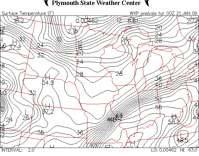
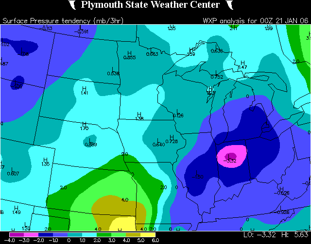
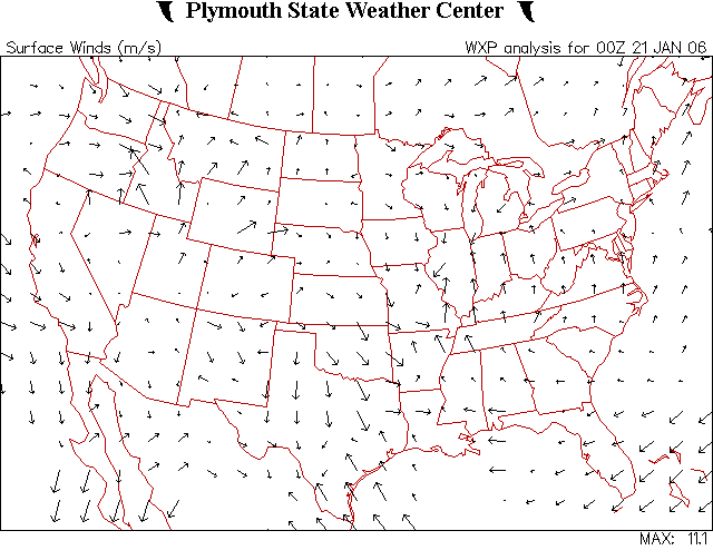
In the previous text the discussion centers on the fact that South of the front mentioned above, large amounts of warm air will be moving into the area, this is called Warm Air Advection and it is abbreviated by WAA in the text. They are discussing the fact that using other means of analysis called a VWP, (which is short for Velocity Azimuth Display Wind Profile which you can read more about by clicking the preceding link) which indicates that in the above sounding you can see that at about the 700mb level the winds are indeed out of the S-SW and this would be consistent with warmer air coming into the area. Also by looking at the images below of 0Z (6pm CST) surface temperatures (first image below) and pressure tendencies (second image below) (areas where the atmospheric pressure is falling or rising the fastest) and surface wind directions as shown in the third graphic image below, you can see that the winds are primarily from a southerly direction over the northeastern Illinois and southern Michigan areas (arrows pointing to the North show the direction the wind is GOING to not where it is coming from)
Further they discuss that based on the satellite image and surface pressure falling to lower levels that there will be more moderate to heavy snow developing in the next 1-3 hours over south-central and southeast Wisconsin and northern Illinois. The forecasters again reference the fact then that the upper levels of the atmosphere around the 800mb level are warm enough for the precipitation to start out as sleet and possibly continue that way until around 3Z (9pm CST). You can look at the above Skew-T diagram to see that the lines indicating temperature are in fact very close to the freezing point which is 0C (32F) on the chart along the bottom. They again mention that parts of northern Illinois and southeastern Wisconsin may see snow falling at a rate of up to 2 inches/hour for several hours from 23Z-2Z (5pm-8pm CST)
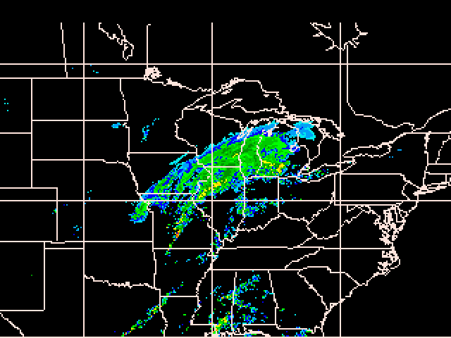
In this last portion of the text, they mention that the largest amount of upward moving air and therefore greatest chance for heavy snow will begin to move into southwestern and central Michigan from 1Z-3Z (7pm-9pm CST) due to the fact that the low pressure center will be moving in that direction. They also mention that the colder air (cold advection) will begin to increase over northern Illinois and southwestern lower Michigan as the low pressure center you can see on the above surface chart moves in that direction and the colder north and northwesterly winds begin to move colder air into the area. Lastly they say that the best estimate for winter precipitation should be along and north of interstate 80 and 90 in northern Illinois and in southwestern lower Michigan it will be north of interstate 94. As you can see from the radar image below from 1Z (7pm CST) the precipitation had in fact moved into those areas as predicted. In my area of Wisconsin the precipitation at that time was consisting of heavy snow that I estimated was falling at about 1" per hour since as of 0Z (6pm CST). At that time I had recorded 4" of new snow since 3pm CST earlier that day.
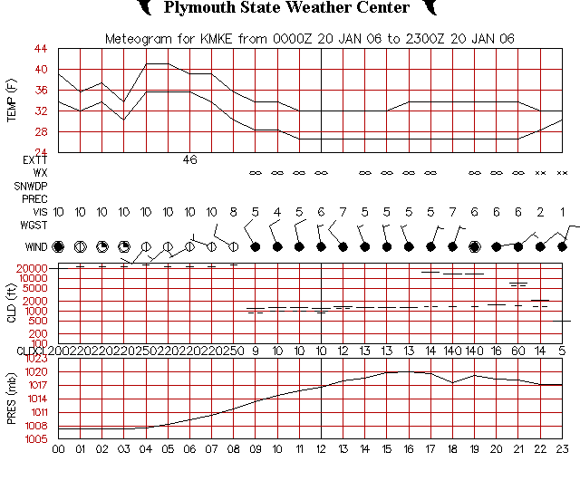
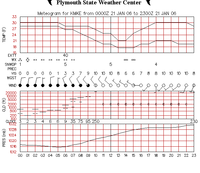
Also below you can see the Meteograms (which are a graphical representation of the weather conditions for a period of time for a given location - in this case Milwaukee WI for January 20 and 21, 2006) for the Milwaukee WI Observation location, and if you look at the time period from about 22Z indicated by the 22 on the bottom of the image from January 20, 2006 (4pm CST) through about 7Z (1am) on January 21, 2006 you can see that in fact Milwaukee was receiving snow during that time as shown by the * symbols on the line indicated by WX (which stands for Current Weather) and further that it was heaviest during the period from 0Z-2Z (6pm-8pm CST) as they predict in the discussion .
My Reflections And Observations As A Result of This Weather Event Overall this particular Mesoscale discussion was quite informative to me as a newer weather forecaster in the manner that it combined many different types of data and information into a fairly compact item. Unfortunately, not all the data that is referenced above is archived for use here. Notably I was not able to obtain the vertical motion forecasts or the vertical wind profile data they reference. The discussion also had extra meaning to me as I was asked by my wife's employer (a local hospital) where she works as an intensive care nurse whether or not they should call in additional staff or keep existing staff longer for concern that replacement nurses may not be able to easily get to the facility. This request for a very immediate forecast for a critical function (providing medical care to very ill patients) added a whole new dimension of pressure to get a reasonably correct forecast for the area as now there was far more at stake than a letter grade in a classroom. People were actively looking to me to tell them what the weather was going to be in the future (admittedly not very far into the future but none the less it was a forecast in any case) and it gave me a very clear idea of the conditions that professional meteorologists work under almost every day in some part of the country or other. As a result of completing this assignment, I have discovered that I need to learn more about how the various data items tie into each other as one package to cause or enhance a winter storm situation as well as helping to predict its future course. I would also like to become more skilled at retrieving the data I want to include in the portfolio's pages, as I had some amount of difficulty in getting what I wanted from the data archives. I knew what I wanted to show and put up on the pages, but didn't know quite how to get the images retrieved or created to show what I was trying to explain in a textual sense. With more use of the various sources of data and trying different options on them, I'm hopeful that I can retrieve or generate the images I want for future projects much better than I was able to here. In terms of skill as a Mesoscale forecaster, I think that I need to remember to look at the entire picture and not just focus down to a very small area, a since city for example or a single item of the overall weather picture occurring at the time, like snowfall amount. There are other things happening and in other locations that could be still affected by this Mesoscale event that are possibly more important than the small local item or area I'm looking at. |