| |
| George R. Kasica
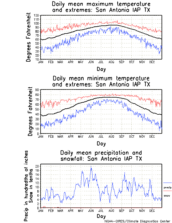
San Antonio Climatology The area around San Antonio, Texas in February (the period for which we were forecasting was from January 29 - February 9, 2007) typically experiences temperatures in the middle 60's for high temperatures and in the low 40's for lows during that time. Precipitation is light with the average day receiving about 0.06" of liquid precipitation. Looking at the extremes for the high and low temperatures in the detailed table you can see however that temperatures have reached to near 90 for a high and as far down as the middle teens for low temperatures, so extreme heat or cold is not unknown to the area.
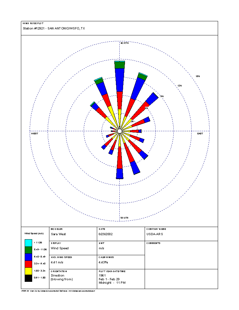
These variations in temperatures in the San Antonio area by as much as 40 to 50 degrees from low to high on a daily basis are a result of the strong heating effects of the sun under the clear daytime sky and the equally rapid cooling under clear, calm conditions at night. These mild days are further caused by the modified maritime air which has its source in the Gulf of Mexico and is brought into the region on south to southeasterly winds. Conversely, San Antonio can experience much colder days and nights due to the influence of more continental air flow brought to the ares on north to west winds behind strong cold fronts. You can see the obvious prevalence of wind directions in the wind rose for February which clearly show the prevailing northerly and southeasterly winds (click for full size image). In February those directions were almost equally split with 12% from the NE and about 8% coming from a milder SE direction . Overall temperatures for San Antonio range in the low 60's for highs during the winter months on an average basis, though they have seen days as warm as 89 back on January 30, 1971. For a detailed look a the daily average and extreme temperatures click here to open a new window to daily normal high and low temperature and extreme readings provided by National Weather Service Forecast Office in San Antonio Texas NowData resource. In terms of precipitation, measurable snow is rare, though not unheard of, in San Antonio and does occur every three to four years with the city receiving amounts as large as 2-4" about once every 10 years. The driest months of the year are from December through March and again in July. And this again reflected in the average daily precipitation totals that you can see in the detail that they area received about 0.06" of precipitation daily during the month of February. (All of the above climatic statistical data was provided courtesy of the San Antonio National Weather Service Forecast Office climatic narrative site). The above items show clearly that the climate of San Antonio, while not as extreme as some other locations in the continental United States, does present some challenges in terms of forecasting, especially in terms of it's temperatures extremes and the occasional possibilities of snow, though forecasting an 18" blizzard followed by -20F temperatures would certainly be stretching the boundaries of extreme, so we need to also keep in mind what is reasonable for the location in terms of it's historical climatology while we make our forecasts. |