| |
| George R. Kasica
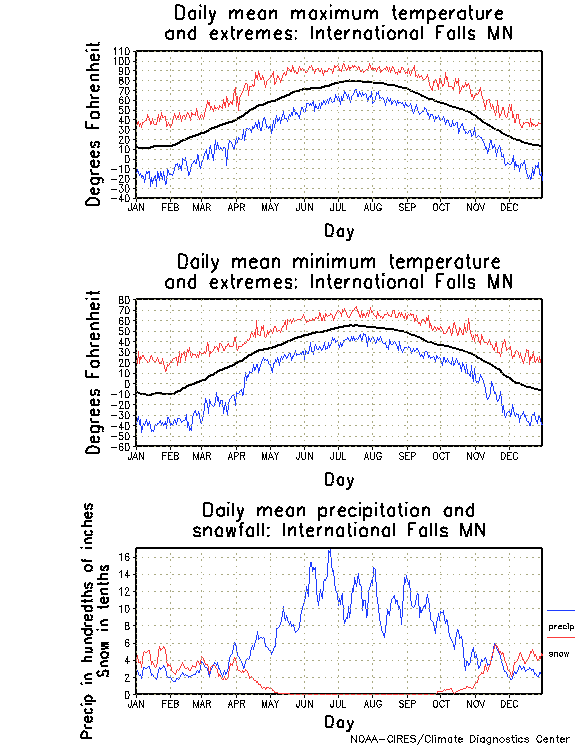
International Falls Climatology The area around International Falls, Minnesota in February (the period for which we were forecasting was from February 12 - February 23, 2007) typically experiences temperatures in the upper teens to upper 20's for high temperatures and in the single digits to -10 degree range for lows during that time. Precipitation is light with the average day receiving about 0.03" of liquid precipitation. Looking at the extremes for the high and low temperatures in the detailed table you can see however that temperatures have reached to as high as 58 for a high and as low as a bone chilling -48 degrees, so a truly wide range of temperatures is not unexpected in this area during the month of February. On occasions, during this period temperatures have been known to fall below zero and fail to rise above zero for a week or more at a stretch.
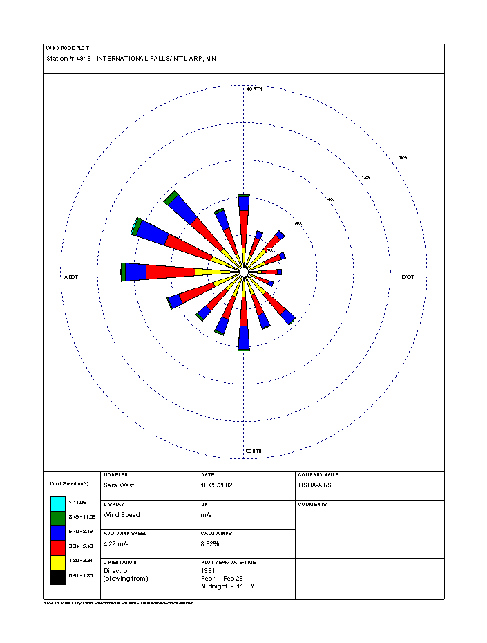
Looking below you can see the obvious prevalence of wind directions in the wind rose for February which clearly shows the prevailing west to northwest winds (click for full size image). In February these winds also averaged speeds near 20 mph on many days. Often times the result of these strong W-NW winds was that the area was covered by a mass of cold arctic air that helped to obtain some of the extremely low temperature readings mentioned above. (The information for the detailed look at the daily average and extreme temperatures was provided by the National Weather Service Forecast Office in Duluth Minnesota NowData resource.) . In terms of precipitation, measurable snow is common here, though the average amount received in each occurrence is not large by some standards, only about 10.'5" for the entire month and they typically receive this on about 3 individual days, therefore the average would be around 3.4" of snow per occurrence. Also the snow received is normally relatively dry and light in terms of water contained in it since the average liquid equivalent for the month is 0.64" giving a ratio of about 16:1 for the snow when melted to water which is somewhat drier than the normal average value of 10:1 (All of the above climatic statistical data was provided courtesy of the Duluth Minnestota National Weather Service Forecast Office climatic narrative - click to view full report). The above data shows that the climate of International Falls, Minnesota is far more extreme in terms of temperatures than the first city in the forecasting competition, San Antonio, Texas, and it does present some significant challenges in terms of forecasting, namely in terms of it's temperature extremes and the frequent possibilities of light to moderate snow. |