| |
| George R. Kasica
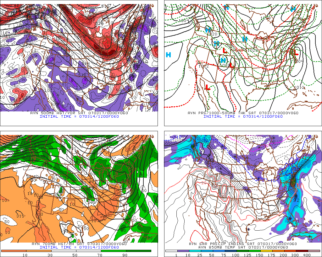
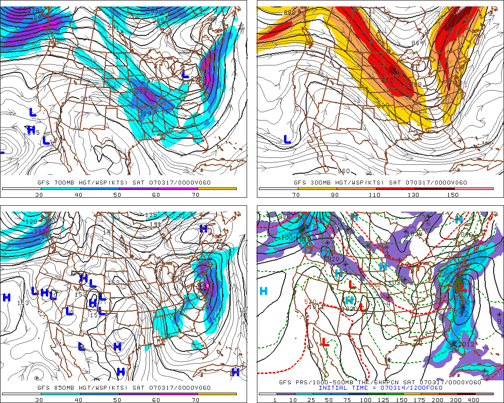
Lessons Learned from Atlantic City, New Jersey March 16, 2007 precipitation forecast error The "big picture" for Atlantic City, New Jersey on March 16-17, 2007 as shown in the 0Z AVN model forecast on the lerft is one of a major rain event. Looking at the lower right panel of the forecast graphic you can see that the area around Atlantic City is predicted to receive near 1.50" of rain during the period. Taking a closer look at that area with the middle image of the 0Z WRF model regional close-up of the area confirms that the models are indeed predicting a major rainfall event for the area during the forecast period with this model also predicting rainfall in the neighborhood of 1-1.25". The reasoning behind the prediction of the large amount of rainfall is the negatively tilted 500mb trough that is expected to be approaching the east coast, with an area of vorticity centered directly over a developing surface low just east the Atlantic City area. Also in the last image on the right, the upper level wind forecast from the GFS model, you can see the right entrance area of a jet streak very near to the intensifying low pressure center adding yet more lift to the atmosphere and helping to enhance the precipitation amounts.
Taking a closer look at the various KACY MOS Outputs (provided courtesy of the National Weather Service Meteorology Development Lab) yielded a MOS precipitation range as follows for each of the three models at 12 and 18Z:
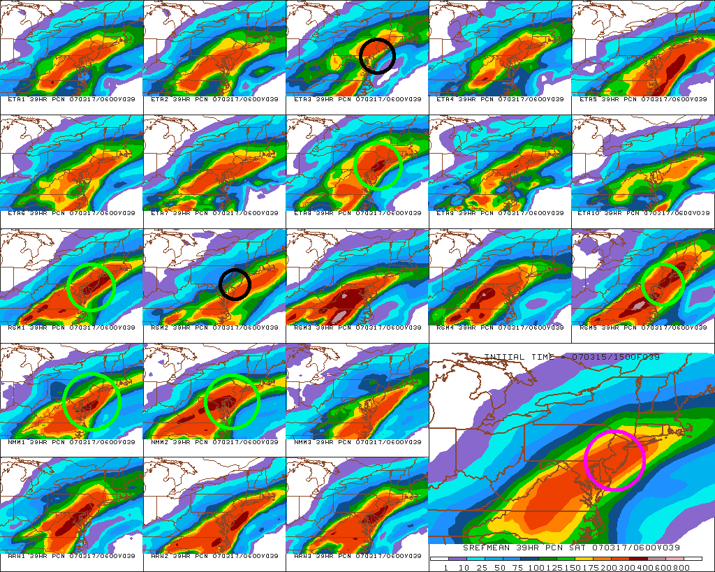
12Z NGM 1.75-3.47" The consensus forecast for this based on these numbers was 2.26" of precipitation. Given the large amount of precipitation expected I decided to also look at the 15Z SREF model output for precipitation from the Pennsylvania State University Department of Meteorology E-Wall to see if it offered any confirmation or contradiction in this regard as its not often that a location receives that amount of rain in a twenty-four hour period. As you can see below it showed a similar amount of precipitation below in that it indicated a total of nearly 3.00" of precipitation by the end of the forecast period at 6Z on March 17, 2007 (purple highlighted circle on the large lower right image). One interesting thing to note on the below image of the 15Z SREF output is that the mean precipitation total over Atlantic City, New Jersey was predicted to be around 3.00, yet several of the individual members of the model showed far different amounts of precipitation some far less (namely items ETA3 and RSM2 were about 1.50" of precipitation - black highlighted circles) and several members predicted far more than 3.00" of precipitation (namely ETA8, RSM1, RSM5, NMM1 and NMM2 predicted close to 4.00" of rainfall - bright green highlighted circles). Considering all of these various data items led me to conclude that the area would be the recipient of a major amount of rainfall, and therefore my forecast for the day was for 2.50" of rain. I also forecast a high temperature of 41, low of 25 and winds of 25 knots. Little did I know that I should have paid munch more attention to the lower total members.
The actual results for the day's precipitation totals were dramatically different as you can see in the final day 4 Weather Challenge results with Atlantic City having a high temperature of 41 degrees, a low of 30 degrees, winds of 43 knots and only 1.24" of precipitation - only about half of what I had forecast. So what went wrong with the forecast and what did I learn from this error? Looking at the GFS model forecast below on the left you can see that if it had come to pass as predicted the winds at 850mb would have been from a southeast direction off of the Atlantic Ocean and as a result would have provided a great deal of moisture for the production of precipitation. Further looking at the right hand AVN model image you can see that the surface winds also would have been from a southeasterly direction as well.
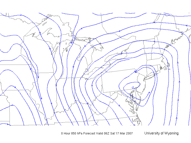
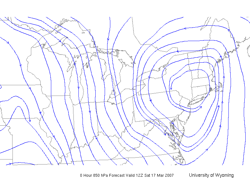
What in fact did occur? Taking a look at the METARs for the area from 6Z on the 16th until 6Z on the 17th you can see that the surface winds in fact stayed more from an E-NE direction as shown by the green highlighted directions up until the cold front passed through around 2Z and the winds became northwesterly. Looking at the images below from the University of Wyoming Department of Meteorology web site you can see that the winds at 850mb in fact stayed south through the entire period and in fact became southwest and eventually west-northwesterly after 12Z on Saturday morning.
The result of the winds not being from a southeasterly direction was that the moisture that was expected to be delivered over Atlantic City never arrived in the quantities that were forecast and as a result the precipitation received was correspondingly far lower than what I had forecast. So what did I learn as a result of the missed precipitation forecast error? Once again, I made the a similar error to what I did in Tucson, Arizona in that I need to clearly look at and consider more sources of data at more levels than just the surface observations and forecasts than what I had in making this forecast. Again in this case a good example of this is that the 850mb wind forecasts that were available from the University of Wyoming would have clearly showed that the abundant moisture that was predicted to arrive by the MOS forecasts and the 15Z SREF were in fact not likely to occur. As a result, had I taken a look at this source of data I could have reduced my expectations for rainfall and, although I may still have over-estimated the amounts, I would probably not have done so by almost double. |