| |
| George R. Kasica
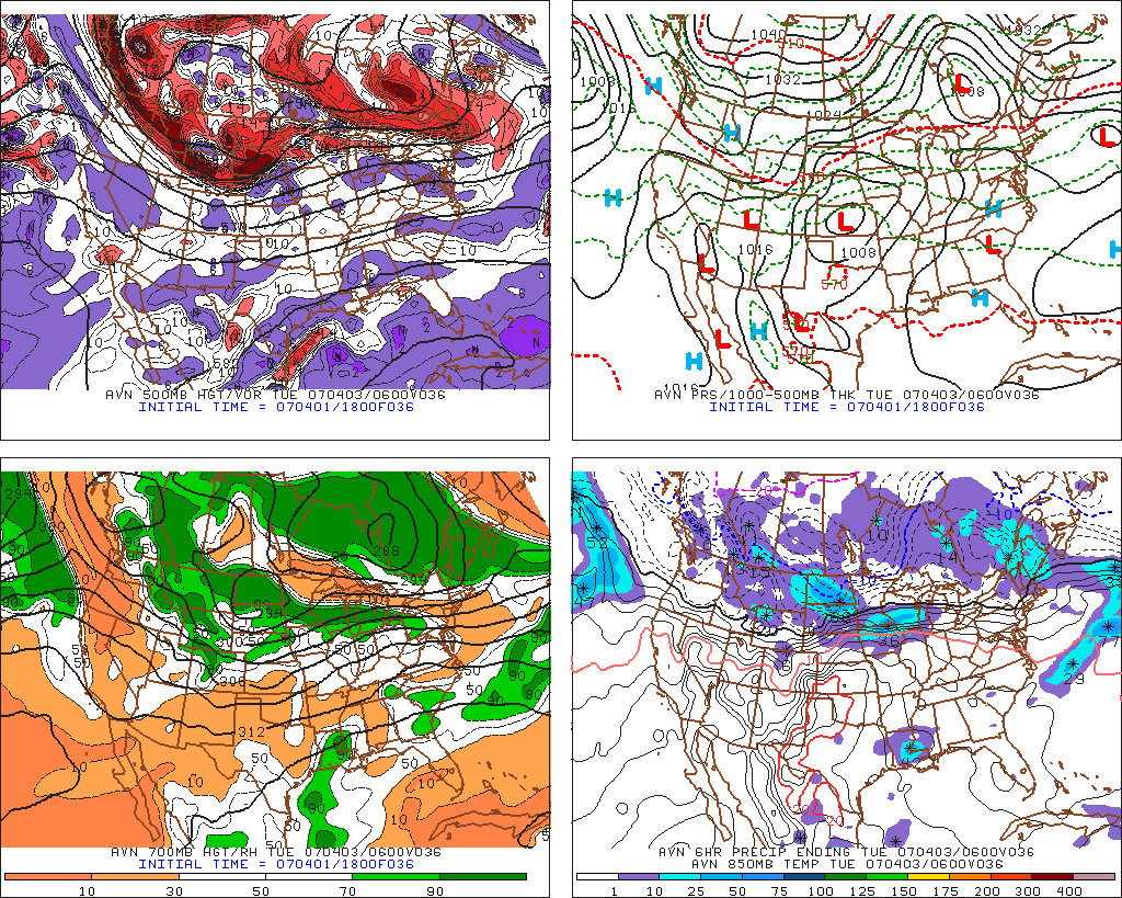
Lessons Learned from Rapid City, South Dakota April 3, 2007 correct forecast The "big picture" for Rapid City, South Dakota on Tuesday April 3, 2007 was one with yet another low pressure center passing to it's south and a negatively tilted 500mb trough just to the west of the area that would likely pass over the city during the forecast period. Given that the low was to be so far to the south of the area however, the chances of significant precipitation were expected to remain slight.
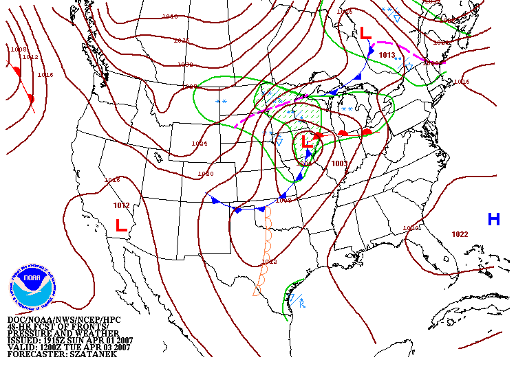
Looking at the April 3, 2007 12Z surface forecast below you can see that the lows position was already expected to be far to the east over Iowa at this time with only a weak trough of low pressure and a slight chance for light snow in the area by that time.
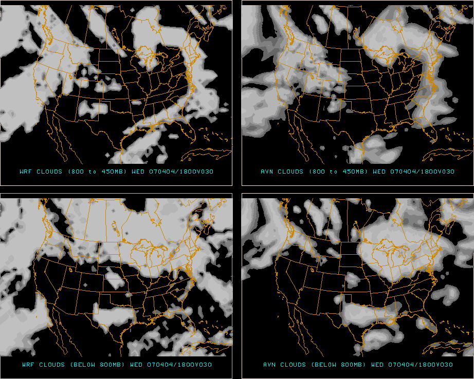
As a result of this rapid progression of the system, I felt that there would be little, if any, precipitation received in the area during the forecast period and also that the skies would be clearing and winds lessening late in the forecast period as the low pulled farther to the east of the city setting the stage for the low temperature to occur late in the forecast period. One other thing to consider given the terrain and climatology of the area was the possibility of downslope winds causing effects on the cloud cover and as a result possibly the temperatures. Over the previous two weeks at Atlantic City, New Jersey and for the first week of forecasting here at Rapid City, South Dakota we had learned quite dramatically that these types of winds can have a huge effect on the temperatures in the area, so I was paying particular attention to them at this time. Looking at the MOS outputs for the city you can see that all three MOS models (provided courtesy of the National Weather Service Meteorology Development Lab) outputs predicted winds to be from the NW-N throughout the forecast period, an almost perfect direction for downsloping winds which would result in eventual clearing skies possibly and also lead to substantial cold air advection into the areas as well as the flow was from an area significantly colder than Rapid City at the time. To further support my idea of clearing skies late in the period I also looked at the 30 hour cloud forecast from the Pennsylvania State University E-Wall that from both the AVN and WRF models as shown below that was valid at 18Z on Wednesday April 4th, 2007. In looking at it below you can see that the clouds are either gone over Rapid City as seen in the upper left and lower right images (WRF 800-450mb forecast and AVN clouds below 800mb respectively) or very nearly gone as seen in the upper right AVN 800-450mb forecast or the lower left WRF clouds below 800mb chart. All of these images support the idea that it would likely be clearing in some form late in the forecast period and with the winds expected to become much lighter as shown in the MOS forecasts earlier, it seemed relatively certain that the low temperature would occur late in the forecast period as well.
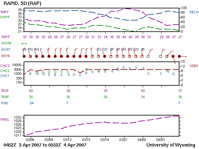
As a result of the indications for a cloudy day with clearing skies late in the period and decreasing winds I felt that the low temperature would occur late in the period. In looking at the MOS outputs the consensus numbers for the various models came out with a high temperature of 38, a low of 24 and winds of 22 kts. All of the models also predicted little or no precipitation during the forecast period, the only exception being the 12Z NGM MOS that predicted between 0 and 0.09" of precipitation from 6-12Z in the early part of the forecast period. As a result the consensus number for precipitation was a very small 0.02". In considering the consistency of all of the data I chose to go with a forecast high temperature of 38, a low of 25 and winds just slightly higher than the MOS value at 25 kts. and 0.00" of precipitation as I didn't feel that the chances of receiving the possible 0.02" were significant. Overall, as you can see I felt that the MOS consensus forecast has a good grasp of the situation in the area and I didn't see any reason to make any major changes to the values that it came up with. I did add one degree to the low temperature just due to the cloud cover being potentially so persistent late into the period, and if it didn't in fact clear out as expected the temperature wouldn't drop early as much as predicted. The actual results for the day were very close on all the forecast items with the actual values being a high temperature of 40, a low of 26, winds of 26 kts. and 0.00" of precipitation as shown by the Weather Challenge Day 5 Final Results. The overall error in the forecast was not large, 2 degrees on the high and 1 degree on the low temperature and 1 knot on the wind speed. There was no precipitation error, because as forecast, they didn't receive any measurable precipitation. All in all this was a very good forecast, and further in looking at the meteogram for Rapid City below you can see that in the top panel the purple line that indicates temperature did in fact reach the low temperature late in the forecast period around 03Z and at the same time the second panel shows the clearing skies (empty red circles) and decreasing NNW downsloping winds (notice the single barb on the wind indication third from the right indicating a wind of about 10 kts) also as predicted earlier.
So what was the lesson learned here by a correct forecast? I think for myself, the biggest lesson learned is that if I take a thorough look at the various pieces of information and take the time to consider the implications of them, I can actually make a very accurate forecast for a city that I've never been making a large number of forecasts for prior to this. Over the course of this semester the one thing that has consistently caused me difficulty in making consistently accurate forecasts has been my lack of looking at all the data that is relevant to a given forecast situation. By that I mean, not just looking at a "standard set" of items each day (for example the MOS output numbers or the graphical model guidance products such as the WRF or the NGM forecast graphic loops off the Pennsylvania State University e-Wall) but to remember to look at items that I may not normally consider important, such as the cloud forecasts from above of or to consider the effects of any local geographical features in the forecast (in this case the NNW downsloping winds) and adjust my forecasts accordingly if it's necessary. The other thing this has taught me is to always be looking for what might be considered subtle items of the forecast, not necessarily big features, but small things (such as the winds getting slightly lighter and changing to the NNW) that while they may not have a major impact on the final forecast, if I remember to consider them carefully in the process may make he difference from getting a fairly close forecast to a very accurate forecast. I feel that if I can remember to consistently apply these "rules" to my forecasting in the future and keep myself open to the continual learning of new tools and methods that I can further improve the accuracy of my forecasts as well.
|