Weather Roundup - Weekly Recap
Caribou, Maine KCAR
10/31/06 - 11/04/06
Introduction
Caribou proved to be a very difficult city to forecast for due to the nuances of cloud cover versus frontal passage. Precipitation was forecast by the progs and NWS nearly every day, yet only occurred on one day. Temperatures hinged on the timing of the cloud cover, which at one point moved in much more quickly than anticipated. And the winds throughout the forecast period were determined to be higher than MOS or the other tools predicted.
Below is a table showing actual high and low temperatures and climate norm high and low temperatures, maximum sustained winds, actual precipitation and climate norm precipitation for the four forecast periods of the week.
| Timeframe | Actual High |
Norm High |
Actual Low |
Norm Low |
Max Sustd Wds |
Actual Precip |
Norm Precip |
| 06Z 10/31-06Z 11/1 | 41 | 45 | 31 | 30 | 16 | 0.02 | 0.10 |
| 06Z 11/1-06Z 11/2 | 49 | 44 | 30 | 30 | 17 | 0.03 | 0.10 |
| 06Z 11/2-06Z 11/3 | 43 | 44 | 27 | 29 | 12 | T 0.00 | 0.10 |
| 06Z 11/3-06Z 11/4 | 39 | 43 | 22 | 29 | 17 | 0.00 | 0.10 |
06Z Tuesday 10/31 - 06Z Wednesday 11/1
On Tuesday, Caribou was finally out from under the influence of the low pressure system that had passed to its northeast. A high pressure ridge was in place with a westerly flow. Winds were moderate, with maximum sustained coming in at 16 knots, which kept the low and high temperatures warmer/cooler than climatology. In addition to the winds, cloud cover from the approaching warm front moved in around 18Z, which was quicker than anticipated on MOS and progs, helping to keep the low and high temperatures higher/lower than climatology. Precipitation was measured at 0.02 by 06Z 11/1, garnered from light rain from time to time overnight. The winds, temperatures, cloud cover and precip can be seen on the meteogram
The precipitation was the result of the approaching warm front, shown in the above surface analysis as just south-southwest of Caribou. The wind shift from the front can also be seen on the meteogram, with the tightening pressure gradient accounting for the stronger winds.
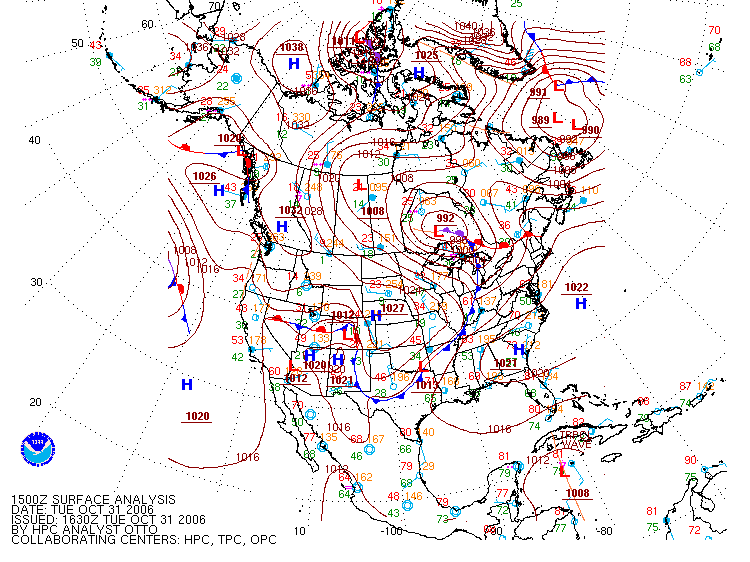 |
| This surface analysis shows the low pressure system to the northeast of Caribou and the high pressure ridge extending from offshore across Caribou into eastern Canada. Note the warm front approaching from the south. Image from the Hydrometeorological Prediction Center (HPC). |
06Z Wednesday 11/1 - 06Z Thursday 11/2
The frontal boundary for the warm front passed to the northeast of Caribou, and the cold frontal boundary passed to the east of Caribou, leaving cloudy conditions until 12Z. Clearing at 12Z allowed for solar heating to bring the high temperature up 5 degrees over yesterday's high at 48ºF. However, the cold air advection kicked in Wednesday afternoon, and the low temperature of 31ºF for the 06Z-06Z period actually occurred at 06Z 11/2. Winds were still higher than MOS at 17 knots due to the low pressure gradient. The temperature spread, winds and cloud cover can be seen on the meteogram.
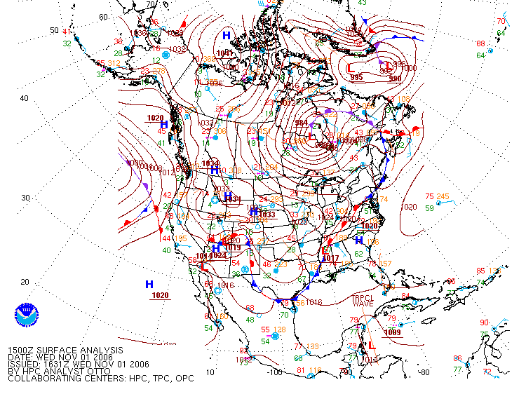 |
| This surface analysis shows the location of the low pressure system and its warm and cold frontal boundaries. Caribou is just west of the cold front and southwest of the warm front and occluded front triangle. Image from the Hydrometeorological Prediction Center (HPC) |
06Z Thursday 11/2 - 06Z Friday 11/3
On Thursday, the warm/cold frontal boundary remained just offshore, which kept its influence on Caribou by bringing a continued chance of showers and higher sustained winds of 12 knots, though these winds are lower than the previous two days. However, the meteogram shows no precipitation, with a trace recorded on the Climate Report for the forecast period. The high of 43ºF was once again closer to climatology, as was the low of 27ºF.
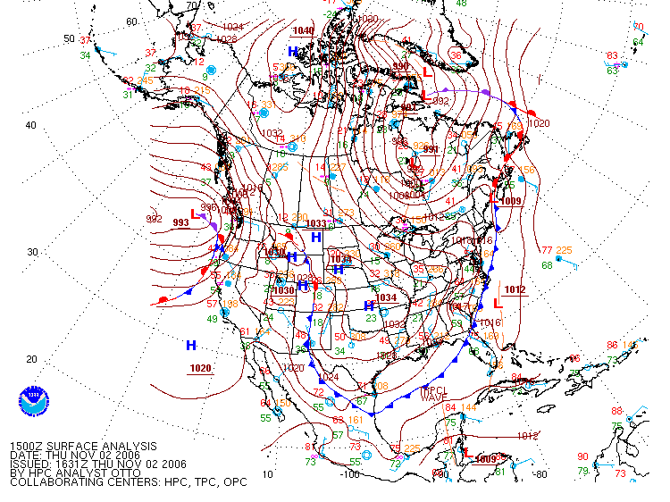 |
| This surface analysis shows the warm/cold frontal boundary sitting offshore along the entire eastern coast. Note the low pressure gradient now poised to affect the Caribout area. Image from the Hydrometeorological Prediction Center (HPC) |
06Z Friday 11/3 - 06Z Saturday 11/4
By Friday, the low pressure system and its accompanying fronts had passed out of Caribou, leaving behind a high pressure ridge building over the area. Westerly flow dominated the picture, with cold air advection allowing the high to reach 37ºF at 16Z before clear skies clouded up again. Cold air advection is also responsible for moving the low temperature of 22ºF from its usual time to 11Z as it moved into Caribou, which was 7 degrees below climatology. You can see this progression of temperature lowering on the meteogram. With the high pressure gradient in place, winds were again higher than MOS at 17 knots.
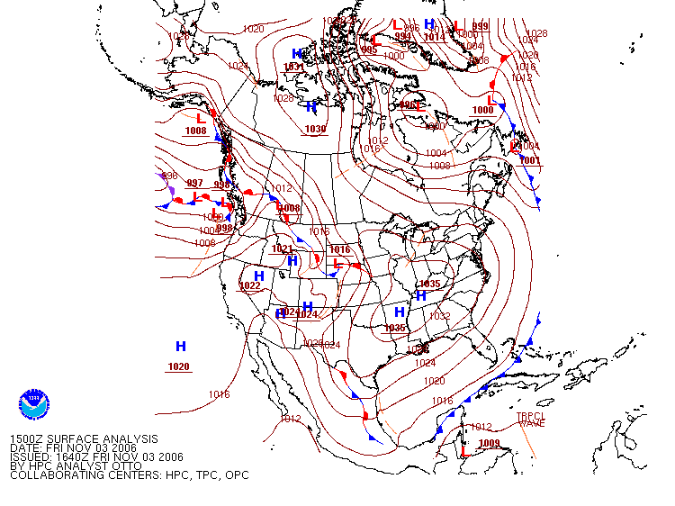 |
| This surface analysis shows the low pressure system and its accompanying frontal boundaries moved considerably northeast of Caribou, and a high pressure ridge building over the area. Image from the Hydrometeorological Prediction Center (HPC) |
Summary
Caribou is very much influenced by the timing of cloud cover and frontal boundary passage. These subtle changes can affect the temperatures by several degrees. Winds have historically been higher than forecast tools anticipate, owing to conditions such as cloud cover that are not accounted for. And precipitation was surprisingly lower than anticipated due to the drier air that was not accounted for by QPF charts, which forecast precipitation chances.