Challenges
Part of this assignment is to list the main issues faced by the
forecasting group during the week, as discerned from the discussion threads.
Below are the issues faced each day of the forecasting period, along with
thoughts and observations from the group. I've followed that up with the
actual occurrences and some comments about my own forecast in relation to the
threads.
A
table with the three MOS model forecasts in comparison to the norms and
actuals points out where MOS busted on temperatures and winds. I also included my
forecast for each day on this table. From this table you can see the
challenges that presented themselves during this week - the winds vs. MOS
predictions, the precipitation amounts for Days 1 and 2, and the high and low
temperatures for Days 1 and 2.
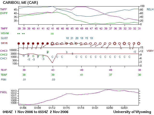
06Z 10/31 - 06Z 11/1
For the first day of our forecast
week, discussion began with the timing of the front's arrival being the main
forecast challenge. This would affect high and low temperatures due to
when cloud cover could be expected to move in, as well as precipitation chances.
All agreed that the system was weak and not impressive, and seemed
moisture-starved. Discussion hinged around whether to forecast very little
precipitation, or none, and whether any of the precipitation that did fall would
occur before the end of this forecast period. It was thought at first that
the low temperature would occur early in the forecast period before cloud cover
moved in. However, this was also when the winds were forecast to be the
highest, dying down during the progression of the day, and winds would keep the
low temperature up. On the other end of this spectrum, it was thought that
perhaps clouds would clear out by the end of the forecast period, and with the
lighter winds this would allow evaporational cooling to drop the low temperature
considerably. The group finally determined that a low temperature lower than MOS would be appropriate. For the high temperature, the group felt that higher
than MOS would be more accurate due to the WAA ahead of the front. Which
brought back the challenge of the timing of the front - would it pass early in
the period or toward the end.
As it turned out, there were
persistent clouds early in the forecast period that moved in earlier than
expected, with winds up to 16 knots, which kept the low for Monday night a bit
higher than MOS. However, the clouds cleared by 12Z allowing the
temperature to drop to 32°F before beginning to climb with solar heating.
Clouds moved back in at 18Z and a period of calm winds occurred at 20Z-21Z,
allowing the high temperature to reach only 41°F before the winds shifted to the
south with the passage of the warm front. On the meteogram below you can
see this cloud cover and wind shift, as well as the light precipitation that
occurred between 23Z 10/31 and the end of the forecast period 06Z 11/1.
Precipitation totaled .02, corresponding with much of the discussion about what
amount to forecast assuming precipitation fell at all. I'm happy to say my
forecast was for .02 inches! (see
Table of MOS-Actuals)
 |
| This
meteogram for 06z-06z 10/31-11/1 shows the clouds clearing by 12Z 10/31 and
a low of 32°F, then clouds moved back in by 18Z-19Z 10/31, winds calmed and a
high of 41°F was reached, then the wind shifted to the south-southeast and
precipitation occurred by 23Z 10/31. Image from the
University of Wyoming site. |
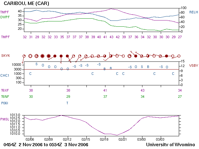
06Z 11/1 - 06Z 11/2
On the second day of our forecast
week, the amount and timing of precipitation started out being our biggest
challenge, but was soon overshadowed by the bigger problem of cloud cover. All
agreed the precipitation would occur early in the period, and the minimum
temperature would occur toward the end after skies had cleared and cold air
advection behind the front had moved in. There was much discussion
regarding clouds clearing briefly then reappearing after the passage of the
front. It was thought that they would, which set the stage for a high
temperature forecast lower than MOS. Winds weren't discussed in this
thread, which would have been of benefit since I predicted them to have died
down closer to 7 knots for this day.
The cold front followed the warm
front and came through with westerly winds and clearing at 12Z. The timing
of this frontal passage was well progged for between 12Z-15Z. Winds went
up to 17 knots and were quite gusty from 15Z-19Z, and skies remained clear for
the rest of the period, allowing the high to climb to 49°F with solar heating
and weak cold air advection. This is one of those classic examples of
solar heating outweighing cold air advection behind a frontal boundary.
The group's consensus that precipitation would occur early in the period was
correct and, though moisture-starved, the total amount came in at .03 inches.
I'd forecast .02 again. (see
Table of MOS-Actuals)
 |
| This
meteogram for 06z-06z
11/1-11/2 shows the south winds and cloudy conditions through 11Z, with
rain at 06Z-07Z 11/1, then clearing skies by 12Z with a wind shift to
the west, winds pick up, and temperatures begin to climb by 13Z 11/1.
Image from the
University of Wyoming site. |
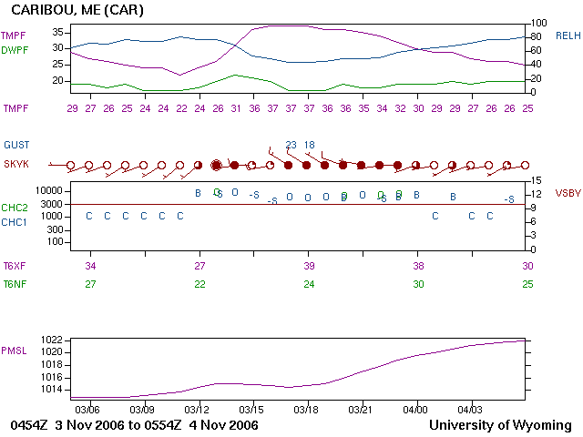
06Z 11/2 - 06Z 11/3
On our third forecasting day,
precipitation again started out as our main challenge. The model guidance
was contradictory and the group waited for the 15Z
SREF ensemble to come out to get a better feel for it. This
precipitation was related to a low that was forecast to develop over the
Atlantic states and move quickly up the Eastern Seaboard. The location,
timing and track of this low was the main question, and as the day progressed,
it appeared the low would track east of Caribou. It was pointed out that
the 700 mb relative humidity dropped in close proximity to Caribou during the time forecast
for precipitation chances, therefore dry conditions would most likely prevail.
Winds were thought to become light, but once again came out higher than
forecast. High and low temperatures were weighed against CAA being offset
by solar radiation, cloud cover vs. clear skies, light winds and mixing. The
general consensus was that MOS was a bit high on the high temperature (due to cloud
cover and CAA) and on the low temperature (due to clearing skies and light winds).
After all the guidance and SREF
weighed in, the actual amount of precipitation came in at a trace at 12Z.
The low temperature reached 29°F before clouds moved in briefly from 08Z-12Z,
when skies cleared again. The high reached 43°F at 19Z with partly cloudy
skies, and the clouds remained intermittent through 04Z. The clear skies
from 05Z-06Z 11/3 allowed the temperature to drop to 27°F at the end of the
forecast period. Unfortunately, I'd forecast the precipitation from the
12Z SREF ensemble, since the models were so disparate, and it was way too much.
If I'd waited until the 15Z run, when precipitation came in at 0.01-0.10, I
might've gone lower due to the fact that the low was more east of Caribou and so
were it's precipitation chances. (see
Table of MOS-Actuals)
 |
| This
meteogram for 06z-06z
11/2-11/3 shows clouds moving in by 07Z-08Z where the low dipped to
29°F, winds picking back up from the southwest-south at 09Z, skies
clearing again by 13Z with winds more westerly, the high climbs to 43°F
at 19Z, and there is intermittent cloud cover at 23Z 11/2, 02Z 11/3, and
04Z 11/3. Image from the
University of Wyoming site. |
06Z 11/3 - 06Z 11/4
On the fourth forecasting day, we
had fewer challenges than the beginning of the week. At least there was no
precipitation to worry about this time. MOS temperature predictions were
fairly close to actuals, and the front had passed leaving the ridge of high
pressure in place. The group believed that MOS had a handle on high and
low temperatures this time, but might still be underestimating cloud cover.
MOS also was higher on its wind prediction, though still a bit low, when it had
been notoriously low on maximum wind speeds throughout the period. A wind pattern emerged for
Caribou that was brought out in the discussion thread: each time the wind
speed dropped, Caribou was under the direct influence of a low pressure system,
and once the low passed the winds picked back up again.
ETA-MOS verified for the high
temperature of 39°F, and NGM-MOS was only one degree off (21°F) of the low
temperature of 22°F. The winds came in at 17 knots, which was still 5
knots higher than GFS- and ETA-MOS. Skies were clear at the beginning of
the forecast period, then began to cloud up briefly at 12Z, cleared somewhat at
15Z, and became cloudy with a shift to northwest winds at 17Z through 23Z.
The low temperature occurred at 11Z under the clear skies just prior to clouding
up briefly, and the high temperature occurred during the cloudy and windy
conditions between 16Z-18Z. I went with a MOS mid-range for the low
temperature, and forecast 22°F, so that worked out well! Also, I went
above MOS on the winds with 15 knots, which was only 2 knots below actuals.
(see
Table of MOS-Actuals )
 |
| This
meteogram for 06z-06z 11/3-11/4 shows the clear skies and light
southwest winds up to 11Z where the low dips to 22°F, then some high
clouds move in briefly, skies mostly clear at 15Z-16Z, but clouds move
back in and winds become northwesterly by 16Z, with the high temperature
of 37°F reached at 18Z 11/3. Image from the
University of Wyoming site. |
Summary
Most of the tools used by all
forecasters in the group were HPC maps, HPC QPF, MOS, eWall progs, eWall SREF
and NCEP SREF, the local AFD, and forecast soundings. A couple of the
class members use Bufkit frequently, and I also used Tabular, Area/Point, and
Zone forecasts from the local NWS site. I wanted to point this out to show
that we were all using the same tools but many times came to different
conclusions regarding what the data were indicating. However, by the end
of each discussion thread, the group had for the most part come into consensus
on the variables of each day's forecast. This was truly a team effort, and
the input from everyone was invaluably beneficial. Many times the threads
held conversations full of bouncing off ideas, which helped to form an opinion
in the first place. Also, questions were asked and errors were caught that
may not have been had we all been on our own.
And what a diverse group - we had
morning people who were kind enough to post the local AFD and get the ball
rolling, and night owls who stayed up to watch the METARS come in to see how the
forecast verified. In between were the posts from different individuals
with different styles, different focuses, and using different tools.
Together, we were able to make a more informed forecast, which I think is
attested to by our standings in the contest.
Back to Main Page
Reflections