| |
| George R. Kasica
METEO 241 Portfolio #1: Remote Sensing as it relates to tropical cyclones The History of Hurricane Jeanne
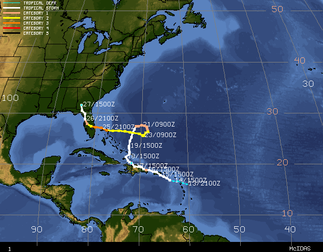
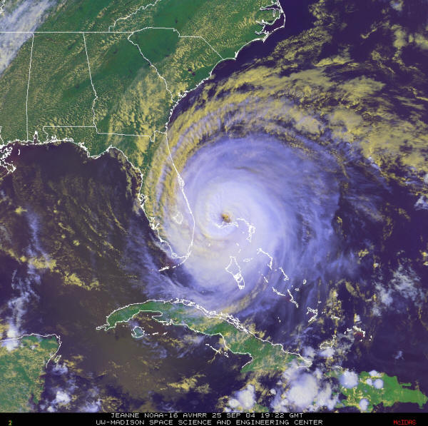
Hurricane Jeanne began as a tropical wave near Africa in the eastern Atlantic Ocean on September 7, 2004 and began to move to the west with little notice paid to it until a tropical depression formed near the Leeward Islands on September 13, 2004. From that point until about September 18, 2004 Jeanne moved to the WNW at around 5-10 knots and gained strength, becoming a tropical storm on September 14, 2004 as it crossed over the Leeward Islands. It then moved over the Virgin Islands and Puerto Rico on September 15th with winds around 60 knots. When it reached the Dominican Republic late on September 16 or early September 17, 2004 Jeanne had intensified to a hurricane with 70 knot winds. This encounter with land however was not kind to the storm and it came out of the meeting a shadow of its former self, a tropical depression with that eventually weakened and then reformed and drifted aimlessly in the Caribbean area for 5 days dumping massive amounts of rain on places like Hispaniola and the Bahamas. Sitting in the calm atmosphere and the warm waters of the Caribbean did much to restore Jeanne however, because by September 23 she was one again a Hurricane with 85 knot winds and heading in a WNW direction straight for the eastern coast of Florida at about 12 knots. Jeanne continued to strengthen over the warm waters and by the time she made landfall at Port St. Lucie on September 26, 2004 at about 8pm EDT (0000Z) she was a 105 knot Category-2 hurricane on the Safir-Simpson Scale. Please be aware that the above is a VERY brief history of the storm based on the full and detailed history of Hurricane Jeanne which can be found at the National Hurricane Center Tropical Cyclone Report on Hurricane Jeanne. Now that you have some background on the history of Hurricane Jeanne lets move on to the first of the data items I will be talking about - the Vortex Data Message. Click the Next Page button below to proceed to take a look inside Hurricane Jeanne at about the time she made landfall or the Previous Page button to go back to the main page.
|