George R. Kasica
METEO 241 Portfolio #4: My Week as
Weather Briefer - Day 2 - September 19, 2006
On the second
day (click to open) of my week as briefer I decided to switch my
focus to hurricane Gordon as at the time hurricane Helene was no threat
to land and hurricane Gordon was on course to strike the Azores in the
very near future. I felt that this might give us all some practice at
trying to accurately predict the track, intensity and time and location
of landfall for the storm.
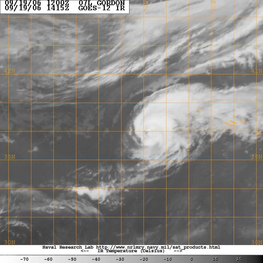
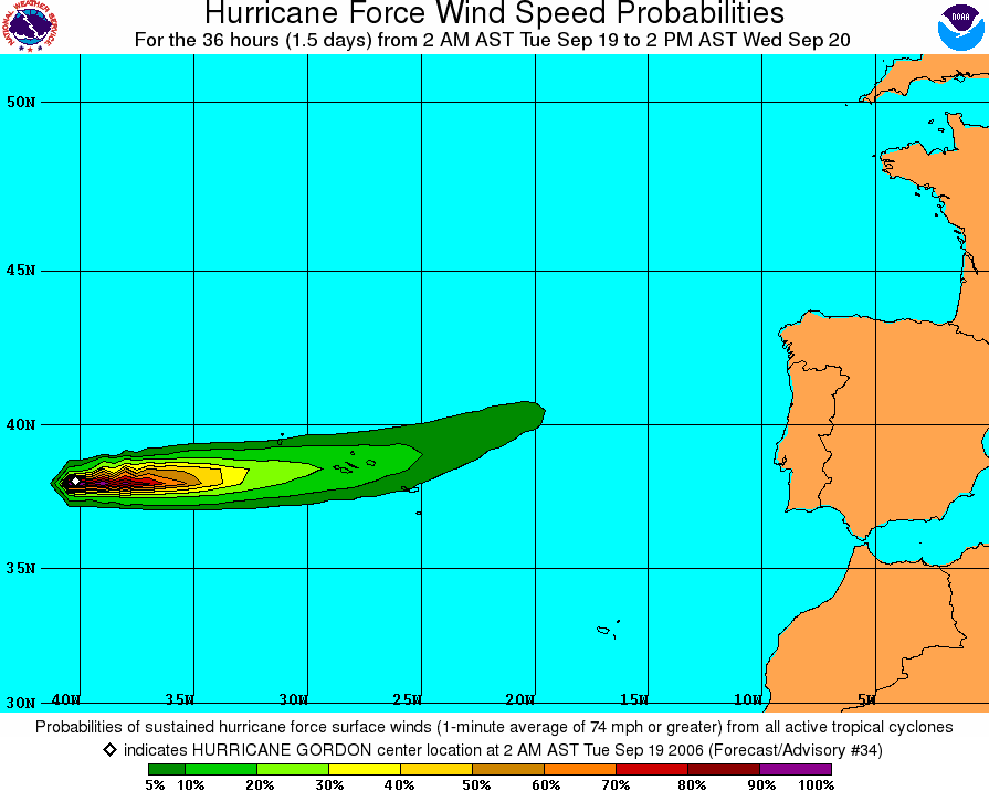
In my initial briefing I used the
IR
image from the Joint Typhoon Warning Center and the
wind probability chart
from the National Hurricane Center. The one question I raised in
addition to the prediction of the track and intensity was why the wind
probabilities seemed to be so low on the above chart.
This question generated a significant amount of discussion
as t why they seemed to be so low, and ultimately an answer was provided by
Robert Sandberg and confirmed as correct by Steve Seman below:
re:
Tropical Weather Briefing #2, Week of September 18
ROBERT SANDBERG - 9/19/2006 10:58 PM |
|
Hey guys,
I think I might be missing something on the original questions here.
The NHC graphics indicate the probability of sustained hurricane force
or tropical storm force winds are based on 1 minute surface wind speed
averages depending on track and intensity. The tropical storm
force conditions have a larger radii than the hurricane force winds as
you can seen on the cumulative distribution.
This brings me to a question. Are the hurricane probabilities lower
due to the intensity and track or is it due to poor model
initialization or combination of both?
CumulativeWindDistribution.gif
|
re:
Tropical Weather Briefing #2, Week of September 18
Steve Seman - 9/20/2006 12:11 AM |
|
| Robert is right. Gordon is a storm
that's barely a category 1 storm (and weakening) as it's moving
through the Azores area, and the area of hurricane-force winds extends
up to 40 miles from the center. But, in reality, the areas
experiencing hurricane-force sustained winds are pretty small within
that larger framework. That lends itself to lower probabilities.
The probability of tropical storm-force winds is much higher, because
they extend out much farther from the center and while it's not
entirely certain that Gordon will remain a hurricane for long, it
surely will maintain the strength of a tropical storm.
TS_Wind_Prob_Gordon.gif
|
Lesson two to remember: Always understand WHAT you
are looking at in terms of a chart and especially the SCALE it is
referencing.
From there the discussion turned to the fact that
Gordon did not technically make landfall as Prof. Grenci observed and was
confirmed by William Burns a short time later.
re:
Tropical Weather Briefing #2, Week of September 18
LEE GRENCI - 9/20/2006 07:22 AM |
|
| Here's the updated cumulative winds.
Looks like Gordo did not, technically, make landfall. Close but
no cigar. Am I correct?
090450P_sm.gif
|
re:
Tropical Weather Briefing #2, Week of September 18
WILLIAM BURNS - 9/20/2006 09:29 AM |
|
Lee, you are right. It just missed. The eye
passed between the islands of Sao Miguel and Santa Maria.
From the Associated Press (2 hrs 36 mins ago)
"The eye of Gordon moved between the islands of Sao Miguel and
Santa Maria, and was rapidly moving east, according to the National
Hurricane Center in Miami."
“As it stands right now it will not make land fall,” said Dave
Roberts, a hurricane forecaster for the National Hurricane Center.
“There are still some winds there. They definitely felt some effect,
but the eye didn’t pass on land.”
The full link: http://www.msnbc.msn.com/id/14907792/
|
To end the discussion thread (and more or less the lifetime of Gordon as
well) Daniel Depodwin brought up the information that the storm was forecast
to become an extratropical system in a short time.
re:
Tropical Weather Briefing #2, Week of September 18
DANIEL DEPODWIN - 9/20/2006 11:07 AM |
|
The NHC discussion mentions that Gordon is
in the process of becoming extraptropical and merging with a cold
front:
A STRONG COLD FRONT IS ALREADY VERY NEAR THE CORE
OF THE TROPICAL CYCLONE AND GORDON SHOULD BECOME FULLY
EXTRATROPICAL LATER TODAY.
The 0z CMC (12 hr--see attached) run has a tough time finding a center
of circulation for Gordon. The Vorticity image (upper right)
clearly shows the cold front just to the East of the Azores but no
sign of the circulation of Gordon. This shows that the core is
basically imbedded in the front at this point.
CMC0z.gif
|
Two lessons were learned from today's briefing by me:
-
Always understand WHAT you are looking at in
terms of a chart and especially the SCALE it is referencing.
-
The models that predict the track of the storm
are not perfect and can have a range of error to them as we saw with
Gordon narrowly missing making landfall in the Azores.
Now that we've looked at day number two, lets move on to day number
three, Wednesday September 20, 2006(click
to continue), or click the following link to go back to
Monday September 18,
2006. |
