George R. Kasica
METEO 241 Portfolio #4: My Week as
Weather Briefer - Day 3 - September 20, 2006
On the third day
(click to open) of my week as briefer I once again switched my focus
back to hurricane Helene as Gordon from briefing day number two had been
downgraded to a tropical storm and Helene continued to be a hurricane
force system with winds of 90 kts. Since the storm was also being
affected by wind shear from the US East coast I had hoped to steer the
discussion in that direction, as we'll see it did go that way, but
several unexpected and very good items were brought into the discussion
by others as well.
The first unexpected item to hit the discussion thread was
the post by Philip Lutzak immediately after the briefing post which got us
our first look at real, live actual vortex data message data from a current
storm system as shown below:
re: Tropical Weather Briefing #3, Week of September 18
PHILIP LUTZAK - Edited 9/20/2006 04:12 PM |
|
We’ve finally got a vortex message; I
found it at the CIMMS page on Helene:
http://cimss.ssec.wisc.edu/tropic/real-time/atlantic/storm/storm3.html
Here’s the text:
WXTLIST WMO=URNT12 MATCH=HELENE
URNT12 KWBC 201739
2006263 1749
VORTEX DATA MESSAGE
A. 20/1717Z
B. 25 DEG 50 MIN N
56 DEG 42 MIN W
C. 500 MB 5567M
D. NA
E. NA
F. 306 DEG 58 KT
G. 229 DEG 28 NM
H. 960 MB
I. 2 C/5136 M
J. 6 C/5185 M
K. NA/NA
L. POORLY DEFINED
M. NA
N. 12345/5
O. 1/1 NM
P. NOAA2 WXWXA HELENE04 OB 12 AL082006
MAX FL WIND 58 KT SW QUAD 1705Z
POOR EYEWALL RADAR PRESENTATION
WXTLIST: done
From the looks of this, Helene isn’t in good shape right now.
Although the pressure is a quite respectable 960mb, the max flight
level (in this case, 500mb) winds found were only 58 knots in the SW
quadrant. Also we can see in “L” that the eye is poorly defined. I
haven’t been able to find the flight plan anywhere yet, so I’m
guessing that they’re still flying around in there and we’ll be
getting more data; it seems unlikely that the highest winds are only
58 knots. But we can see why there has been weakening. Look at the
water vapor image from 1715 in attach 01. There’s dry air getting
pulled into the circulation on the south and west sides, and you can
see the strong south-southwesterly flow associated with the
approaching trough and cold front starting to engage with the storm,
which will soon add a lot of shear. Also, attach 02 shows how her
Dvorak t-numbers have dropped considerably. They were around 6.4 late
last night.
01_2006-09-20_1715_sat_wv_Helene.JPG
02_2006-09-20_1915_Dvorak_ADT.JPG
|
Philip continued in the above posting to break down and decode the vortex
data message and draw the conclusion that the storm was weakening rapidly
due to the dry air the system was encountering as well as the shear that I
had mentioned in my briefing.
Those views were shared by Barbara DeClerck in the following post, who
also introduced us (ore at least myself) to a new term - "saddle point":
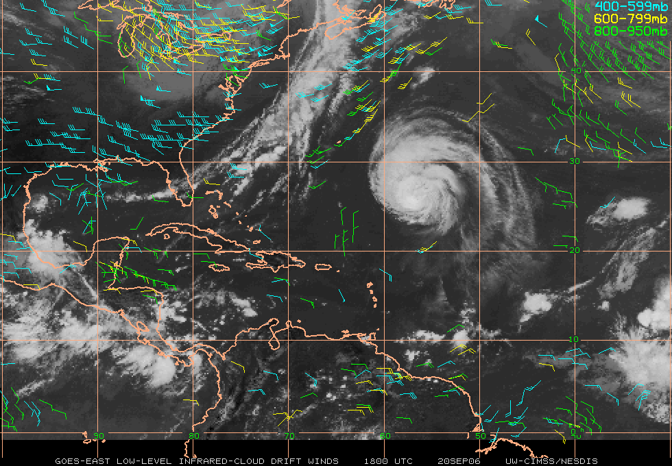
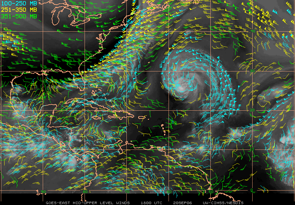
"Based on the QuikScat data at 18Z on 20
Sep, both the upper level winds (Helene_mid_level_winds.gif) and lower
level winds (Helene_low_level_winds.gif) indicate that the storm is
moving into a saddle point (light and variable winds) in both layers.
I think this indicates that the storm will lose its punch, slowing and
getting caught up in the front approaching from the west."
Which as she explained to Philip Lutzak's questioning post following it
was defined as:
"A saddle point is the intersection of two ridges and two troughs.
So, a constant pressure surface looks like a saddle (high in front and
back, low on each side). It's a very descriptive term, wouldn't
you agree? Saddle points tend to be more easily identified on
streamline charts and are typically characterized by light and
variable winds."
An excellent posting and very descriptive definition that added a new
term to my meteorology vocabulary.
Shortly after this another angle was taken on the briefing, that of
cooler upwelling water caused by sea turbulence generated by the previous
storm system Gordon as mentioned and shown by David Williams:
re:
Tropical Weather Briefing #3, Week of September 18
DAVID WILLIAMS - 9/20/2006 06:12 PM |
|
Hi, everyone.
One factor that will hasten Helene's demise over the next several days
is sea surface temperature. Currently, the storm is at a
latitude of 26.6N, and the corresponding SST is 28.10C. However,
cold waters loom just to the north, as the critical 26C isotherm is at
approximately 35N.
Helene will move into the colder waters over the next 2-3 days, as the
corresponding SST is forecast to be 23.65C by 60 hours...
...also, note how close Helene is forecast to move to colder waters in
the wake of Gordon (upwelling?) during the next 24-36 hours...
recent_na_sst.jpg
|
This led me to another good learning point here:
Storms can be and are affected by other systems if they are trailing
them or coming across the same areas of ocean soon after.
In this case the cooler waters stirred up to the surface by Gordon were
adversely affecting the strength of Helene.
Overall, day number three proved to be just as instructive for me as the
previous two. Although the discussion seemed to take on a path and life of
its own at times, many excellent new facts and items were brought up by
fellow classmates such as:
- Always be looking for data - in this case the vortex data
messages that were seen and added by Philip Lutzak.
- Be alert to and ready to investigate new or unfamiliar
terminology such as "saddle point" as shown by Barbara DeCLerck's
posting.
- Remember to look at and consider how other weather events may
affect what you are currently observing as is the case here with the
cool upwelling caused by the previous storm (Gordon) that passed over
this same area a short time earlier as was shown by David Williams.
Now that day three is done, lets continue on to day number four,
Thursday
September 21, 2006(click to continue), or click the following link to go
back to Tuesday
September 19, 2006.. |
