
| |
| George R. Kasica
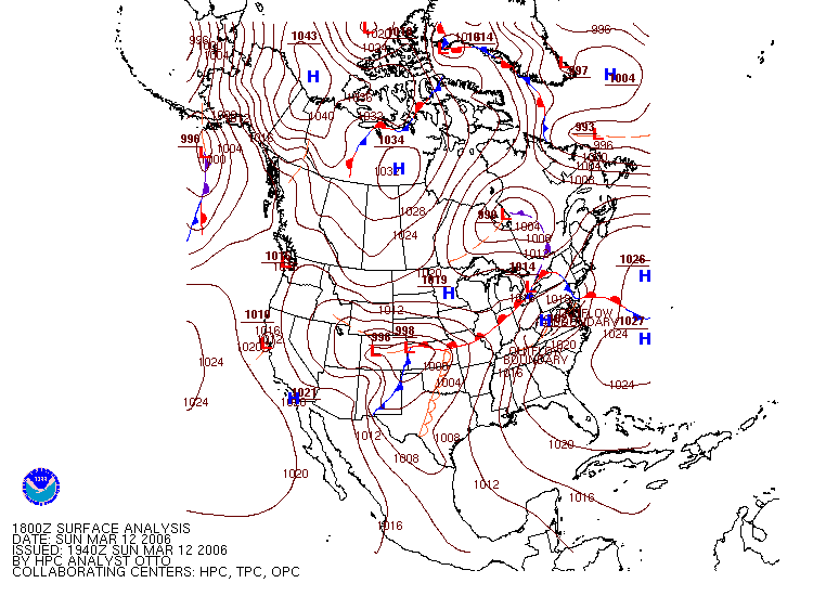
METEO 361 Portfolio #2: Analysis of a synoptically caused thunderstorm In the following discussion I will be presenting various data items to illustrate the outbreak of strong or severe thunderstorms in the area of St. Louis, Missouri on Sunday March 12, 2006 around the time of 17-1800Z which had their roots and developed somewhat farther to the south earlier in the day in an area of extremely warm moist and unstable air. The Big PictureTo begin the discussion I'm first going to talk about the the general synoptic weather picture at the time. To do this I'll begin by discussing the surface weather conditions. As you can see from the image of the surface weather analysis (click on the image for a full scale chart), there was a warm front in the vicinity of the St. Louis, MO area at this time which trailed back to the twin 996mb and 998mb low pressure centers over Colorado.
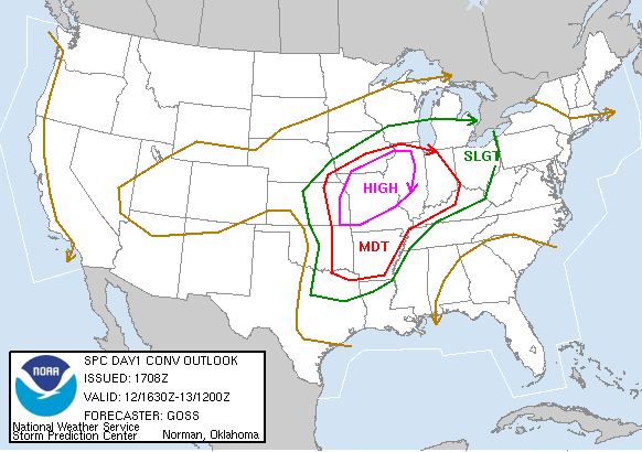
Beginning at about this time the Storm Prediction Center issued a severe weather outlook detailing an area of "high risk" and calling it "an extremely dangerous situation". As you can see from the image below and the discussion text attached to the image (Click either here or on the image to open the day 1 convective outlook in a new window) there was a high likelihood of severe weather in the area at this time. As you can see by the image and attached text, there was a high risk of severe weather in the NE Missouri, SE Iowa and western Illinois areas at the time that these storms occurred. In addition the detailed probabilities shown in the attached images and text showed that there was a 45% for damaging winds in excess of 50 knots and also a possibility of hail 3/4" or larger in the same area and a 30% chance for a tornado to occur as well in this same area.
Also at this time the SPC (Storm Prediction Center) had issued two mesoscale discussions covering this same area, (MD-255 and MD-256) both of which can been seen in detail at the hyperlinks above. The main topics of these discussions was again the low pressure center located west of the area and the warm front running back to the low pressure system in Colorado as shown on the surface chart above. In looking at the 500mb absolute vorticity chart (click chart for full image) of you can see there is a vorticity maximum located in SE Wyoming and NE Colorado, while this would not directly affect the storm development in Missouri and Iowa it likely helped to further maintain and strengthen the low pressure centers in Colorado to which the warm from trailed back to at the time, and as a result this allowed for warm and humid air to be drawn into the area behind the warm front due to the circulation around these low pressure centers.
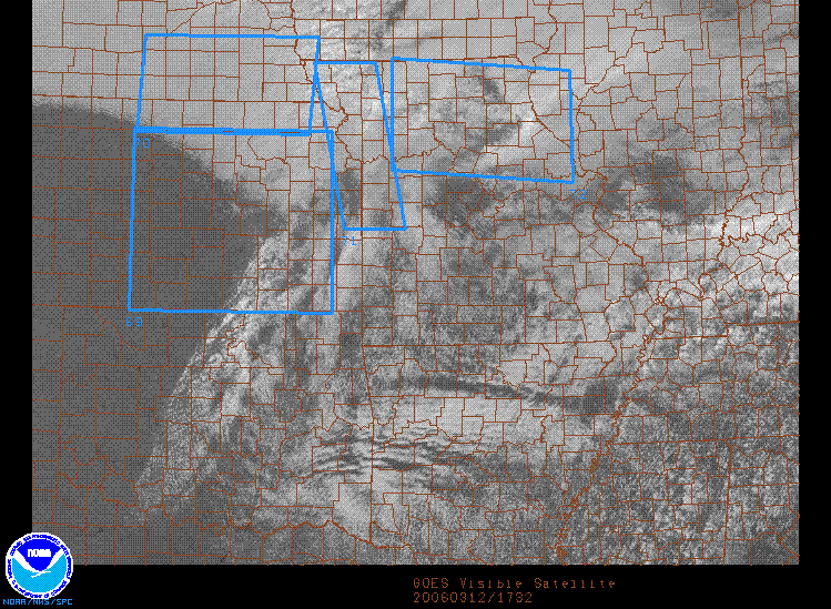
A Closer Regional Look at the mid-Mississippi ValleyIn looking at a satellite image of the area at the time of the storms (shown below, click here or on image for full size) further evidence of the intensity of these storms is clearly seen on the image as the bright white bowed area in the center of the right-most blue watch box.
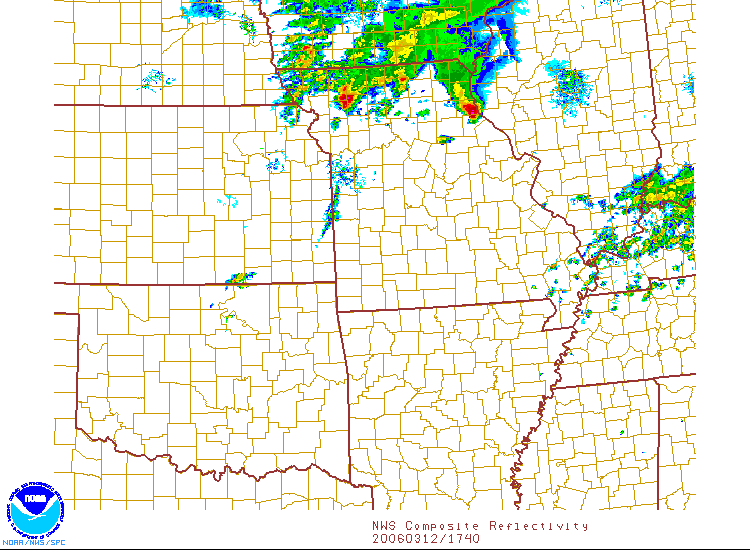
We can see even further confirmation of the strength of these storms by looking at the composite mosaic NEXRAD reflectivity image below (click for full size image). In looking at the image notice the areas of bright red which indicate the most intense areas of storms which also correspond to the brightest white areas on the satellite image above.
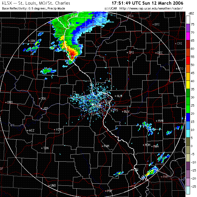
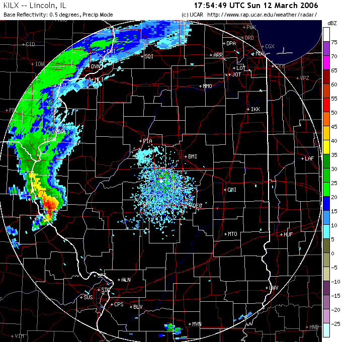
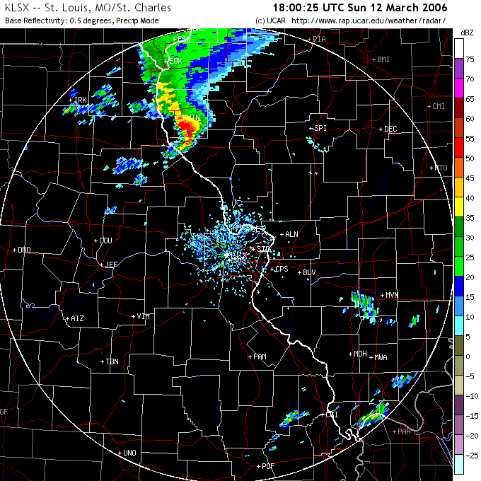
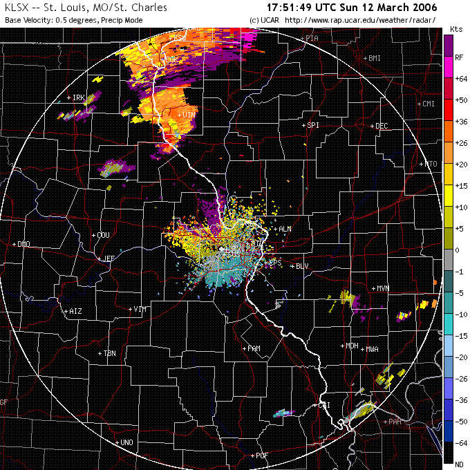
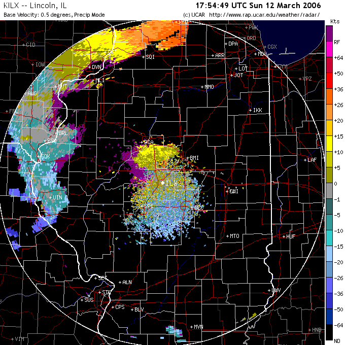
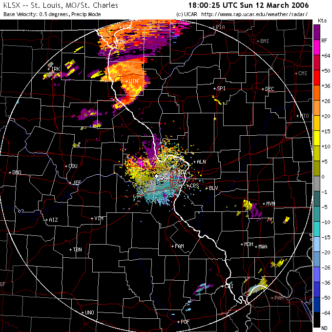
Shown below are a series of 6 images (3 of reflectivity on the top row and 3 of velocity returns on the bottom row) for radar sites at KLSX (St. Louis) and KILX (Lincoln, IL) covering the time period between 1750-1800Z (click on small images for full size versions - all six images are courtesy of NCAR/UCAR). In looking at the large images you can see that on the KLSX base reflectivity image from 1751Z (top left image) the strongest storms are located near UIN (Quincy IL) and that on the corresponding velocity image for that time period below (lower left image) it you can see what may be either a mesocyclone or possibly a TVS (tornado vortex signature) to the south of UIN however at the distance it is from the radar site there is no possibility of this being correct because in order to detect a TVS the storm must be very close to the radar site when it occurs. As you can see on the image the radar site (the site is located at the center of the image) is extremely far away from the potential TVS signature. The possible detection of the Tornado Vortex Signature (TVS) is based on the the rapid change in wind direction and velocity in the area around what would be a tornado. This is indicated on the velocity images by the quick change in colors from blue (which indicates movement towards the radar site) to red (which indicates movement away from the radar site) which is what would appear to be happening over a small area during a tornado due to the rotating nature of the storm. In the center images from 1754Z at the KILX (Lincoln IL) radar site you can see confirmation of the strength of the storms near Quincy IL again by the bright red radar returns on the base reflectivity image (top middle image). On the velocity image (lower middle image) however the possible rotation shown near there by the KLSX radar velocity image from three minutes earlier is not apparent most likely due to the orientation of the storm to the radar site and the distance as mentioned above. Looking at the last set of images taken from the KLSX radar again at 1800Z you can again see strong storms near UIN on the reflectivity image (upper right image) and again a red to blue transition to the SW of UIN on the velocity image (lower right image) which may again indicate rotation in the storm complex in the form of a mesocyclone. The mesocyclone is a rotating column of usually warm and moist air inside a thunderstorm which provides the storm with the "fuel" it needs to grow and continue to exist, sometimes for a very long period of time, possibly as long as 4-6 hours. This long life time not only allows the storms to become potentially quite intense, but to also cover a large area as they move during that time while still maintaining that intensity level. This long life time is most probably what allowed these storms to form far south of the area and remain strong and move over it some time later.
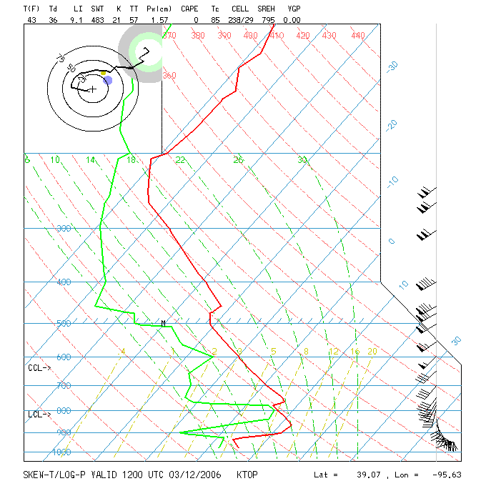
Another area of data we can examine to look at the potential strength of the storms is the stability of the atmosphere itself in the area not only where the storms caused damage but farther south where they formed earlier in the day. For this examination we can use a tool called a skew-T Diagram which shows the temperature, dew point, wind speed and wind direction at various altitudes above the surface of the Earth. These altitudes are generally expressed in terms of pressure levels measured in millibars (abbreviated mb) which higher altitudes represented by lower (and hence smaller) pressure values. Below you will see a skew-T diagram generated by the Topeka, KS weather service office at 12Z on March 12, 2006 (click for larger image). In it you can see (the red line indicates temperature and the green which indicates the dew point) that in the lower portion of the atmosphere the temperature rises as you ascend up to a point just about the 850mb pressure level. Normally however the temperature will fall with increasing altitude, when it does not it's called an inversion and indicates an area of very stable air that would normally prohibit storm formation. One way that the inversion can actually aid in thunderstorm potential is by trapping warm moist air near the ground (think of it as putting a lid on a boiling pot of water), and during the day at some point the temperature at ground level will increase to a point where the temperature is warm enough so that it can rise. When this does occur the air will rise quite rapidly into the cooler air above (like the lid of the pot which will eventually lift off the pot to allow steam to escape), leading to the possible rapid formation of storms. Another item on the image to consider is the upper left item called a hodograph. This image shows the wind speed and direction at various levels of the atmosphere, and when it has a clockwise curving pattern similar to what you see below, this is a good indication that winds in the atmosphere are properly oriented to allow for rotation within any storms that may form, and that rotation is one of the key ingredients for long lasting and potentially strong thunderstorms or tornadoes.
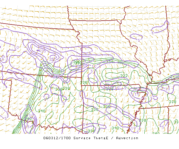
Another set of data items that can show the potential for storm formation and severity are items like theta-e advection, deep moisture convergence, lifted index and the 100mb CAPE graphics images. I'll discuss each of these items and their significance shortly. The following image is a graph of theta-e advection (click for full size image) from 1700Z on March 12, 2006. This image clearly shows the area of warm, moist air (this is what theta-e measures) in the southern Missouri area. The values in green are equivalent potential temperature measured in degrees Kelvin (these values take into account not only the temperature of the air but also the amount of moisture in the air as well) and the purple contours show where these values are increasing or decreasing, the larger the number the bigger the change. The higher the theta-e values the warmer and more moist and thus potentially unstable the air is. As you can see by the image the values in the area of southern Missouri where the storms were initially formed are quite large and indicate a very warm, moist and unstable air mass. This is one of the key ingredients in thunderstorm formation.
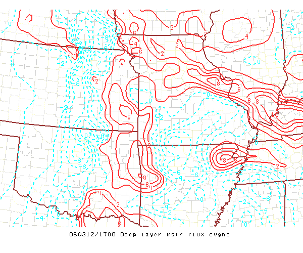
Another item that indicates the potential for and possible severity of thunderstorms is one known as deep moisture convergence. These values show again where warm, moist air is located in an area from the surface to an altitude of about 2km in altitude. In the image below (click for full size) you can see that the highest values are again in the area of southern Missouri with values as high as 8 indicated on the Missouri and Arkansas border. So now we have two items which help to to indicate where strong thunderstorms may form, Theta-e advection and deep moisture convergence. Both are indicating a similar area where there is an abundance of warm, moist air - fuel for strong or severe thunderstorms to form.
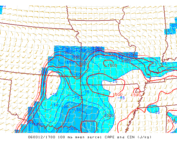
A third item we can look at is what is known as 100mb MLCAPE, which stands for the 100mb mean layer (ML for short which is a fancy way of saying average if you like for the lowest 100mb of the atmosphere) convective available potential energy (i.e. CAPE). Again here, the higher the values the larger the chance for stronger storms. As you can see in the larger image (click to enlarge) the highest values are in the south central Missouri area with the red contours indicating areas with values near or over 1500 J/kg. This image is yet another indictor that the ingredients needed (warm, moist air) are located in this area and available to start the process of forming strong or possibly severe thunderstorms.
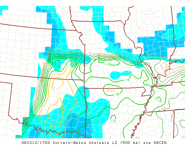
The last item I want to present is an item known as the SB lifted index (SB stands for surface based - which means these values shown are computed based on data starting at the surface of the earth and moving upwards in altitude). This particular value of lifted index is a way to express how unstable the atmosphere is in an area - i.e. how likely it is to allow for the formation of storms and how strong they may be. It compare the current temperature of the atmosphere at an level of 500mb (about 15-18,000' in altitude) and the possible temperature of a parcel or bubble of air if it were raised from the surface and allowed to cool at a standard rate. The lower the lifted index value the more potentially unstable the air is becoming and therefore the greater the chance for strong or severe thunderstorms or possibly tornadoes. As you can see the values in the southern portion of Missouri are in the range of -6 which according to standard criteria indicate strong or severe thunderstorms are probable and tornadoes are possible. Still another indicator that if thunderstorms form they will likely be strong or severe and possibly even lead to the formation of tornadoes as they grow and move.
So, given all the various pieces of data shown above:
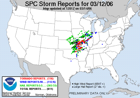
what really did happen on March 12, 2006 at about 17-1800Z near the St. Louis area of the Missouri and Illinois border? The answer is that the weather system that formed to the south in that area of warm, moist air caused an outbreak of severe storms and tornadoes that then moved north into the St. Louis area, arriving about 17-1800Z and at that time became the most intense outbreak of sever weather and tornadoes of 2006. As a result of the intensity of the storms Tornado Warnings were issued beginning at 1124am(1724Z) local time. and damage reports started to be complied by 1210pm (1810Z). When the storms were over the system had produced an incredible number of tornadoes(116), hail reports(383) and high wind damage reports(112) as shown in the graphic below. In looking at the detail compiled after the storm, sadly, 6 people lost their lives and 35 were injured - some seriously.
My Reflections And Observations As A Result of This Weather Event My first reactions to the events that took place on March 12, 2006 was one of sadness for those injured or killed as a result of the storms. To use the words of Professor Grenci from my course from when he was a student and looking at a radar image indicating a tornado "People are dying down there". Clearly this event shows that even with all the technology we have at our disposal and knowledge we have gained about the atmosphere and its properties and actions, we are still entirely incapable of doing anything more than making short range predictions a few hours into the future of the possibility of severe weather and tornadoes occurring in an relatively large area until jut before or right when the events begin to occur. In any case we are completely powerless to do anything to affect the storms once they begin to form and start to march across the landscape possibly destroying virtually everything in their path. At this time all we can do is issue warnings to those in the path of the storms as quickly an accurately as we can and hope they are heard and heeded. Sadly at times they are not, and sometimes even when they are, the results can be tragic as is shown above. This particular outbreak was interesting to me because where I live is not a great deal farther to the north from where the storms caused damage and my own area was affected by similar storms not long before this and again not long after it. As a result of completing this assignment, I have discovered that the time frame available to gather the relevant data, process and analyze it and based on that, potentially issue watches or warnings to the public is often measured in just a few hours at most. Once events begin to occur with the storms to the point when people are at risk may be much shorter than that even, on the order of just a few minutes. Given the huge amounts of data available to a forecaster at the Storm Prediction Center (SPC) I find it fascinating and very impressive that they are able to digest and analyze all this information in the short time periods involved and still come up with rapid and relatively accurate warnings to the public. What I have discovered is that I need to learn more about how the various data items available are relevant in various storm situations and how to quickly interpret them to make sense of what they are showing me and the effects that this translates to in the real environment outside my own window. |
