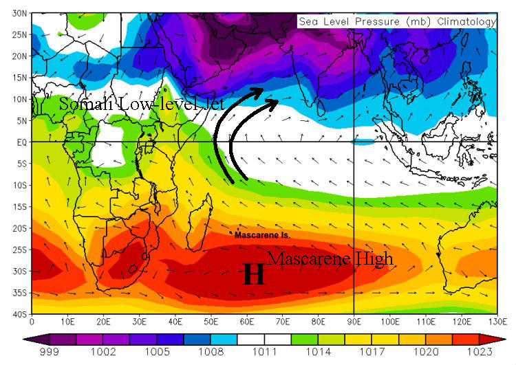
MONSOON PLAYERS

You may be wondering how exactly the start of India's monsoon is defined.  Most meteorologists define it this way:  Starting
May 10, at least five out of the seven meteorological stations in 
Kerala must measure rainfalls of one millimeter or more for two consecutive days. In this case, the monsoon officially begins on the second day.  What triggers this rainfall?  The biggest factor
is the Somali Low-level Jet.

The Somali Low-level Jet (also called the East African Low-level Jet or the cross equatorial jet) is a super moist ribbon of air
at approximately 5,000 feet that gets its start near the Mascarene Islands. There is a subtropical area of high pressure here
just east of southern Africa.  In the southern hemisphere, wind moves around high pressure systems in a counterclockwise
direction, opposite of the northern hemisphere.  As these southeasterly winds cross the equator, they turn to the right, due to the
coriolis force, and become southwesterly winds that flow toward India.  The figure below shows this process very well.


This is a map of mean sea level pressure with wind vectors that shows the mean position of the Mascarene subtropical high in July and
the Somali Low level Jet. The winds turn to the right as they cross the equator, causing a southwest flow over India, courtesy of PSU.


Why is the Somali Low level Jet enhanced during the summer?  When the wind around the Mascarene High reaches Africa,
the flow is blocked by the mountainous terrain. In addition to the Coriolis force, these mountains over Eastern Africa force
the moist air to the east back toward India.  As this wind current flows away from Africa and over the Arabian Sea, upwelling
occurs because the wind exerts a drag on the surface water, setting it in motion.  As the cooler water comes to the surface,
there's a large temperature contrast between the land and sea.  Also, this contrast exists because land heats much more rapidly
than the ocean, especially during the summer when the sun is at its strongest.  This large pressure gradient keeps this jet so
powerful.  Now that the Somali Low level Jet is moving rapidly over the Arabian Sea directly at India, it transports high
theta-e
air into the region, perfect for thunderstorm development.


Another reason why the Indian monsoon starts at the end of May or beginning of June is the onset vortex: a type of subtropical cyclone that forms off the west coast of India.  It's a mid-level low pressure that develops due to strong horizontal shear north of the Somali Low level Jet and 30 degree Celsius sea temperatures. Once formed, the cyclonic winds around the vortex combine with the jet to bring high moisture  into southwest India, suitable for thunderstorms, as shown in the
figure to the right on May 30 this year.  
You can see a slight cyclonic curvature to the clouds off the west coast of India, this year's onset vortex. In most cases, this weather feature signals the start of the
Indian monsoon; however, this turned out to be a very unusual year.
                                                                                                                                    This satellite image shows the exact position of the onset vortex near
                                                                                                                                   
the southwest coast of India at 12Z on May 30, courtesy of SATMOS.


PAGE   1    2    3    4