Mesoscale Discussions & Tornado Watch Boxes
March 12, 2006 Evening Storms
Since we're focusing on the supercell that spawned the F3 tornado during the 04Z hour (10:00 pm CST), we'll go directly to the pertinent Mesoscale Discussions and Tornado Watches issued around this time period for the central Missouri area. There were two tornado watches issued that encompassed this area: TD #73 at11:55 am CST that included "most of Missouri," and TD #77 at 8:40 pm CST that included "much of Missouri." Obviously the second one is closer to our time of focus, but I want to at least touch on the previous watch box and its associated MDs as the situation leads up to our supercell.
First of all, on both watch boxes, you'll see a pretty well-defined line of storms moving out of the watch box area. These are the retreating storms from the afternoon's phase of the outbreak. The evening storms have yet to develop at this point. Hence, the watch.
Below is TD #73. Hickory County is located near the bottom of the box in the center. The accompanying text references several variables in place for development of supercell thunderstorms. This was issued at 3:04 pm CST.
 |
DISCUSSION...RAPID DEVELOPMENT OF SUPERCELL THUNDERSTORMS WILL OCCUR EARLY THIS AFTERNOON AHEAD OF A PARTICULARLY INTENSE UPPER TROUGH AND JET STREAM MOVING INTO CENTRAL U.S. IN ADDITION TO VERY LARGE HAIL...THERE IS THE POTENTIAL FOR DAMAGING LONG TRACK TORNADOES LATER THIS AFTERNOON AND EVENING. STORMS WILL INITIATE VICINITY OF DRY LINE ERN KS AND ADDITIONALLY VICINITY WARM FRONT EXTENDING EWD ACROSS MO INTO IL. |
| Tornado Watch Box #73, issued from 11:50 am until 8:40 pm CST. Hickory County is located toward the bottom of the box in the center. Image from the SPC website. | Excerpt from TD #73 Watch Box discussion. |
The intense upper trough was shown in the synoptic setup page, as the 500 mb Absolute Vorticity map for 04Z (10:00 pm CST). Also shown was the low level jet. So let's take a look at three areas that will give us a clue as to the possibility for supercell and/or tornado development. These charts are all from the SPC Mesoanalysis web page. They are CAPE (Convective Available Potential Energy), 0-6 km Shear, and 0-1 km Helicity. Here they are at 00Z (6:00 pm CST).
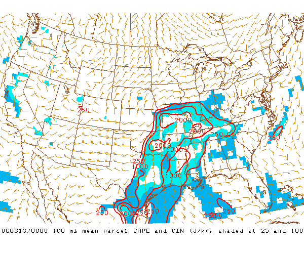 |
This chart shows the values of 100 mb MLCAPE-CIN at 00Z (6:00 pm CST) March 12, 2006. CAPE values are in red and shows as 2000 j/kg for the central Missouri area. These are considered high and favorable for surface-based convection, supercell development, and possible tornadogenesis. The CIN (Convective Inhibition) factor is outlined in the blue shading, and you'll notice that this shading is very sparse in the central Missouri corridor. Image courtesy of the SPC Mesoanalysis Archive web page. |
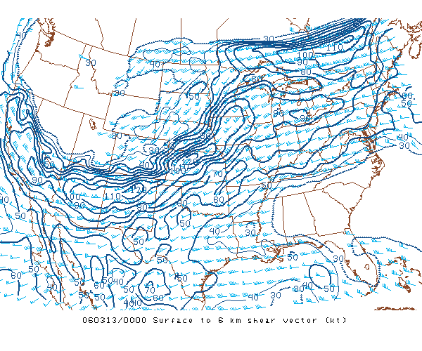 |
This chart shows the surface to 6 km wind shear vector in knots for 00Z (6:00 pm CST) March 12, 2006. The shear values of 60-70 knots for the central Missouri area indicate strong wind shear favorable for supercell development and possible tornadogenesis. Image courtesy of the SPC Mesoanalysis Archive web page. |
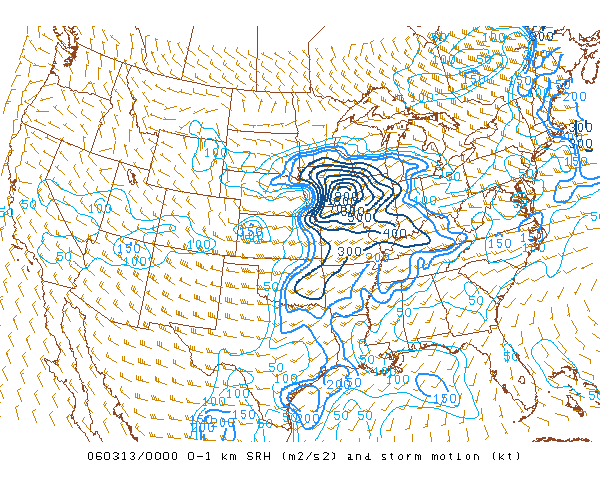 |
This chart shows the surface to 1 km storm relative helicity (bold lines) and storm motion (in knots) values. The value for SRH of 300 in the Missouri area is high and therefore favorable for supercell/tornadogenesis. The storm motion is northeast at 30 knots. Image courtesy of the SPC Mesoanalysis Archive web page. |
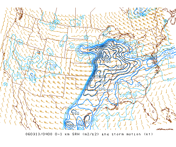
And here they are for 04Z (10:00 pm CST), captured just minutes before the Carson's Corner F3 touched down.
 |
In this 100 mb CAPE-CIN chart, the CIN has risen a bit from 4 hours previous, with the CAPE still reading 1500-2000 j/kg. This indicates the atmosphere had stabilized somewhat from the afternoon round of storms. However, with the other factors present favorable for supercell development and possible tornadogenesis, these values were easily overcome in order for storms to erupt again. Image courtesy of the SPC Mesoanalysis Archive web page. |
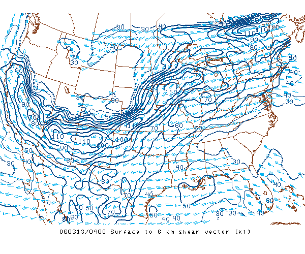 |
This chart of surface to 6 km wind shear is roughly the same as 4 hours prior, still sitting at 60-70 knots over Missouri. Image courtesy of the SPC Mesoanalysis Archive web page. |
|
|
This chart of 0-1 km storm relative helicity and storm motion shows the helicity factor has risen to 500-600, which is explosive for mid-level rotation (tornadogenesis). Image courtesy of the SPC Mesoanalysis Archive web page. |
As defined above, CAPE is the measure of the Convective Available Potential Energy required to spawn thunderstorm/supercell development. CAPE is a proxy for the potential of warm, moist air rising to form convection. High CAPE values are favorable for development of supercells. CIN is the Convective Inhibition of this convection, present when a capping inversion is present in the upper levels of the atmosphere, which must be overcome with surface-based heating in order for the warm, moist air at the surface to rise (quick rising = steep lapse rates) and form convection.
The 0-6 km Shear Vector chart is an indicator of the horizontal vorticity (rate of spin of inflow air) and wind shear from the surface to approximately 500 mb, which is roughly 18,000 feet. Higher values indicate more favorable conditions for supercells to develop, as the shear plays into the mid-level rotation of the mesocyclone, the trademark feature of a supercell. Thunderstorms become more organized and persistent when the magnitude of the vertical wind shear increases.
The 0-1 km SRH (storm relative helicity) and storm motion chart gives us values to measure the rate at which the updraft sucks in the inflow from ground level air (and its vorticity, or rate of spin). Higher values indicate increased possibility for supercells and tornadoes.
I've digressed a bit, but what all of this shows is that the atmosphere was favorable for supercell development and possible tornadoes all afternoon, even though two phases of storm activity had already moved through the area (one phase for the central and lower Missouri area). The Mesoscale Discussions that accompanied TD #73 (MD #259, MD #261, MD #264, MD #267, and MD #269) all continue to reiterate the concern (and relative tornadic cell history) for the severe weather threat throughout the evening. Two excerpts I want to share that zero in on our focus area (close to the Springfield, MO area). From MD #259:
ALONG/SOUTH OF THE WARM FRONT...AMBIENT WARM SECTOR IS CHARACTERIZED BY A RATHER FAVORABLE COMBINATION OF STRONG INSTABILITY/VERTICAL SHEAR FOR A SIGNIFICANT SEVERE THREAT... REFERENCE 18Z SPRINGFIELD MO OBSERVED RAOB. POTENTIAL FOR SUPERCELLS PRODUCING VERY LARGE HAIL/POSSIBLY SIGNIFICANT TORNADOES WILL CONTINUE TO INCREASE IN THE SHORT TERM FROM FAR EASTERN KS INTO WESTERN MO...INCLUDING THE GREATER KANSAS CITY METRO AREA SOUTHWARD TO THE JOPLIN VICINITY.
And from MD #269:
FURTHER WEST...BROKEN STRING OF SCATTERED SUPERCELLS CONTINUE
TO ERUPT FROM NORTH CENTRAL MO INTO EXTREME SW MO AHEAD OF DRYLINE/COLD FRONT.
THIS ACTIVITY WILL CONTINUE TO SPREAD
EASTWARD ACROSS WESTERN/CENTRAL MO TONIGHT...WITH POTENTIAL FOR TORNADOES...PERHAPS
ENHANCED BY CENTRAL MO WARM FRONT AND/OR OUTFLOW BOUNDARY FROM PREVIOUS
CONVECTION. IN ADDITION...VERY LARGE HAIL WILL REMAIN LIKELY WITH THE STRONGER
STORMS...WITH A DAMAGING WIND THREAT
POTENTIALLY EVOLVING/INCREASING LATER THIS EVENING.
When the TD #73 watch box was about to expire, another watch box was issued to replace it (actually issued at 3:44 pm CST), as the threat was still abundant in nearly the whole state of Missouri. TD #77 was issued from 8:40 pm to 4:00 am CST (March 12 - 13). This graphic and accompanying pertinent text are shown below.
 |
DISCUSSION...WIDESPREAD SEVERE STORMS ARE AFFECTING
PARTS OF WESTERN/CENTRAL MO TONIGHT...AS WELL AS PARTS OF NORTHERN
AND CENTRAL IL. THESE AREAS WILL CONTINUE TO BE AFFECTED BY
SUPERCELL STORMS CAPABLE OF VERY LARGE HAIL...DAMAGING WINDS...AND
STRONG TORNADOES. THREAT WILL LIKELY PERSIST MUCH OF THE
NIGHT AS LOW LEVEL JET BECOMES VERY STRONG AND UPPER SYSTEM
APPROACHES. |
| Tornado Watch Box #77, issued from 8:40 pm until 4:00 am CST. Hickory County is located toward the bottom of the box in the center. Image from the SPC website. | Excerpt from TD #77 Watch Box discussion. |
The accompanying MD #273 for this tornado watch box was issued at 11:30 pm CST, and states that the threat is ongoing for tornadic supercells later in the evening. This excerpt ought to wrap up this discussion nicely:
THREAT FOR STRONG/DAMAGING TORNADOES IS EXPECTED TO PERSIST WITH GREATEST THREAT FROM NRN AR NEWD THROUGH CNTRL AND ERN MO INTO CNTRL AND N CNTRL IL NEXT FEW HOURS.
LATE THIS EVENING A
LINE OF SCATTERED SUPERCELLS...SEVERAL OF WHICH ARE STILL PRODUCING
TORNADOES...CONTINUE IN THE PRE-FRONTAL WARM SECTOR FROM PARTS OF N CNTRL IL SWWD THROUGH NERN...CNTRL
AND SRN MO INTO EXTREME NRN AR. LATEST VWP OUT OF ST LOUIS SHOWS 70+ KT
AROUND 1 KM RESULTING IN A VERY LARGE LOW LEVEL HODOGRAPH WITH STORM RELATIVE
HELICITY IN EXCESS OF 600 M2/S2...FAVORABLE FOR STRONG LOW
LEVEL MESOCYCLONE AND TORNADO DEVELOPMENT. THIS LOW LEVEL JET WILL
PERSIST INTO THE OVERNIGHT...CONTRIBUTING TO AN INFLUX OF MOIST
UNSTABLE AIR...AND SHOULD HELP TO MAINTAIN THE SEVERE WEATHER
THREAT EWD THROUGH THE MS VALLEY NEXT SEVERAL HOURS.
ANOTHER LINE HAS
DEVELOPED FARTHER WEST FROM NERN OK NEWD INTO N CNTRL MO. DAMAGING WIND AND
LARGE HAIL ARE LIKELY WITH THIS LINE...BUT ISOLATED TORNADOES ALSO REMAIN POSSIBLE.
Notice in the middle paragraph that they mention the 1 km winds at 70+ knots
(it's increased since our chart at 00Z), SRH > 600 (that's shown on our 04Z
chart above), and the low level jet (shown earlier on te 850 mb chart).
The influx of moist unstable air is what our CAPE chart was measuring (and the
theta-e chart I linked to earlier).
Now I'd like to delve briefly into a couple of forecasting tools that can tell us how supercells will behave and gauge the possibility of the development of tornadoes.