Storm Motion
March 12, 2006 04Z Supercell
Storm relative winds and storm motion are related, as shown previously in the 0-1 km SRH and Storm Motion chart. The 9-11 km SR Winds (storm relative winds) shows us the winds at the anvil level of the storm, which will allow us to see what type of supercell might be forming. This helps to determine if the cell may become tornadic, as some types are more favorable for tornadogenesis than others based upon their structure.
These charts of 9-11 km SR Winds show us that values in the central Missouri area were 50 at 00Z and 40-50 at 04Z. Values of 40-60 knots are indicative of a classic supercell structure, which is favorable for tornado development. According to just this chart alone, the evening was ripe with the threat of tornadoes.
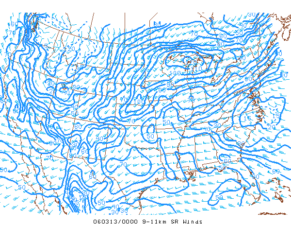 |
| This 9-11 km Storm Relative Winds chart indicates a value of 50 over the central Missouri region, which translates into a classic supercell structure, favorable for tornadogenesis. Image courtesy of the .SPC Mesoanalysis Archive |
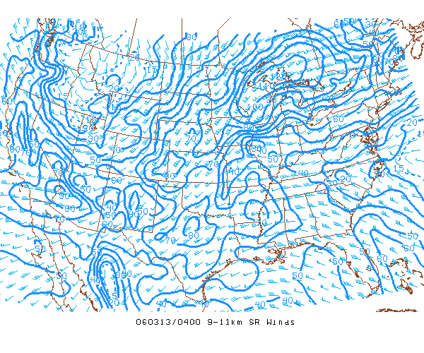 |
| This 9-11 km Storm Relative Winds chart indicates a value of 40-50 for the central Missouri region. This still indicates a classic supercell structure favorable for tornadogenesis. Image courtesy of the SPC Mesoanalysis Archive. |
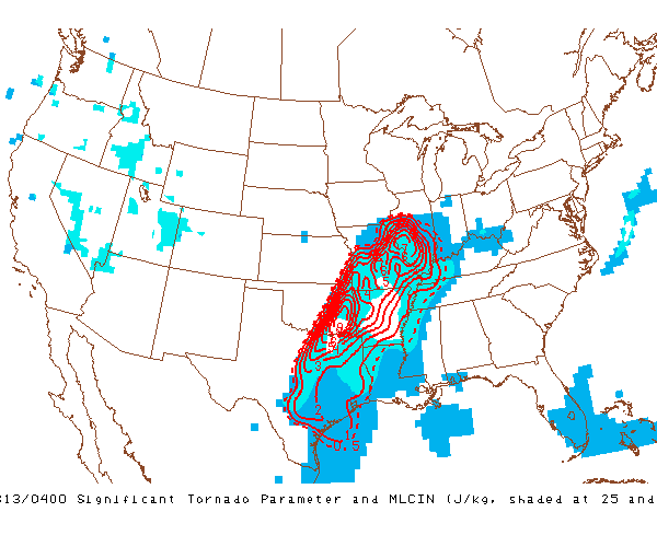
One more tool I'd like to use to show how forecasters can gauge the possibility of supercell/tornadogenesis is the composite index called Significant Tornado. This tool uses a composite (hence the name composite index) of 0-6 km Shear, 0-1 km Helicity, MLCAPE (Mixed Layer CAPE), LCL (Lifting Condensation Level) - effective bulk shear, effective storm relative helicity, 100 mb CAPE and CIN, and 100 mb LCL height (all mean). We've covered the 0-6 km Shear and the 0-1 km Helicity, as well as CAPE and CIN in general. MLCAPE is the measure of CAPE in the lowest part of the atmosphere, but not just at the surface, allowing for a fairer value (i.e. not inflated by high theta-e at ground level). LCL height is important as it outlines the level of the atmosphere where net condensation begins (convection usually occurs here). The lower this height, the more favorable for tornadic supercells. In summary, they've taken vertical wind shear, the potential for mid-level rotation, convective potential vs. convective inhibition present, and the height at which convection usually occurs to come up with a single value to determine the possibility of tornadogenesis. There's a complicated mathematical formula involved which brings all of these factors into play, bringing us the single-digit value. Higher values translate to higher probability of significant tornadoes, assuming all factors are in play within their favorable dimensions (there are other determining factors not used in this formula). The chart below has a value of 5-6 in the central Missouri region - values greater than 1 have been associated with F2 or higher tornadic events. Therefore, the atmosphere was ripe for tornadogenesis in his area at 10:00 pm Sunday night.
 |
|
This chart for Significant Tornado Parameter and MLCIN (Mixed Level Convective Inhibition) is captured for the 04Z hour that encompassed the F3 Carson's Corner tornado. STP values of >1 have been associated with significant tornadoes (F2 or greater). Notice the STP values of 5-6 in the central Missouri region. Image courtesy of the SPC Mesoanalysis Archive. |
For storm motion, we can use the hodograph to determine speed and direction of the supercell. Below is a charted hodograph for 00Z (hodograph and Skew-T from the University of Wyoming website). The annotation on this chart illustrates the Rasmussen method for determining the storm motion vector based on the vertical wind shear profile. This profile is outlined by the hodograph.