The Carson's Corner F3 - Tornadogenesis at Pomme de Terre Lake
The Story
Carson's Corner - makes one think of Uncle Joe on Petticoat
Junction, sitting on the porch napping (his name was Joe Carson).
Actually, Carson's Corner is a very small place, literally a corner at the
intersection of Highways 54 and 64, with businesses that service a neighborhood
of houses at Pomme de Terre Lake in south-central Missouri. Included in
this community of businesses are a church, boat and RV storage lot, two
general/convenience stores, a mechanic's garage, a restaurant, a motel, and a
covered boat and RV storage place. A few houses are peppered in with these
businesses, and on one corner all by itself sits a tiny smoker trailer with BBQ
written on it.
At about a quarter past 10:00 pm on a Sunday night (March 12, 2006), Carson's Corner experienced an F3 tornado that touched down 5 miles west of Pittsburg, where it strengthened to F2 and damaged and/or destroyed several homes and a storage facility in a small community, crossed the lake, damaging campsites as it traveled northeast, and strengthened to F3 at Carson's Corner, where it also spent its fury, weakening to an F1 before lifting 3 miles east of Hermitage. The damage report from the National Weather Service in Springfield states that the tornado was about a quarter mile wide and its path approximately 9 miles long.
It so happens I have relatives who live just across the dam from Carson's Corner (Judy and Lee, affectionately known as "the parents"), and they spent that night sheltered in the closet under the stairs. When the tornado passed by, they had the tv on loud so they could hear it in the closet, so they didn't hear any roar. Shortly after the tornado passed by, they lost power, which didn't return until the next day. Lee was told by his next door neighbor later that he'd been standing outside and saw the funnel cross the lake just above the water (they live out on one of the points). My question was what was he doing outside watching it! Upon reading the SPC Storm Report the next day, I came across the Carson's Corner damage entry and immediately called them (which is when I found all of this out). They took a drive by there (they had to go the long way around the lake because the road across the dam leading into Carson's Corner was closed due to debris) and called to tell me "it's gone." The day after that, they got some damage photos that clearly show the devastation an F3 tornado can do. [I should also note here that the neighborhood adjacent to Carson's Corner was where my mother lived for 3 years after leaving my childhood home in Dallas. We lost her 5 years ago. She would've had a field day with this, as it would have become one of her 'stories' - I can hear it now, "the tornada that came right by my house!"]
Of all the businesses and buildings mentioned in the first paragraph, none were left untouched except the church and the BBQ trailer. The little pine tree next to it was snapped in two. One house was merely twisted on its foundation. All other buildings sustained anywhere from major damage to total destruction. The pastor's house behind the church sustained major damage and was the first building up the hill from the damsite park that was annihilated at the point as the tornado came from across the lake (the storm report states that the church was damaged, but it was not that I could see, only the pastor's house). One store was completely destroyed and pushed back into the owners' house behind it. The other store was left roofless. The garage was gone except for the lift, the restaurant heavily damaged, and one of the motel buildings was left roofless. The covered boat and RV storage facility was completely destroyed, and boats, trailers and RVs were twisted and turned every which way. Many of the boats in the storage lot were also flattened and/or twisted. The house across Highway 64 took a full frontal hit, and a twisted mass of metal down the hill behind the house looks like what may have been their brand new RV. One of the photos shows an RV that was pretty well battered, though not twisted or flattened, and has the classic 2X4 projectiles sticking out of one end. I went down there 6 days after the event and took more damage photos (here, here and here ). By then cleanup was well underway, and as you drove the countryside, you could see different columns of smoke at various points on the horizon where debris was being burned. And all of those huge, beautiful trees were snapped and twisted everywhere, especially noticeable in the damsite park, where it will take a long time to grow the shade back.
As I walked around taking pictures here, I noted the various odd items scattered on the ground around me. I note them here for the sheer randomness and simple daily life they represent: an empty knife sheath, a partial packet of cold tablets, a 4 of diamonds playing card, a doll's head with a pearl crown, a blue shark toy with wheels, a child's blanket with one of the popular kid's designs (maybe Sesame Street?), a green hibachi, a glass cut candle, a red tool box, one Budweiser waterski, a box fan, two hula hoops, and a wool cap. The hibachi, candle, tool box and waterski were surprisingly undamaged. The 4 of diamonds actually indicates good fortune monetarily or materialistically, which is ironic. Also ironic is the fact that in the pictures the telephone poles and wires appear to be untouched (with the possible exception of the replacement of one pole).
What I didn't capture on film (because it would not have been the right thing to do) was the damage to the homes and storage facility in Pittsburg, across the lake. We found this by Judy's instinct, as we knew only that damage was reported off of J Highway somewhere. She had a feeling "it was down by The Outpost," a little store that services one of the lake communities, and as we drove into the community, we found the damage. Houses and mobile homes were either heavily damaged or destroyed, or sustained merely a twisted or broken tv antenna. The community was very close together, which made it surprising for there to be an undamaged house next to a foundation. The tornado was F1-F2 at this point, having just begun its journey. What struck me were a couple of families who were making a day of burning their debris - a Blazer was pulled up to one of the foundations, with food items on a tv tray. Across the road from this was half a house left, and next door to these foundations a woman was watching from her deck, her house completely untouched. We drove down another road and were able to trace the damage as it moved northeast through the trees, and came to another little community of about 6-8 mobile homes. One green mobile home was tipped on its side and a truck camper shell was hanging up in a tree. I did capture this on film.
|
|
|
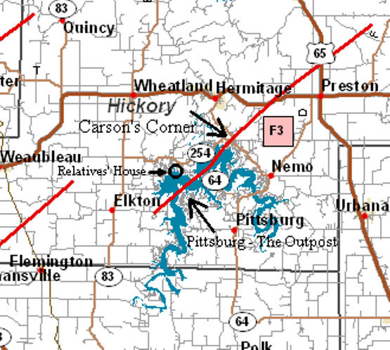
The damage path of the tornado that touched down 3 miles east of Pittsburg and traveled 9 miles to 3 miles east of Hermitage. It crossed the lake and strengthened to an F3 at Carson's Corner. I've annotated where the little community by The Outpost and Carson's Corner are located, as well as my relatives' house, which is the last house at the tip of the point circled. |
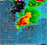
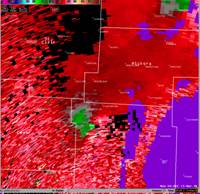
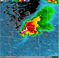
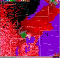
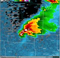
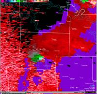
I also took excerpts from the Springfield NWS Storm Report that are pertinent to Carson's Corner. Please note the radar images below that correspond with the tornado that followed the path outlined in the illustration above.
|
||||||
|
Note the prominent hook echo and hail core (left sequence of Doppler radar images) within the supercell that was carrying the F3 tornado. On the right, the green and red couplet that illustrates the presence of the mesocyclone is also prominent within the sequence of Doppler velocity images. These images and this excerpt came from the storm report on the NWS Springfield, MO - Home Page. |
||||||
|
Tornado 4: F-Scale: F3 near Carsons Corner Path Length: ~9 miles Width: 1/4 mile Time: 1017- 1035 P.M. A
fourth tornado track occurred from five miles west of Pittsburg Missouri
(Hickory county)...which is also on the southwest shore of Pomme de
Terre lake...to three miles east of Hermitage Missouri. This was by far
the most intense tornado...reaching f3 intensity across the This tornado touched down south of the Pomme de Terre golf course and moved northeast across the southwest corner of Pomme de Terre lake. Once on land...the tornado moved about 4 miles northwest of Pittsburg Missouri and intensified to f2. There was severe damage to numerous homes and mobile homes. The tornado continued across the lake and crossed land again near damsite park...where it leveled a camping area and destroyed numerous unoccupied campers. The tornado moved northeast from damsite park as an f3 and crossed the Carsons corner area damaging a church and destroying two stores...numerous buildings...part of a hotel...and numerous vehicles...boats and campers. The tornado crossed highway 64 and severely damaged a home. The tornado continued northeast as an f1 and finally lifted three miles east of Hermitage Missouri. [I note again that the statement that the church was damaged was actually not true, it was the pastor's house behind the church that sustained major structural damage.] |
Now that I've told you the story from the human side, it's now time to tell you from a weather forecasting point of view. First I'll cover the synoptic scale setup of the outbreak, which I will borrow heavily from The Heartland Tornado Outbreak, then I'll break down some of the components of 'supercell tornadogenesis' which means how this supercell came to spawn these tornadoes.
Synoptic Overview of March 12, 2006
Mesoscale Discussions and Tornado Watch Boxes
Damage Photos - Carson's Corner - March 14, 2006 (2 days later)
Damage Photos - Carson's Corner - March 18, 2006 (6 days later)
Damage Photos - Carson's Corner - March 18, 2006 part 2
Damage Photos - Damsite Park & Pittsburg - March 18, 2006 (6 days later)