Synoptic Overview
March 12, 2006 Outbreak
The severe weather outbreak for Sunday, March 12 had been a topic of concern for several days prior, both by the SPC and the local meteorologists. The expectation for the weekend was that there would be severe storms on Saturday (and there were), followed by even more severe storms (in number and magnitude) for Sunday. The Day 1 Convective Outlook from the SPC for 12:03 am CST indicated this risk in relation to a frontal boundary and strong south-southwesterly low level jet slated to develop in the afternoon.
...THERE
IS A HIGH RISK OF SVR TSTMS FOR THIS AFTERNOON AND EVENING ACROSS PARTS OF
CENTRAL/NRN MO INTO SERN IA AND PARTS OF WRN/CENTRAL
IL...
...THERE IS A MDT RISK OF SVR TSTMS EXTENDING FROM AR NWD TO SRN IA
AND EWD INTO THE LOWER OH RIVER VALLEY...
...THERE IS A SLGT RISK OF SVR TSTMS EXTENDING FROM NERN TX TO THE
MID MS/OH RIVER VALLEYS AND SRN GREAT LAKES REGION...
...SIGNIFICANT OUTBREAK OF
TORNADOES IS FORECAST THIS AFTERNOON AND EVENING ACROSS PARTS OF THE LOWER MO
AND MID MS RIVER VALLEYS...
STRONG MID/UPPER LEVEL
TROUGH WITH 100+ KT MID LEVEL JET... CURRENTLY MOVING EWD ACROSS
THE LOWER CO RIVER VALLEY...WILL TRACK
NEWD OVER THE CENTRAL/SRN PLAINS TODAY REACHING THE WRN GREAT LAKES
REGION BY 12Z MONDAY. 60-120 METER HEIGHT FALLS EXPECTED WITH THIS
TROUGH AS IT TRACKS NEWD WILL AID IN THE
DEVELOPMENT OF A STRONG SSWLY LLJ /50+
KT/ FROM THE ARKLATEX REGION TO THE MID MS RIVER
VALLEY BY THIS
AFTERNOON. FURTHER
STRENGTHENING /60-80 KT/ OF THIS LLJ IS EXPECTED SECOND HALF OF FORECAST PERIOD
AS IT VEERS TO SWLY
FROM THE MID MS RIVER VALLEY TOWARD THE UPPER OH RIVER VALLEY/
LOWER GREAT LAKES REGION.
The storms that erupted throughout that Sunday came in three phases. There were some morning elevated convective storms north of the warm front boundary in eastern/northeastern Kansas and northwestern Missouri which produced a few tornadoes. The warm front then moved north and with some afternoon heating, as well as the approaching trough and LLJ, a second wave of storms erupted in eastern Kansas and central Missouri just after the lunch hour. These storms were more severe, spawning numerous tornadoes and a couple of fatalities. In the Convective Outlook excerpt above, note that this low level jet was predicted to strengthen for the 'second half of the forecast period,' which puts it right in our focus area for the Carson's Corner F3. This encompasses the third wave of storms with the same intense severity as the second wave, which erupted around sunset and continued through the later evening hours. Our focus area is for 10:00 pm CST (04Z March 13) in the central Missouri area.
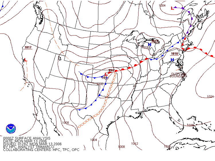
By 6:00 pm CST (00Z March 13) the current surface analysis prominently showed the low pressure system and dry line setup across the midwestern Great Plains.
 |
|
Current Surface Analysis for 00Z March 13, 2006 (6:00 pm CST March 12). This clearly shows the low pressure system and dry line setup over the midwestern Great Plains. Image courtesy of Hydrometeorological Prediction Center. |
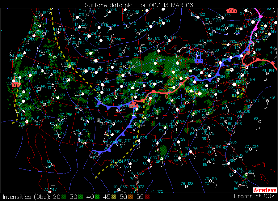
For the same time, the surface chart below shows the warm, moist air in place in the warm sector (east of the dry line), as indicated by the high dewpoints in Missouri, Kansas and Arkansas.
 |
|
This surface plot, also for 6:00 pm CST March 12 (00Z March 13) shows the low pressure system and dry line set up as well as temperatures and dewpoints. Notice the high dewpoints in the warm sector Missouri, Kansas, Arkansas, and the noticeably lower dewpoints behind the dry line and frontal boundary. Warm, moist air is one of the key ingredients for supercell tornadogenesis. Image from the Unisys website. |
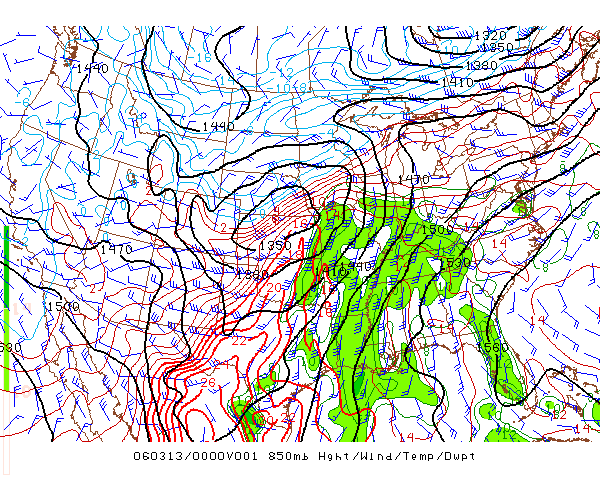
This illustration below is of the low level jet as shown by the wind profile at 850 mb, or the lower levels of the atmosphere. Note the strength of the winds at 50 knots right at the Kansas/Missouri border. Also, these strong winds near the surface are coming straight from the Gulf of Mexico, bringing in that warm, moist tropical air. Thus, higher dewpoints, as shown in the Surface Analysis above (theta-e advection). At 04Z (10:00 pm CST) the winds are even stronger through the central Missouri corridor.
 |
|
This image shows the advection of warm, moist air from the Gulf of Mexico on the low-level jet. Note the 50 knot wind barbs right at the Kansas/Missouri border. This theta-e advection translates into the higher dewpoints conducive to supercell development. This image captures conditions at 6:00 pm CST March 12 (00Z March 13), four hours prior to the Carsons' Corner F3. Courtesy of the SPC's Archive page. |
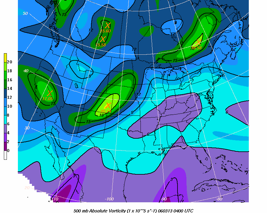
The chart below illustrates the potent 500 mb trough mentioned in the SPC Day 1 Convective Outlook. It's placement in eastern Colorado puts it in the perfect position to affect the Kansas/Missouri area. The vort max is what's bringing the vorticity - atmospheric spin - to the equation for tornadic supercells.
 |
|
The chart of 500 mb Absolute Vorticity showing the potent vort max over eastern Colorado, just east of the low pressure system. This trough was one of the catalysts, as mentioned in the SPC Day 1 Convective Outlook above, that helped feed the outbreak of supercells and tornadoes on the evening of March 12, 2006. This chart was captured for conditions at 10:00 pm CST (04Z March 13) which was approximately 15 minutes prior to the Carson's Corner F3 touchdown. Courtesy of Ohio State University. |
The Convective Outlook for 6:29 am CST Sunday morning gives us another clue as to what was expected for this region in the later afternoon and especially after sundown.
FARTHER SOUTH INTO ERN OK AND NERN TX...INITIATION SHOULD BE
DRIVEN BY HEATING AND CONVERGENCE ALONG AND AHEAD OF DRY LINE AS CAPPING
HOLDS FOR MUCH OF THE DAY. THOUGH THIS REGION WILL REMAIN
REMOVED FROM GREATEST LARGE SCALE ASCENT...FORECAST SOUNDINGS INDICATE A
VERY VOLATILE COMBINATION OF 2000+ J/KG MLCAPES AND 50+ KT
EFFECTIVE BULK SHEAR. IN ADDITION...STORMS SHOULD REMAIN DISCRETE.
THEREFORE...TORNADIC
SUPERCELL THREAT...INCLUDING THE THREAT OF LONG-LIVED TORNADOES AND VERY LARGE
HAIL WILL SPREAD ACROSS SRN MO/AR AND INTO THE LOWER OH RIVER VALLEY WELL AFTER DARK.
And from the 2:04 pm CST Convective Outlook (the last one issued in the archives) the threat for supercells and tornadoes for the rest of the evening hours was predicted to continue southwest of the dry line - which includes the central Missouri area where Carson's Corner is located.
FROM THE EVENING INTO
THE OVERNIGHT HOURS...CONVECTION IS EXPECTED TO CONSOLIDATE INTO ONE OR MORE
BANDS OR CLUSTERS OF SEVERE STORMS
ALONG/AHEAD OF THE ADVANCING COLD FRONT AS THEY MOVE EWD TOWARD THE
MS VALLEY. ALTHOUGH THE SEVERE THREAT MAY TRANSITION TO PRIMARILY
DAMAGING WINDS AND HAIL AFTER 06Z...THE STRENGTHENING LOW LEVEL JET AND
RESULTANT INCREASE IN LOW LEVEL SHEAR/HELICITY
SUGGESTS A CONTINUED THREAT FOR ISOLATED
TORNADOES WITH BOWS OR EMBEDDED SUPERCELLS WITHIN QUASI-LINEAR SEGMENTS.
There are a number of charts and graphs I can put up to show the variables referenced in the Convective Outlooks, such as wind shear, helicity, MLCAPE, etc. However, I believe the charts above give an idea of the synoptic setup for the severe storms to develop. On that note, we can continue on to focus on the Carson's Corner cell.