Caribou, ME KCAR
Forecasting Week of 10/31/06
- 11/4/06
Introduction
For our fourth ePortfolio assignment, we were given the task of
elaborating on our Weather Roundup, which is the recap of the week's weather
events for the week we were Weather Briefer. My week was October 30th
through November 4th for Caribou, ME. My original Weather Roundup page is
linked following the Caribou climatology below, though I give a brief overview
of the week's weather after that.
In addition, we as a class were faced with many challenges
during the second week of Caribou. These challenges included
precipitation, winds, and cloud cover. I've elaborated a bit on each of
these challenges on the following page, with a brief summary of how we handled
forecasting for these situations.
And finally, the last page of this piece contains my reflections
about this class and the certificate program, now that I've reached the end of
it. I've looked back through my previous class reflections and determined
the area where I've grown the most, and tracked that growth through the four
classes of the program. In closing, I've shared my philosophy about
weather and forecasting, which has formed based on my experiences while in the
program.
And now, a little about Caribou and a summary of the synoptic
weather pattern and weather events of my week as weather briefer.
Climatology of Caribou ME
Caribou is located in the far northeast corner of the state of
Maine. The Caribou Municipal Airport (KCAR) sits at roughly the same
elevation as the surrounding hills, 626 feet. Though the Atlantic Ocean is
150 miles to the east, Caribou isn't much affected by its proximity,
experiencing a mostly continental climate. Continental polar (cP) and
continental arctic (cA) fronts bring sub-zero temperatures and strong
northwesterly winds in winter. In autumn, which is when we were
forecasting, the climate calls for mostly sunny, warm days and cool, chilly
nights. In October, winds are predominately south-southwest at 3-5 knots,
kicking up to 5-8 knot west-northwest winds with frontal passages. In
November, the winds change to predominately northwest-west at 5-8 knots, with
3-5 knot south-southwest/southeast winds ahead of the fronts. The winds
pick up with the seasonal transition due to increasing temperature gradients as
the cold fronts come through, which also bring regular precipitation to the
area, average normal amount being 0.10 inches.
Though a warm front and cold front from a low pressure system
came through Caribou at the beginning of our forecast week, the system was
moisture-starved and brought little precipitation to the area. Most of the
heavier precipitation with the system stayed south of Caribou. The maximum
sustained winds throughout the week remained high, though MOS predicted lighter
winds. The sunny, warm days and cool, chilly nights were greatly affected
by the frontal system, WAA and CAA associated with the front, cloud cover and
the winds. All in all, this week was not anything like normal climatology.
The original
Weather Roundup
for my week as weather briefer is summarized below. I've honed it down to
the basic synoptic weather pattern and brief summary of events for each of the
four days we forecast for. Verification data can be
seen in the table below for the week's high and low temperatures,
maximum sustained winds, precipitation, and the climatological norms for
these variables. I've made an additional
table with the MOS comparisons and my forecast to compare with the norms and
actuals listed below.
| Timeframe |
Actual
High |
Norm
High |
Actual
Low |
Norm
Low |
Max
Sustd Wds |
Actual
Precip |
Norm
Precip |
| 06Z 10/31-06Z 11/1 |
41 |
45 |
31 |
30 |
16 |
0.02 |
0.10 |
| 06Z 11/1-06Z 11/2 |
49 |
44 |
30 |
30 |
17 |
0.03 |
0.10 |
| 06Z 11/2-06Z 11/3 |
43 |
44 |
27 |
29 |
12 |
T 0.00 |
0.10 |
| 06Z 11/3-06Z 11/4 |
39 |
43 |
22 |
29 |
17 |
0.00 |
0.10 |
Synoptic Weather Pattern and
Summary of Events
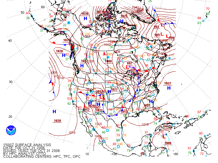
On Tuesday 10/31,
Caribou was finally out from under the influence of the low pressure
system that had passed to its northeast. A high pressure ridge was
in place with a westerly flow. Winds were moderate and
temperatures were cooler than climatological norms. A warm front was
approaching from the south which brought
cloud cover to the area.
As the warm front passed, winds increased to 16 knots due to the increasing
pressure gradient, and precipitation of 0.02 inches occurred at Caribou.
The
meteogram for 06z-06z 10/31-11/1 shows the clouds clearing by 12Z 10/31 and
a low of 32°F, then clouds moved back in by 18Z-19Z 10/31, winds calmed and a
high of 41°F was reached, then the wind shifted to the south-southeast and
precipitation occurred by 23Z 10/31.
 |
| This surface analysis valid 15Z 10/31 shows the low pressure
system to the northeast of Caribou and the high pressure ridge
extending from offshore across Caribou into eastern Canada.
Note the warm front approaching from the south. Image from
the
Hydrometeorological Prediction Center (HPC). |
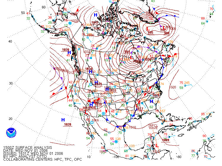
On Wednesday 11/1, the warm
front was located to the northeast and the cold front had passed to the
east of Caribou. Clearing allowed for solar heating, which brought
the temperature up above climatological norms, but weak cold air advection
arrived in the afternoon. The strong pressure gradient still in
place kept the winds at 17 knots. The
meteogram for 06z-06z
11/1-11/2 shows the south winds and cloudy conditions through 11Z, with
rain at 06Z-07Z 11/1, then clearing skies by 12Z with a wind shift to
the west, winds pick up, and temperatures begin to climb by 13Z 11/1.
 |
| This surface analysis valid 15Z 11/1 shows the location of
the low pressure system and its warm and cold frontal
boundaries. Caribou is just west of the cold front and
southwest of the warm front and occluded front triangle.
Image from the
Hydrometeorological Prediction Center (HPC) |
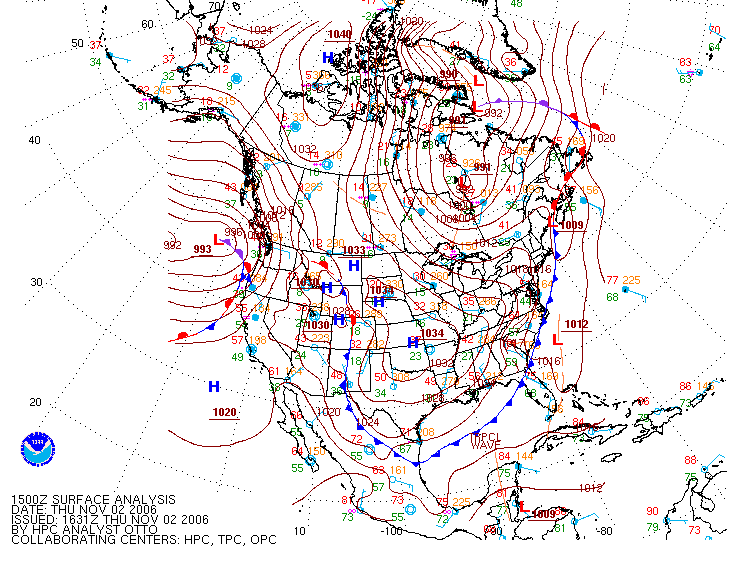
On Thursday 11/2, the
frontal boundary remained just offshore, keeping a continued chance of
showers (a trace of precipitation was recorded) and higher winds (12
knots) in the area. The temperatures were starting to rebound
closer to climatological norms. The
meteogram for 06z-06z
11/2-11/3 shows clouds moving in by 07Z-08Z where the low dipped to
29°F, winds picking back up from the southwest-south at 09Z, skies
clearing again by 13Z with winds more westerly, the high climbs to 43°F
at 19Z, and there is intermittent cloud cover at 23Z 11/2, 02Z 11/3, and
04Z 11/3.
 |
| This surface analysis valid 15Z 11/2 shows the warm/cold
frontal boundary sitting offshore along the entire eastern
coast. Note the low pressure gradient now poised to
affect the Caribou area. Image from the
Hydrometeorological Prediction Center (HPC) |
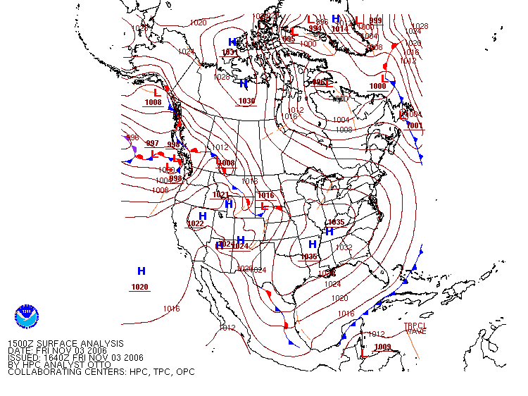
By Friday 11/3, the fronts
had moved on and a high pressure ridge was building, bringing westerly
flow. Colder air moved in to bring the temperatures down once
more. Winds were again higher than normal at 17 knots. The
meteogram for 06z-06z 11/3-11/4 shows the clear skies and light
southwest winds up to 11Z where the low dips to 22°F, then some high
clouds move in briefly, skies mostly clear at 15Z-16Z, but clouds move
back in and winds become northwesterly by 16Z, with the high temperature
of 37°F reached at 18Z 11/3.
 |
| This surface analysis valid 15Z 11/3 shows the low pressure
system and its accompanying frontal boundaries moved
considerably northeast of Caribou, and a high pressure ridge
building over the area. Image from the
Hydrometeorological Prediction Center (HPC) |
A
table with the three MOS model forecasts in comparison to the norms and
actuals points out where MOS busted on temperatures and winds. I also included my
forecast for each day. From this table you can see the
challenges that presented themselves during this week - the winds vs. MOS
predictions, the precipitation amounts for Days 1 and 2, and the high and low
temperatures for Days 1 and 2.
Challenges
Reflections
