Grand Junction, CO KGJT
Grand Junction, CO is located in the Grand
Valley high desert at 4,800 ft above sea level. It's surrounded by
mountains and is subject to valley breezes. Since it sits in the
high desert, precipitation is minimal, with snowfall melting quickly in
winter. Temperatures are milder than what one would expect in
Colorado, with the summer range of 60s-90s and the winter range of
20s-50s for norms. However, for our first forecasting period, a
potent Arctic air mass with record snows came through and cast all the
norms to the winds. And those winds proved to be one of our
biggest challenges for this city - down-valley winds and temperature
inversions. However, the effects of a strong arctic cold front
behind a high-precipitation polar cold front proved to be the catalyst
for our lesson learned. MOS could not foresee the snowpack of
record proportions nor how it would keep the temperatures so frigid.
Forecast Week 1 for Grand Junction,
CO KGJT - Week of November 27th
Only one lesson learned required for this
city!!
Forecast Period 06Z 11/30 - 06Z 12/1
This Lesson Learned had to do with how trapped arctic air
in a valley, especially when sitting over snowpack, can bust the MOS
forecast high temperature by as much as 12 degrees Fahrenheit. The
trapped arctic air creates a temperature inversion, wherein the colder
air at the surface lies under a layer of warmer air (the environment
warms with increasing altitude, causing air parcels to sink back down to
their equilibrium level). This creates a stable environment.
The sounding below illustrates the temperature inversion through a deep
layer of the atmosphere at 12Z on 12/1/06.
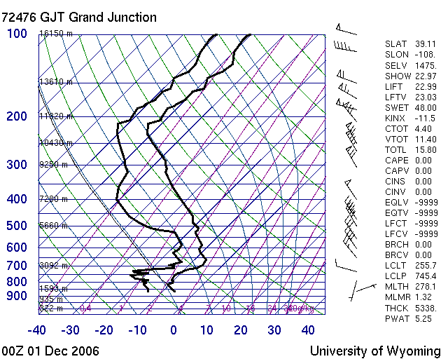 |
| This Skew-T/Log P diagram
(sounding) from the
University of Wyoming shows the deep temperature inversion in
place at 00Z on 12/1/06 (5:00 pm MST 11/30/06). The signature
of the inversion (environment warming with altitude) is shown by the
right-hand line moving to the right (warmer temperatures) as it
climbs up the chart (climbs in altitude). This temperature
inversion occurs fairly deep into the troposphere, as witnessed by
the large jog over to approximately 660 mb. |
Since GJT saw a
record 3.9 inches of snow, the arctic air sitting over this
snowpack remained colder, causing high temperatures to be
very low.
MOS for
11/29 did not account for the snowpack, nor for the arctic air to become
trapped in the valley, causing one model to forecast a high 13 degrees
above what actually occurred (NGM forecast 34°F for 11/30, actual was 21°F).
The other models were too high, as well, though not by this much:
ETA forecast 31°F and GFS forecast 27°F. The dynamic models are
known to move low-level cold air from a cA air mass (continental
Arctic) out more quickly than it typically does, and so does not
tend to account for it. However, a forecaster could look at the high
temperatures behind the front (see surface analysis below) to see what
kind of effect the arctic air mass would have.
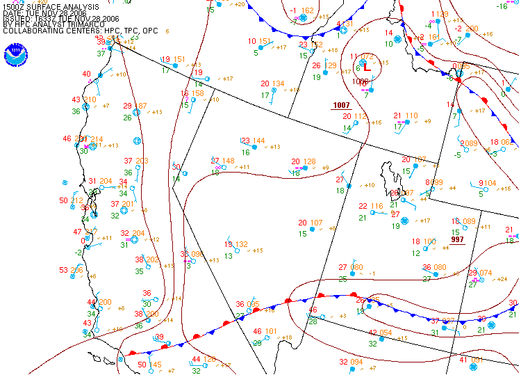 |
| This surface analysis plot from the
Storm Prediction Center shows the temperatures behind the
frontal boundary on 11/28 (image valid at 15Z 11/28/06). Note in the upper right corner the
temperature of 18°F at Grand Junction
(in front of the stationary frontal boundary) and the temperature of
1°F to its north behind the stationary frontal boundary. This
is an indication of the strength of the arctic air mass. Of
note is that a cold front had just passed through GJT, which was the
catalyst for the 3.9" of snow. That frontal boundary can still
be seen down in southern Arizona-New Mexico. |
This same scenario affected the low
temperatures, as well. MOS predicted 7/7/5 (NGM/ETA/GFS) lows for
the forecast period 11/30-12/1, and the actual low temperature came in at 3°F.
Again, the cold arctic air was trapped in the valley (under the deep
temperature inversion) and this air was sitting over the snowpack.
The actuals for 06Z 11/30 - 06Z 12/1 can be found on the
Climate Report
and
METARS for the forecasting period. Of interest, and which
spurred much discourse on the boards, was the fact that in spite of the
deep temperature inversion and the snowpack, the down-valley winds were
able to kick in with some momentum at 15 knots, which ordinarily would
not occur under those conditions. It was determined that the
down-valley winds were a result of the terrain, which enabled them to
overcome the inversion and snowpack variables.
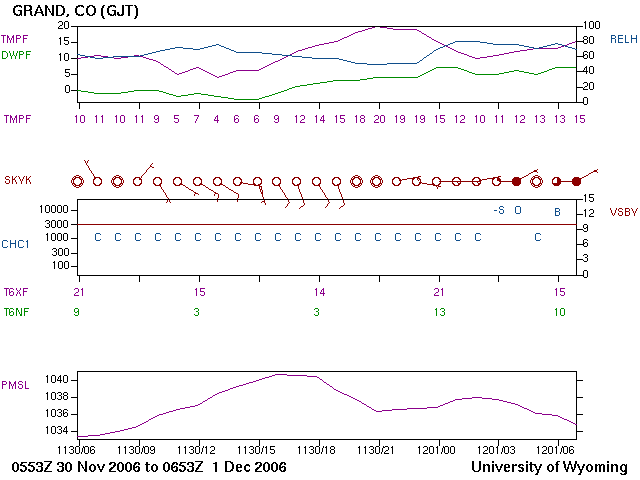 |
| This meteogram from the
University of Wyoming shows the stats for the forecast period
06Z 11/30/06 through 06Z 12/1/06. The 3°F
low occurred between 13Z-14Z (note the 4 at 13Z and the 6 at 14Z).
The high of 21°F occurred between 21Z-22Z (note the 20 at 21Z and
the 19 at 22Z). The down-valley winds occurred in the 16Z-19Z
timeframe, where the wind barbs show a southeast wind at 10 knots. |
The next day (forecasting period 06Z
12/1/06 - 06Z 12/2/06)
MOS did the same thing, forecasting roughly 10 degrees too high for the
high temperature. MOS went 34/38/32 (NGM/ETA/GFS) for the high,
and the actual came in at 26ºF (which can be seen on the
Climate Report
and
METARS for 12/1). For the low temperature, however, MOS tended
to have more of a handle on its forecast, predicting 12/17/9 (NGM/ETA/GFS)
with actual low temperature of 13°F. This is illustrated on the
meteogram below.
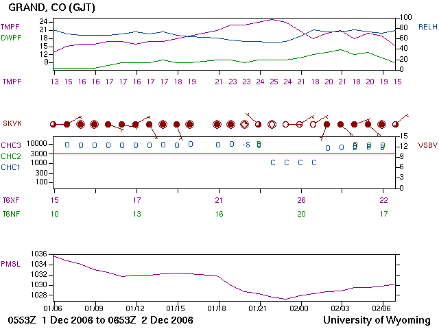 |
| This meteogram from the
University of Wyoming shows the stats for the forecast period
06Z 12/1 - 06Z 12/2. Note the high of 25°F
at 22Z (actual 26°F between 22Z-23Z)
and the low of 13°F (actual) at 06Z 12/1. Except for around
the time of the high temperature, skies were overcast, as opposed to
the clear skies of the day before. This allowed for a warmer
low temperature. |
The
climatology
for Grand Junction indicates that "spells of cold winter weather are
sometimes prolonged due to cold air becoming trapped in the valley."
However, MOS derives its data directly from the dynamic models, which do
not recognize this variable. In addition, climatology also states
that precipitation in this high desert location tends to be sparse, and
what snow falls is usually light and melts quickly. Therefore, no
models of any kind could account for the snowpack (remember the 3.9" of
snow) that kept the low-level air, already arctic-chilled, in place in
the boundary layer (temperature inversion). This unusual
double-whammy no doubt kept the heaters running non-stop in this high
desert city.
Reflections:
Actually, this was as fun as Jackson was
for me, though extremely challenging. We came into this
forecasting period with a very potent Arctic cold front, actually a
double whammy of cP and cA back to back. We'd just digested the
climatology of a high desert valley protected by mountains that had
minimal precipitation and usually not harsh temperature changes.
So what happens? a hum-dinger comes through, busting temperatures
way below normals and dumping a record 3.9 inches of snow. This
gave us the opportunity to see how snowpack affected MOS predictions for
highs and lows - considerably. But our lesson was just how much
MOS would be off.
Just to be fair, I'll play upstream again
- this same cold front brought a whopper snowstorm to the midwest,
including southern portions of Kansas City. Record inches of snow
fell in a band from Oklahoma to the Great Lakes. The snow amount
gradient was so small it was difficult for the local weatherman to
forecast - several inches difference occurred in areas as small as 5-20
miles. Happily, it brought 11" to my farm, and the temperatures
stayed low the next few days due to the snowpack. Obviously, I finally got my cold frontal system that packed
a punch upstream as well as downstream. I enjoyed it thoroughly.
Forecast Week 2 for Grand Junction,
CO KGJT - Week of December 4th
Forecast Period 06Z 12/5 - 06Z 12/6
No Lesson Learned required for this week,
which was fine since this last week of our forecasting contest, in Grand
Junction, was relatively quiet. However, there was still something
to be learned, and I've mentioned it below in my Reflections - for me,
the lesson learned was how quickly a high desert climate will warm up
once a record snowfall snowpack melts and trapped arctic air moves out.
I underestimated how quickly that would occur.
Reflections:
We came into the contest
on a quiet wave in Orlando, FL and went out with a quiet wave after the
biggest storm event of the semester. We saw all kinds of weather
that ran the gamut from hot sunny days to severe thunderstorms (squall
line) to record snowfall and plummeting arctic temperatures. The
quiet weather proved to be more of a challenge to forecast than one
would think - at least more than I thought it would. This last
week of Grand Junction, the snowpack was still around and kept the
temperatures down. Then suddenly they started to climb. I'd
been doing alright with the cold, and was at 23 in the contest before
the temperatures began to warm. What I forgot to account for was
the climate - without the snowpack, the arctic air could move out and
the regular high desert climate would come back into play. Thus,
temperatures warmed considerably once that snow melted down. This
brought me to 74 the first warmer day, and 122 the next. That was
rather disappointing, but once again it reminded me how important
climate is to a forecast.
Below are two visible satellite images
that correspond to the 25ºF high over the snowpack on 12/5.
 |
 |
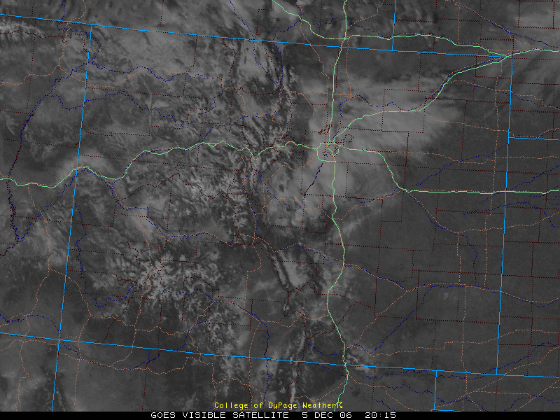
| This visible satellite
image from the
College of DuPage site shows the snowpack still over the entire
western part of Colorado. This image, valid at 2015Z 12/5,
corresponds to the high temperature of 25ºF,
roughly 20 degrees below the normal high due to the snowpack and
arctic air mass in place. |
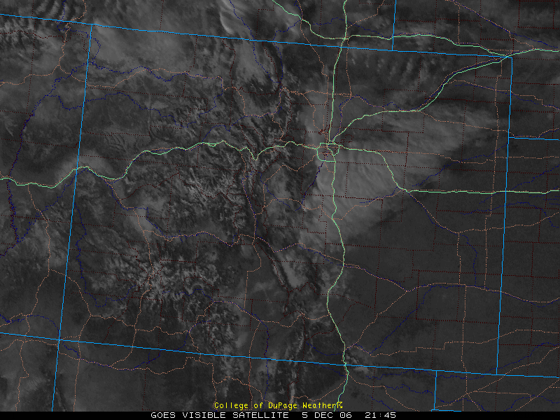
This visible satellite
image from the
College of DuPage site shows the snowpack at 2145Z 12/5.
Once again, this corresponds to the high temperature of 25ºF. |
The arctic air mass combined with the
snowpack kept the high and low temperatures considerably below normals.
Note the day's temperature spread and clear skies (forecast period only) on the
meteogram below.
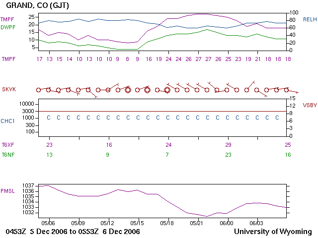 |
| This meteogram from the
University of Wyoming surface observations site shows the low of
8°F at 14Z and the high of 27°F at
21-22Z. The actual low of 7°F and actual high of 29°F occurred
in the vicinity of these hours. Note the clear skies and light
winds. What this meteogram can't show is the snowpack which
served to keep these temperatures considerably below normals. |
Back to Main Page