| |
| George R. Kasica
METEO 241 Portfolio #1: Remote Sensing as it relates to tropical cyclones The Wind Analysis
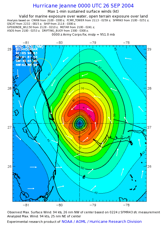
In this final portion of my look at Hurricane Jeanne I am going to examine briefly the wind analysis image. The above graphic is a wind analysis of Hurricane Jeanne from September 26, 2004 at 00Z shortly before it made landfall near Cocoa Beach Florida, and it is used to represent where and at what intensity the winds from a storm are occurring. In order to create this data item you can see that a large number of different sources were used: CMAN bouy and drifting buoy data, SFMR (Stepped Frequency Microwave Radar) data from the flight into the storm that we looked at earlier, QuickScat scatterometer data the we just finished looking at on the previous page, ocean vessel reports known as ship data, GPSSONDE data which again comes from the flight into the storm when thy actually drop instruments into the storm to obtain some of the readings we saw in the vortex data message, as well as the more normal METAR surface data and automated data reporting site (ASOS) reports. All of these various data sources are then combined and the graphic you see above is created from this data. In looking at the image you can see that given this more detailed set of data that the storm had just started to cause 40kt. winds to be felt in the area of Cocoa Beach and the Space Center (yellow circle on the image), however with this image you can see that the storm itself at the time had considerably higher winds that would soon come on shore there in a few hours, up to 90kts. in the NE portion of the storm that was heading straight for the Cocoa Beach area and would ultimately make landfall there in about 4 hours from the time this data was gathered (at about 04Z on September 26, 2004 - Midnight local time) with winds recorded at 105kts. near Stuart Florida. The last portion of my analysis of Hurricane Jeanne will offer some thoughts and reflections on the storm and what I learned in gathering the information.
Click the Next Button below to continue on
to my reelections on this assignment and the course so far, or to go
back to the scatterometer image page click the Previous Page button. To
return to the main page click the Home Button.
|