| |
| George R. Kasica
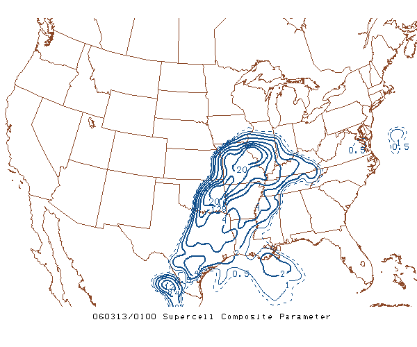
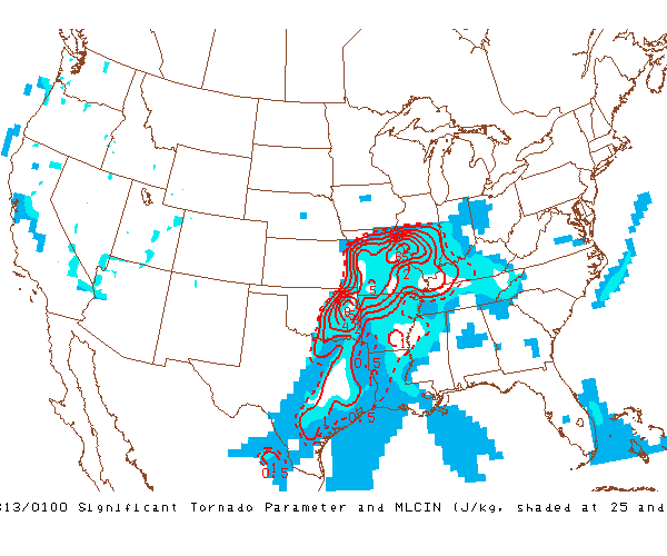
METEO 361 Portfolio #3: Supercell Tornadogenesis One of the final set of items that we can look at for the prediction of the formation of the supercells and tornadoes are the Supercell Composite Index from 7pm CST that evening and the Significant Tornado Parameter (Click on images for full size views).
In looking at the images we can see that the values in the area are near to 20 for the supercell values and between 5 and 6 for the Tornado Parameter. The SPC uses the following criteria for these parameters in forecasting severe weather and tornadoes:
Both of these values are what is known as composite indexes, in other words they are not values of just one particular atmospheric value, but a combination of several different items. The explanations of these is a bit more than the basic meteorology we have covered to this point but I will provide a brief explanation as well as links to fully detailed papers on each item. The Supercell Composite Parameter is a value that is obtained by combining the results of three different severe weather parameters: effective storm relative helicity, most unstable CAPE, and effective bulk shear. A complete detailed discussion of this index is available in this document taken from the Storm Prediction Center Web Site. The Significant Tornado Parameter is another composite value that is computed from a number of other values that includes effective bulk shear, effective storm relative helicity, 100-mb mean parcel CAPE, 100-mb mean parcel convective inhibition (CIN), and 100-mb mean parcel LCL height. Again a fully detailed discussion of this index is available in this document taken from the Storm Prediction Center Web Site. |