
JET STREAMS
As we take another look at the MD
(keep this window open throughout the project), the first paragraph
simply gives a synopsis of what to expect for the next few hours in a
way everybody can understand. Then, the rest of the
discussion goes into the meteorological details, in this case, starting
with the upper and low-level jets.
The MD starts by
describing the vertical motion associated with the nose of the 60 knot
low level jet. This jet is crucial for transporting moisture into
an area of developing precipitation about 5,000 ft. high, 850 mb. This map from the SPC archives on the evening of January 7 shows the strong winds over the Mid-Atlantic states at 850 mb moving toward the area.
Then, the MD says this area is ahead of a 150 knot upper level jet. The map below of 300 mb winds shows a jet streak moving
through the Ohio Valley and east into Canada. The image shows the
area of greatest winds, over 150 knots, moving east of Maine.
The right entrance region of this jet streak produced an area of
mass divergence over New England and New York, outlined in pink below.
This divergence along with the moisture from the low level jet helped precipitation advance into the area. This radar from UCAR illustrates this nicely.
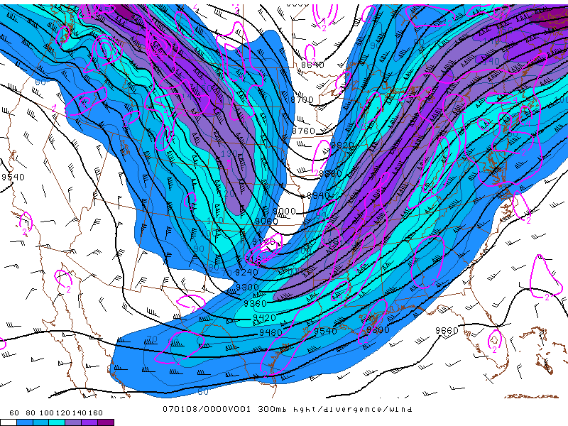
This image of 300 mb heights from 0100Z on January 8, 2007 shows
a potent jet streak moving through the Ohio valley and into eastern
Canada. This
jet streak produced mass divergence in its right
entrance region, outlined in pink, courtesy of SPC's Daily Archive Directory.
PAGE 1 2 3 4 5