
UPPER LEVEL ANALYSIS
Next, the MD says there's a fairly deep dry layer below 700 mb on
the Albany upper air sounding. The image below of the Albany
sounding on January 8 at 00Z shows the temperature and dewpoint going far
apart at 700 mb and remaining apart down to the surface. This is a sure
sign that any precipitation would initially evaporate before reaching
the ground. A reexamination of the 850 mb winds from the SPC archives indicates strong winds advecting moisture into the area which will saturate this layer within a couple hours, along with the falling precipitation.
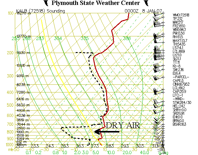
This is the 00Z sounding from January 8, 2007 which shows dry air below 700 mb. This causes precipitation to evaporate
before it reaches the ground, courtesy of Plymouth State Weather Center.
To further support the notion that precipitation in the MD area
will soon reach the ground, let's look at some observations to the
south, where the precipitation is coming from. These meteograms, courtesy of
Plymouth State, from Binghamton on January 7 and 8 show
precipitation falling from approximately 6,000 ft. shortly after the
ceilings were 10,000 ft., like the MD states. Also,
Williamsport's meteogram
shows rain falling from 5,000 ft. which is the same level as the 850 mb
winds, transporting moisture into the area. The image below,
showing temperature advection and winds at 850 mb, indicates winds as
high as 40 knots just to the south, meaning the precipitation will move
into the area at about that speed. Also, the warm advection means
that the snow may melt on the way to the ground, but it may refreeze on
contact, due to cold surface temperatures.
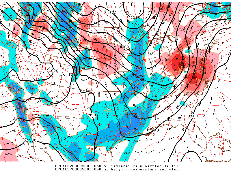
This is an image of 850 mb temperature advection, height,
temperature and wind from 0100Z on January 8, 2007 which shows the warmer
air and its
speed
moving into northern New York and northern New England, courtesy of SPC's Daily Archive Directory.
PAGE 1 2 3 4 5