This was my first experience in the
WxChallenge making a forecast with snow on the ground, and as a result, I
learned some new lessons. One thing I learned is that water vapor near the
earth's surface can be deposited on the snowpack, thus lowering the dew
point, which is probably what happened on the early morning of December
2. This series of METARS shows
the dew point was -6 C (22 F) at 00Z December 2 when I submitted my
forecast for the WxChallenge; therefore, if the temperature dropped to
within a few degrees of the dew point, I thought 25 degrees would be
a good low temperature forecast. However, the METARS show that by
09Z the dew point dropped to -9 C (16 F). With the lower dew
point, the temperature was able to drop further too, down to 21 degrees.
There was more, though, that enabled the temperature to drop as much as it did. I mentioned earlier that I didn't think the right conditions were in place for good net radiational cooling because of the tightening pressure gradient and increase in predicted wind speed on the MOS tables, but you can see on these METARS that the winds stayed around five knots for most of the night, allowing for much better net radiational cooling.
The reason the winds remained light was because there was a strong temperature inversion in place. If I had looked at this 24-hour forecast sounding from the ETA valid at 12Z December 2, I would have known the stronger winds above the surface wouldn't have been able to make it to the ground. The actual sounding from 09Z December 2, below, shows this strong inversion in place.
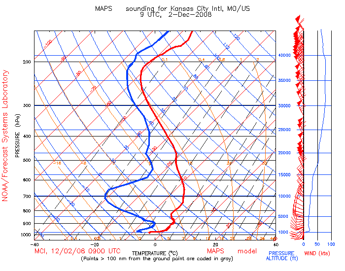
This is a skew-t diagram for Kansas City valid at 09Z December 2, 2008 that shows a strong temperature inversion in place over the
city which prevented high winds from getting to the surface, courtesy of MAPS/RUC Soundings.
1 2 3 4
There was more, though, that enabled the temperature to drop as much as it did. I mentioned earlier that I didn't think the right conditions were in place for good net radiational cooling because of the tightening pressure gradient and increase in predicted wind speed on the MOS tables, but you can see on these METARS that the winds stayed around five knots for most of the night, allowing for much better net radiational cooling.
The reason the winds remained light was because there was a strong temperature inversion in place. If I had looked at this 24-hour forecast sounding from the ETA valid at 12Z December 2, I would have known the stronger winds above the surface wouldn't have been able to make it to the ground. The actual sounding from 09Z December 2, below, shows this strong inversion in place.
This is a skew-t diagram for Kansas City valid at 09Z December 2, 2008 that shows a strong temperature inversion in place over the
city which prevented high winds from getting to the surface, courtesy of MAPS/RUC Soundings.
There's something else I didn't give enough consideration to when I made my low temperature forecast for December 2. During the cold season, MOS tends to forecast nighttime temperatures too warm at locations like Kansas City when there's a snow cover, skies are clear, winds are light and dew points are low because snow isn't climatological there, especially on December 2, unlike places further north. So, there were a couple things in place that should've made realize the temperature had the potential to really bottom out on the morning of December 2.
As you can see, I'm still learning a lot from every city in the WxChallenge. By participating in this contest, there's so much that I've learned from actually getting forecasting experience, as my previous e-portfolio assignments show. That's why I'd like to continue with the WxChallenge so my forecasts will keep improving.1 2 3 4