KANSAS CITY'S CLIMATOLOGY
Kansas City is located near the geographical center of the country in
northwest Missouri. The International Airport, just north of the
city where observations are taken for the WxChallenge, has an elevation
of approximately 1,000 feet. Kansas City's terrain is mostly flat
with only rolling hills, as you can see from the topographical map
below. Without mountains nearby, air can sweep in from different
directions, which determines the local weather.
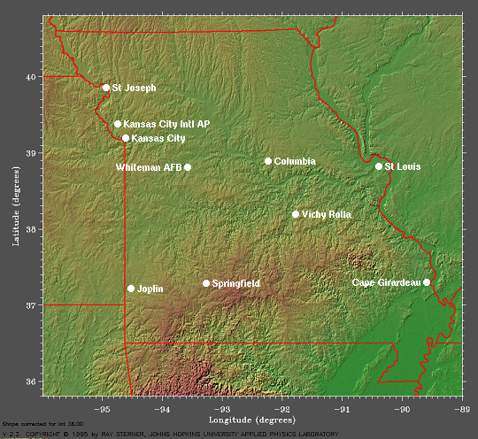
This is a topographical map which shows Kansas City's location in northwest Missouri, courtesy of
Earth System Research Laboratory (ESRL).
The wind rose below shows the predominant wind direction in
December is from the northwest and south. These southerly winds
occur on the backside of high pressure systems that are common across the
southeast, as you can see on this map of average sea-level pressure from 1968 to 1996 from ESRL. Also, they occur in advance of the many cold fronts that move
through during the winter months, while the northwest winds blow behind
these fronts and around high pressure over the Rockies. The average wind speed in December is approximately 10 knots.
Finally, the Local Climate Data for
the city shows that the record two-minute sustained wind speed for
December is 40 mph (35 knots). So, predicting a wind speed higher
than this is very bad forecasting.
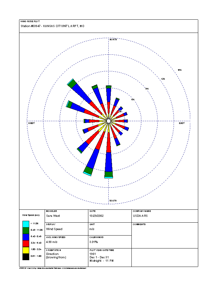
This is a wind rose plot, showing Kansas City's wind in December blows most often from the northwest and south, courtesy of
National Resources Conservation Service.
It will be a big advantage in the WxChallenge
to know the average temperatures and precipitation, as well as the
extremes. Here are
the Daily Almanacs in Kansas City for the contest period: December 2, December 3, December 4, December 5, December 9, December 10, December 11, and December 12.
From these Daily Almanacs, you can see the average high temperatures
range from 44 degrees on December 2 to 41 degrees on December 12; however, the record high
temperatures for this period can still get warm, as strong mid-latitude storms move west of the city. They range from
59 degrees to 74 degrees. This will help a lot in predicting what
the actuals will be. Also, it's important to know the lowest maximum
temperatures on record, which at this time of year varies from 10
degrees to 25 degrees. Now that it's December, arctic outbreaks that can cause these temperatures occur more frequently.
Also, the Daily Almanacs show the average low temperatures range from 27
degrees on December 2 to 23 degrees on December 12, but the record
lows get much colder from strong arctic highs settling over the area and providing good net radiational cooling.
They vary from 9 degrees to -5 degrees by December 9 and 12. Milder weather
still happens, though, as southerly winds blow ahead of cold fronts.
The highest minimum
temperatures in Kansas City range from 39 degrees to 57 degrees.
The winter is Kansas City's driest time of the year, as the average daily precipitation is only .06 inches, however, this record of rainfall extremes shows the daily precipitation has been as high as 2.82 inches on December 6 and as low as .29 inches on December 2.
Now, let's look at the big picture for Kansas City on December 2,
a day my low temperature forecast didn't turn out as well as I would've
liked.
1 2 3 4