MESOANALYSIS
Now that we've looked at the
synoptic scale environment responsible for the tornadoes, let's examine
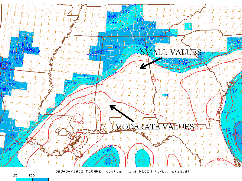
several key mesoscale features, first being MLCAPE, a way to assess how positively buoyant air parcels are, and MLCIN on the afternoon of April 4. Another way to look at CAPE on a skew-t is to find the area between the temperature profile and the lifted parcel. At 1900Z, the time of this image, thunderstorms
already moved through central Mississippi; therefore, values of MLCAPE
dropped here. However, these values were still around 1000 J/KG,
considered moderately unstable, over southern Mississippi and central
Alabama where the supercells were
now located. Also, the map shows no MLCIN in this area, so there
was nothing to stop these rapidly rising air parcels.
This is an image of 100mb MLCAPE/MLCIN from 1900Z on April 4,
2008, showing values near 1000 J/KG in the part of the tornado watch
where storms
were moving, courtesy of SPC's Mesoanalysis Graphics Page.
Vertical wind shear is
another critical factor for supercell tornadogenesis. It's
defined as the change in wind speed and or direction with height.
One of the best tools for predicting tornadic supercells is finding the
magnitude of the vertical wind shear between the ground and six
kilometers.
The image below of 0-6 km shear shows this value to be near 40
kts over the tornado watch and supercells typically form when wind
shear in the lowest six kilometers reaches 35-40 kts. Indeed,
there was a powerful supercell over central Alabama at this time with a
distinguishable velocity couplet which is indication of a mesocyclone that could lead to a tornado, as you can
see on this image of Doppler radar's storm relative motion.
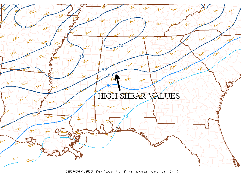
This is an image of 0-6km shear from 1900Z on April
4, 2008 which shows values around 40 kts in the area where supercells
were ongoing, courtesy of
SPC's Mesoanalysis Graphics Page.
Yet another important factor in predicting tornadoes is storm relative helicity (SRH). It's the rate at which an updraft ingests streamwise vorticity in
the boundary layer. According to the SPC, values of 0-1km SRH
that are greater than 100m2s-2 have an "increased threat of tornadoes with
supercells." From the image below, you can see that the supercell
I mentioned was approaching an area where the SRH in the lowest
kilometer was near 100m2s-2; therefore, a tornado was a distinct possibility.
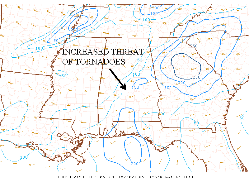
This is an image of 0-1km SRH at 1900Z on April 4, 2008 that
shows values near 100m2s-2 which increased the threat of tornadoes with
supercells,
courtesy of SPC's Mesoanalysis Graphics Page.
The high values of MLCAPE are directly related to the synoptic scale environment. Another look at the upper-air winds shows strong
winds at all levels along and colder temperatures. This provided strong dynamic lift. This colder
air aloft, along with the high theta-e values at the surface, created a
large temperature contrast that resulted in the instability necessary for severe
thunderstorms. All this made air parcels more positively buoyant because they're
warmer than their environment which created the rapidly rising air
parcels associated with high CAPE values. The stronger the updraft the more
intense these storms become.
Vertical wind shear depends on horizontal temperature gradients. This image of 500-mb heights
shows colder air moving into the tornado watch area associated with the
500-mb shortwave trough. The previous GFS image also shows this colder
air at other levels over the central Plains States. This
temperature gradient contributed to
the wind shear associated with 0-6 km shear and 0-1km SRH. Now,
everything was in place for the tornadic storms of April 4.
PAGE 1 2 3 4 5