
RASMUSSEN TECHNIQUE
Once supercells form, it's crucial for the public's safety to find out where they will be
headed. At first, they move with the mean cloud-layer wind;
however, as supercells intensify, they take a turn to the right.
Here's a radar loop showing
the motion of the various supercells and their associated
tornado warnings in the red boxes on the afternoon of April 4. As
you can see, many of the thunderstorms are moving northeast; however, as they
strengthen, they turn more to the east or
slightly north of east.
The Rasmussen Technique serves as a guide for us to predict the motion of these right-moving storms. The image below is a diagram I drew on a hodograph demonstrating this technique using information I got from this sounding
from Jackson, Mississippi just prior to these supercells. First,
plot the wind speed between the ground and 500 meters, just under 10
kts, and then at four kilometers, 45 kts. Then, draw the shear
vector between these two points. After that, locate the point
that lies 60% of the distance between the tail and the arrowhead and
from there draw a line representing 17 kts at a 90 degree angle.
Last, draw a line between the origin and the end point of the
previous line segment. This line represents the approximate
motion of these right-moving storms on April 4 using the Rasmussen Technique. In this case, the storm
motion vector is 25535, meaning that the supercells should move from
the west-southwest at 255 degrees at about 35 knots. This
matches up well with the previous radar loop.
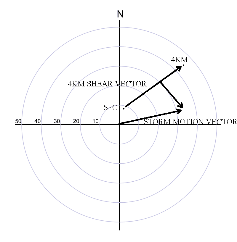
This is a diagram representing the Rasmussen Technique. It
predicted the storm motion for the right-moving supercells on the
afternoon of April 4,
2008. In this case, the motion was from the west-southwest at 255 degrees at 35 knots.
Even though some of the mesoscale analysis I documented were only
marginally unstable for tornado producing supercells, for example MLCAPE and 0-1km SRH,
the surface and upper-air parameters worked together to make for a
sizeable outbreak; therefore, there were 14 reports of tornadoes
on April 4, mostly in the watch area from central Mississippi to
central Alabama. Obviously, the SPC was right on target in
issuing this tornado watch. With so many variables to examine before issuing these watches, it's amazing how often they're right.
PAGE 1 2 3 4 5