EASTERLY WAVE


Hurricane Frances formed from what meteorologists call an easterly wave.  Between the months of June and October, these
waves emerge off the coast of Africa and move west across the tropical Atlantic.  Many of these easterly waves are quite
vigorous as they leave the African coast, about every three to four days; however, most of them lose some of their punch
over the ocean due to a more stable environment.  Therefore, only about one in ten of these waves turn a storm somewhere
over the Atlantic, but, as you will see, Frances was one that did.

On August 21, a wave of low pressure emerged
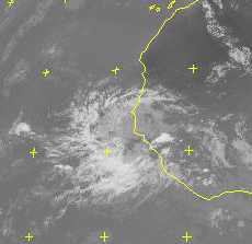
from the west coast of Africa.  The infrared satellite image to the right shows a healthy area of showers
and thunderstorms just off the coast which served
as the seedling circulation for what would later
become Hurricane Frances.  Even at this early
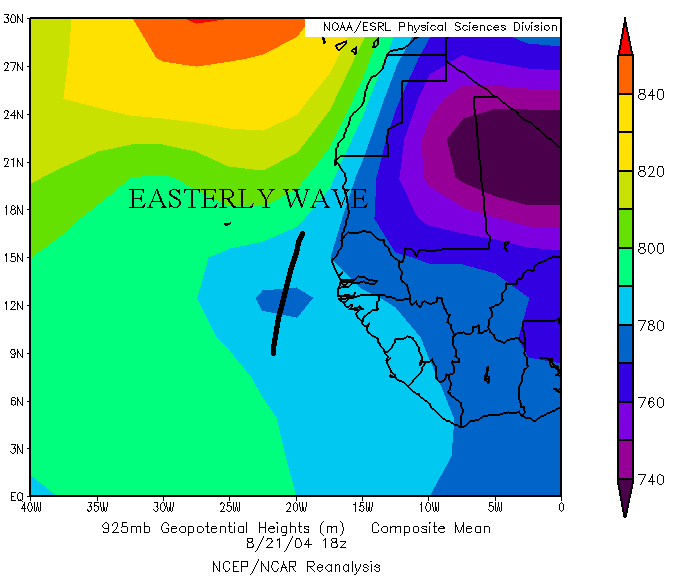
stage, there was already a closed height contour
at 925 mb, depicting an area of low pressure, as
seen in the image below.  There are signs that the         storm was already showing some organization, by
the cyclonic curvature to the clouds and the upper       level outflow. Frances was off to a well developed       start, but there are certainly many more things that
go into the formation of a strong storm which I'll
delve into next.


                                                                                                                                       This is a satellite image from August 21 at 18Z that shows an area of convection 
                                                                                                                                       off the coast of Africa that would later become Frances, courtesy of SATMOS.


This is an image of 925 mb heights from August 21 at 18Z that shows an easterly wave just west of Africa that
provided the seedling circulation for Hurricane Frances, courtesy of ESRL.


PAGE     1    2    3    4    5    6