EYEWALL DYNAMICS

Once hurricanes become intense, studying its eyewall becomes very fascinating.  In these kinds of storms, the eyewall will
undergo changes, for instance eyewall expansion and contraction.  Another interesting thing that can happen is one eyewall can
be replaced by a new larger eyewall, called an eyewall replacement cycle.  All these things can have an effect on a storm's
strength and Hurricane Frances was no different.

When the ring of thunderstorms in a hurricane's eyewall shrinks, an eyewall contraction cycle is occurring.  When this happens
the radius of maximum wind speed decreases.  In order to conserve angular momentum, the tangential wind speed increases.
Obviously, the storm strengthens at this time; however, when the eyewall expands, an eyewall expansion cycle, the opposite
occurs.

An eyewall replacement cycle happens when an outer rainband spirals inward and forms a new ring of thunderstorms around the
inner eyewall.  This outer wall limits the inner eyewall's access to moisture because convergence occurs, as well, around the             outer-ring of storms.  Also, the subsidence around the outer wall enhances the dry air that's ingested into the thunderstorms of
the inner eyewall.  As the new, larger eyewall takes over, the hurricane weakens because the radius of maximum wind speed             increases, as a result the tangential wind speed decreases.

There's a fascinating new way to look at Hurricane Frances'
eyewall dynamics, as well as others, called MIMIC which stands for Morphed Integrated Microwave Imagery at CIMSS.  It uses successive microwave images to create an animation that lets meteorologists further investigate a hurricane's eyewall.  For example, this MIMIC animation of Frances from August 30
shows the storm undergoing an eyewall replacement cycle.  On these animations, the yellows and reds represent the strongest thunderstorms, and in the case of Frances, you can see a second, larger eyewall form around the inner eyewall.  As I mentioned, once this occurs, hurricanes usually weaken which Frances did. During this cycle, Frances went from a Category 4 storm with winds of 130 mph just prior to this animation to a Category 3 with 115 mph winds at the end of this animation, as this storm history shows.
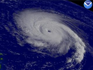
                                                                                                    This is a satellite image of Hurricane Frances from August 30 at 1215Z. At  this time it was
                                                                                                                                                              undergoing an eyewall replacement cycle, undetectable by satellite, courtesy of NOAA.

As I've explained, conditions must be nearly perfect for major hurricanes to develop, everything from sea surface temperatures
to vertical wind shear just to to name a few.  Once everything's in place, residents from Massachusetts to Central America,
including the Caribbean, hold their breath to make sure their town isn't the next that's hit, as the big Bermuda High steers these
storms across the Atlantic.  Unfortunately for Florida, their state was the target for Frances and many other storms in the terrible
summer of 2004.


PAGE    1    2    3    4    5    6