PRIME CONDITIONS

After this easterly wave left Africa and continued moving west over the tropical Atlantic, it started to gain strength, due to
some very favorable conditions, sea surface temperatures being one of them.  This plays an integral part in the formation of  
hurricanes.  Why is this so important?  These storms are driven by high evaporation rates which increase as sea surface
temperatures increase.  Generally, meteorologists look for these temperatures to be at least 26 degrees Celsius (80F).  Once
this temperature is achieved, the air over the ocean becomes unstable enough for development to continue.  The image of sea
surface temperatures below at the time of Frances formed into a hurricane shows water temperatures above the 26 degree
threshold, meaning development should continue.


This is an image of sea surface temperatures from August 22 to 26 just prior to Frances becoming a hurricane.  It shows the storm 
moved across an area where the ocean was above 26C to support tropical development, courtesy of ESRL.

Another condition necessary for tropical waves to develop into hurricanes is high mid-tropospheric relative humidity.  If dry
air gets entrained into the thunderstorms of a hurricane, it causes evaporational cooling.  This causes downdrafts in the
thunderstorm to bring drier, more stable air into the boundary layer.  Now that lower theta-e air has been brought into the
storm, it diminishes the chance of new convection forming.  This image, courtesy of PSU, shows this process well; therefore,
high relative humidity, also, is essential for development.  

The water vapor image to the right, showing mid-tropospheric relative humidity on the day Frances became a hurricane, shows
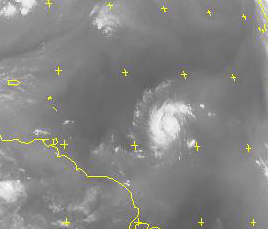
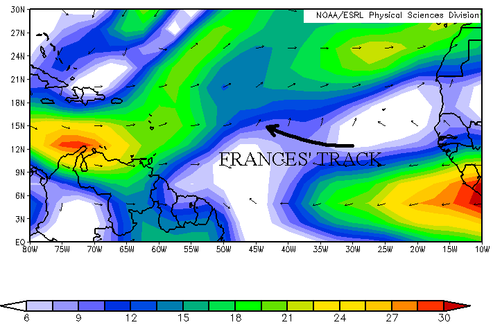
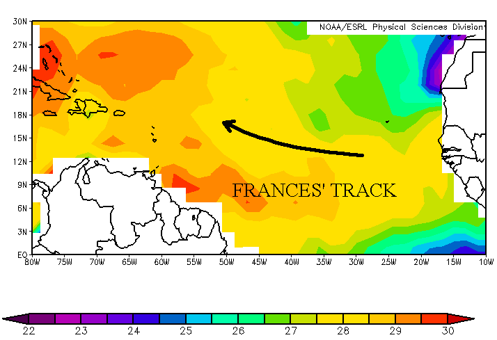
the lighter colors near and to the east of the storm representing
higher levels of moisture.  Also, the darker colors north of the
storm represent much drier air.  If Frances moved into this environment, dry air entrainment would soon begin, choking the storm.  Instead, it stayed on a track more to the west into an environment where the moisture was high enough for continued growth.  


                                                                                                                           This is a water vapor image from August 26 at 12Z.  It shows high levels of 
                                                                                                                                                                    
humidity around the storm and dry air to the north, courtesy of SATMOS.
                                                                                                                                                                                                                                       
Vertical wind shear is one more variable that's crucial for a hurricane's development.  It's defined as the change in wind speed
and/or direction with increasing altitude.  If the vertical wind shear is strong enough, it will blow the thunderstorms away from
the center of the storm which in turn disrupts the upward motion that's necessary for a hurricane to intensify.  Generally, wind
shear with a westerly component is most harmful to these storms in the northern hemisphere because most of them are moving
to the west against this wind.

What amount of wind shear is acceptable for hurricanes to intensify?  Usually, any value under 10 meters per second is low
enough for a developing storm to survive, especially if the wind has an easterly component.  The image below is the wind shear
and direction just prior to when Frances became a hurricane at the 850 mb to 200 mb level, where wind shear measurements are
most commonly taken.  It shows that Frances, indeed, moved through an area where the shear wasn't from the west and under  
10m/s, allowing the storm to strengthen.  Now that all the conditions were in place for Frances to grow, we'll take a look at the
storm as a major hurricane.


This is an image of vertical wind shear in the 850 mb to 200 mb level from August 25 to August 26, just prior to Frances becoming a
hurricane.  It shows that Frances moved through an area with relatively low wind shear which allowed it to strengthen, courtesy of ESRL.


PAGE    1    2    3    4     5     6