LESSONS LEARNED
Because I didn't take everything into consideration on my
October 9 forecast, there's quite a bit I learned from this day.
One important lesson I learned is I need to examine all the different mesoscale analyses when forecasting
precipitation associated with thunderstorms. As you remember, I
paid more attention to the 500-mb vortmax and low-level jet stream;
however, if I had looked at all the parameters such as CAPE and lapse
rates, among others, I would have realized thunderstorms weren't a
certainty. Again, I forecasted .55 inches when
no rain fell.
The CAPE values in Jacksonville on October 9 were not all
that high. The image, below, of MLCAPE and MLCIN valid at 18Z
October 9 shows that the MLCAPE values were only about 1,000 Joules
per Kilogram. This value is just approaching the threshold of
being moderately unstable. You can see the higher values over
2,000 J/K further south in the state. Also, there was some MLCIN
over Jacksonville and to the north. Similarly, this image of low level lapse rates from the SPC valid at the same time shows higher values to the south, as well.
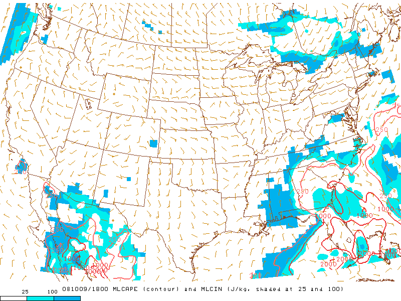
This is an image of MLCAPE and MLCIN valid at
18Z October 9 which shows moderate values of MLCAPE approaching the
Jacksonville area,
courtesy of the Storm Prediction Center.
These values correspond well with the radar image from the afternoon of
October 9, below, showing that storms
did erupt around the Jacksonville area, but the most intense storms
were to the south with the more unstable air. Therefore, it
wasn't a solid line that
would've given the airport the rain I had hoped. This series of
METARS indicates a gust front moved through as the storms moved by to the south,
as you can see from the dramatic drop in temperature and rise in wind speed.
Ultimately, this prevented any more storms from forming, by reducing the necessary heat and instability.
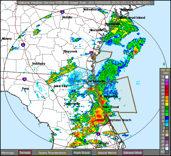
This is a radar image valid at 2035Z on October 9 that shows showers and thunderstorms around the Jacksonville
area, courtesy of the National Weather Service.
Due to the differing mesoscale analyses, I
should've known thunderstorms were only a possibility for Jacksonville.
In the end, this forecast knocked me out of the top 50 in the
forecast
standings for Jacksonville in the WxChallenge; however, I was still very
happy with being in the top 10 percent. Next, I'll discuss a
busted forecast I made for Casper, Wyoming, but first I'll start with their
climatology.
1 2 3 4 5 6 7