

Not surprisingly, Jacksonville’s proximity to the Atlantic Ocean helps to temper afternoon temperatures during the warm season as faithful sea breezes press inland. The visible satellite image below (1945Z on August 29, 2008) shows a line of cumuliform clouds over northeast Florida and southeast Georgia that mark the sea-breeze front (note the strip of clear, relatively stable, maritime air along the coast). Keep in mind that the overall synoptic-scale pressure gradient must be relatively weak in order for the sea breeze to develop. Check out the 21Z surface analysis on August 28, and note the relaxed PGF over the Southeast States and adjacent Atlantic waters.
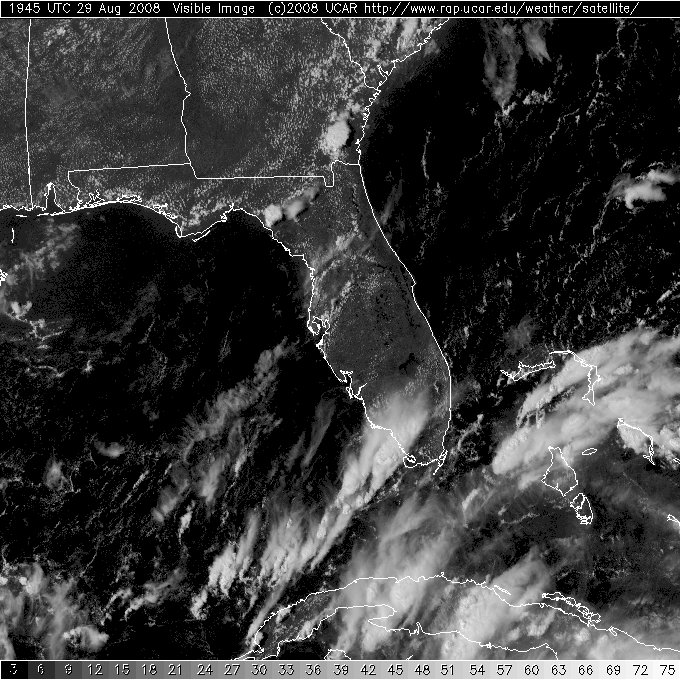
A visible satellite image at 1945Z on August 29, 2008,
shows cumuliform clouds along the sea-breeze front pressing inland across
northeast Florida and southeast Georgia, courtesy of the University Center for Atmospheric Research.
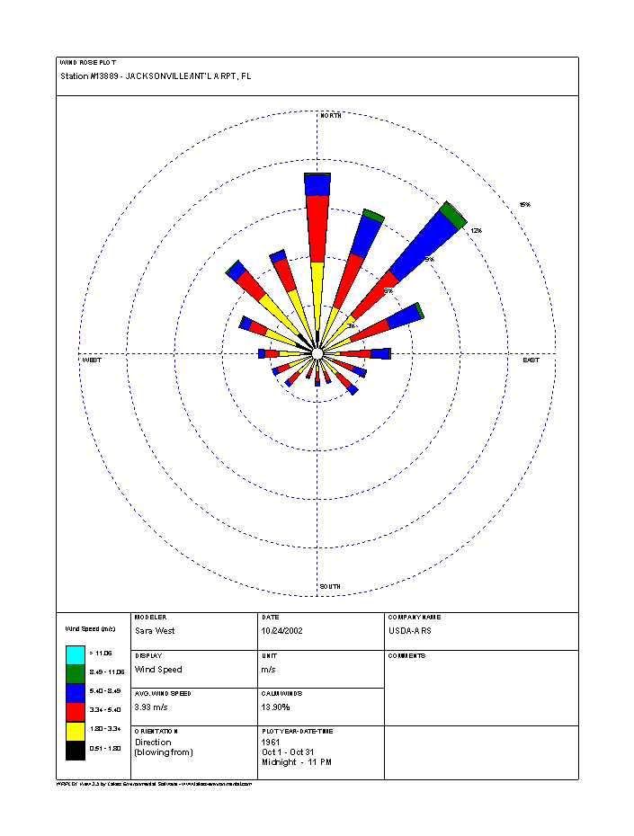
Given the prominence of the sea breeze during the warm season, the prevailing winds at Jacksonville are generally northeasterly (check out the October wind rose below); however, as we move later into October, cooler air from the north begins moving into Jacksonville. Note the high frequency of surface winds blowing from the north, as well. The clockwise circulation of air around transient high-pressure systems passing to the north of Jacksonville also helps to contribute to the “popularity” of northeasterly and northerly winds (particularly later in the month). Included in the text data listed below the wind rose is the average wind speed during October ... 3.93 meters per second, which converts to approximately 8 knots.
The October wind rose at Jacksonville's International Airport, courtesy of National Resources Conservation Service.
The Local Climate Data for Jacksonville indicates that the record two-minute sustained wind speed at Jacksonville during October is 31 miles an hour (27 knots). For the record, all WxChallenge wind speeds are two-minute averages expressed in knots (same convention for METAR observations).
Before I delve into normals (averages) and extremes in temperature and precipitation, check out the Daily Almanacs for Jacksonville during the WxChallenge: September 30, October 1, October 2, October 3, October 7, October 8, October 9 and October 10. By examining these Daily Almanacs, you can see that the average high temperature drops from 83 degrees at the start of the period to 80 degrees at the end. Having these statistics in the back of your mind is always prudent ... at the very least, knowing that climatology is one of the MOS temperature predictors puts you in a more advantageous position. Shifting from averages to extremes, please note that the record high temperatures for this period are, chronologically, 94 degrees, 94 degrees, 93 degrees, 92 degrees 95 degrees, 93 degrees, 94 degrees and 92 degrees. Surprised that they’re so low? Oh the moderating power of the Atlantic Ocean!
As a good forecaster, you should also be aware of the lowest daily maximum temperatures. From the NOWData on Jacksonville’s Climate page, you can see that lowest maximum temperatures on record vary from 62 degrees to 72 degrees during this time period. Typically, cloudy, rainy days tend to be the kind of days when low-max temperature records are set in Florida during the warm season, although the arrival of cooler air masses from the north can also contribute to noticeably low daytime temperatures.
From the Daily Almanacs, I point out that the average daily low temperatures fall from 65 degrees to 62 degrees. Shifting to extremes, the record low temperatures range from 44 degrees to 51 degrees for this period. Clearly, early October is a time when cooler, drier air masses become a part of the weather pattern at Jacksonville. For the record, the record highest minimum temperatures during this period (from NOWData) vary from 74 degrees to 78 degrees. Obviously, tropical air still stakes a claim to Florida in early October!
Finally, from the Daily Almanacs, the average daily rainfall drops from 0.21 inches at the start of the period to 0.14 inches at the end of the period. By and large, I think it’s fair to say that a share of the rainfall during this period comes from thunderstorms associated with the sea breeze. But, and this is a big “but,” these daily averages are likely inflated from heavy rain associated with passing tropical cyclones and easterly waves. The record daily rainfalls for the period vary from 1.69 inches on October 9 to 7.83 inches on October 3.
Thanks to Lee Grenci for helping with this climatology. Now, let's look at the synoptic-scale weather pattern on one of the days my forecast busted.