
Now that we've looked at the synoptic-scale features responsible for this outbreak, let's examine several key mesoscale features, first being the equivalent potential temperature, also called theta-e. It's defined as the temperature an air parcel would attain if it was lifted until it became saturated, further lifted until its water vapor condensed and brought back down dry adiabatically to 1000 mb, usually expressed in Kelvins. Basically, theta-e is a way to detect the destabilizing effects of low-level heat and humidity; the higher the value, the more moisture that's available for thunderstorms.
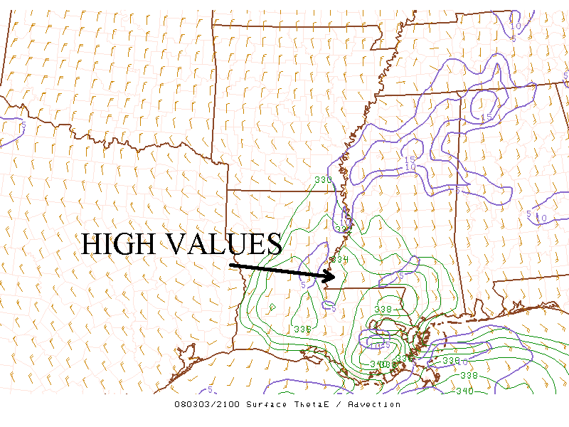
This is an image of theta-e temperatures from 2100Z on March 3, 2008. It shows values over 330 K which helped contribute to the formation of
thunderstorms, courtesy of SPC's Mesoanalysis Page.
On March 3, theta-e values were high over Louisiana and southern Mississippi. Another look at the temperatures and dew points from that afternoon indicates high levels of warmth and humidity over the area that resulted in the image above of theta-e temperatures. Values over 330 K which the image shows over Louisiana and southern Mississippi are sufficiently high for surface based convection to form. This surface based convection typically leads to high winds and tornadoes, as this corresponds well with the previous image of storm reports. Also, the sounding below from Slidell, Louisiana shows there was no inversion near the ground, so the convection would, indeed, be surface based. In addition, it shows sufficient wind shear for tornadoes to form.
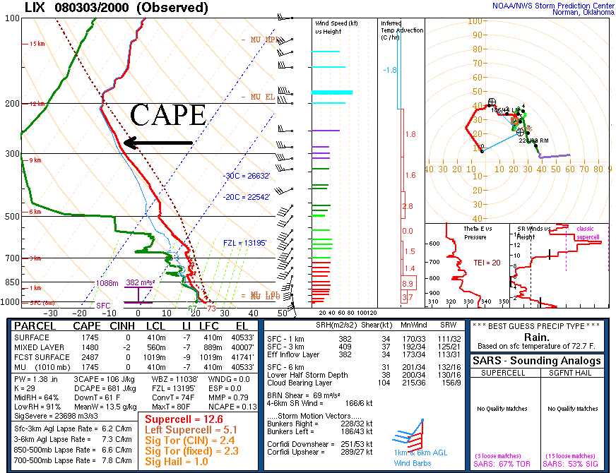
This is a skew-t plot from Slidell, Louisiana from 2000Z on March 3, 2008 which shows the lack of an inversion near the surface, CAPE, as well as, ample wind shear,
courtesy of SPC soundings.
Another way to assess the possibility of thunderstorms is by looking at values of Convective Available Potential Energy (CAPE). On a skew-t, CAPE is found by looking at the area between the temperature and the lifted parcel, above. Sometimes values of SBCAPE are inflated, though, giving forecasters an inaccurate look into a storm's potential; therefore, MLCAPE is a fairer way to assess the values of CAPE, provided the lowest layers of the boundary layer are well mixed. Indeed, this is the case, as the skew-t above shows. This map below shows MLCAPE over southwest Mississippi and most of Louisiana over 1000 J/kg which is considered moderately unstable for the eruption of thunderstorms, while there was virtually no Convective Inhibition (CIN). This offered little resistance to the rapidly rising air parcels.
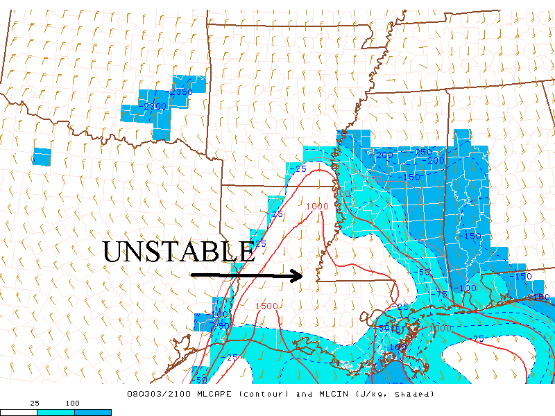
This is an image of MLCAPE/MLCIN from 2100Z on March 3, 2008 which shows enough CAPE and very little CIN for the formation of thunderstorms,
courtesy of SPC's Mesoanalysis Page.
It's clear that the synoptic and upper-air patterns created an environment favorable for high theta-e and MLCAPE. Let's take another look at the surface map from March 3. There were strong southerly winds from the counter-clockwise flow around the low pressure system in Arkansas. These winds brought up temperatures in the 70's and dew points in the 60's from the Gulf of Mexico, as you recall from the maps above. This warmth and humidity resulted in the high theta-e values observed where the storms broke out.
As for the high MLCAPE values, a reexamination of the upper-air winds shows powerful winds at all levels which provided strong dynamic lift in the troposphere. You can see, as well, colder temperatures at these levels. This colder air aloft, along with the high theta-e values at the surface, created a large temperature contrast that resulted in the instability necessary for severe thunderstorms. All this made air parcels more positively buoyant because they're warmer than their environment which paved the way for the rapidly rising air parcels associated with high CAPE values. The stronger the updraft the more intense these storms become which is what happened on March 3.
PAGE 1 2 3 4 5