Doppler radar
is the best way to detect a dangerous thunderstorm. Although
Doppler radar rarely sees an actual tornado, it can detect a storm's mesocyclone which can house a tornado. The
picture below is an image of Doppler radar's storm relative motion.
The red colors are winds moving away from the radar site and the
green colors are winds moving toward the radar site. The tight
proximity of inbound and outbound velocities in the image below is
known as a velocity couplet which is an indication of a mesocyclone.
After looking at this radar image from the NWS of a supercell and the image below of a velocity couplet, the National Weather Service issued this tornado warning,
saying this storm is capable of producing a tornado. Even though
I don't think a tornado actually touched the ground in this case, after
looking at the image of storm reports, it just as easily could have happened.
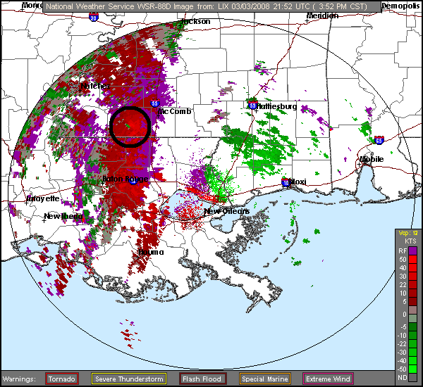
This is an image of storm relative motion taken at 2152Z on March 3, 2008. It shows the signature of a
mesocyclone which is capable of producing a tornado, courtesy of NWS.
With all the surface and upper-air support I discussed, it's surprising there weren't a few more tornadoes in this outbreak, especially after the record setting month of February. Luckily for the storm weary southeast, this wasn't the case, possibly because the upper-level dynamics and the lower-tropospheric instability never quite merged. It just goes to show that no matter how minor or major a storm system looks, forecasters always have to be on top of their game when predicting severe thunderstorms.
PAGE 1 2 3 4 5