
QUILLAYUTE'S CLIMATOLOGY
Quillayute, Washington is located on the coastal plain between the Pacific Ocean
and the Olympic Mountains, only three miles from the coast. The terrain
gradually increases from the coast to an elevation of 180 feet at the
reporting station for the WxChallenge, the Quillayute Airport.
The topographical map below shows Quillayute's location and
proximity to the coast.
In Quillayute, the maritime air from the Pacific affects the climate throughout the
year. By November, low pressure systems in the Gulf of Alaska
intensify and move south, bringing in storm systems at frequent
intervals. The area averages of over 100
inches of rain per year. As a result, there is little diurnal or day-to-day change in
temperature, especially in November. Only large high pressure systems bring an extended break from the rain.
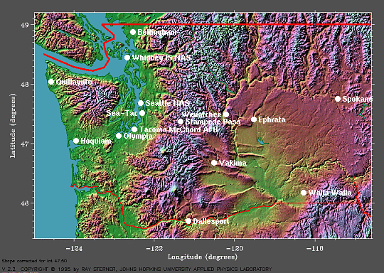
This is a topographical map of Washington which shows Quillayute's proximity to the Pacific Ocean,
courtesy of Earth System Research Laboratory (ESRL).
Even though the winds aloft are often from the west and southwest
in November which bring in the Pacific moisture, the winds at the
surface are a different story. The wind rose plot below shows
most of the surface winds are from the east and southeast in November
because of low pressure and associated pressure falls in the Gulf of
Alaska and high pressure and associated pressure rises over the Great
Basin. You can see these highs and lows on this map of average sea-level pressure from 1968 to 1996 from ESRL. However, the northeast winds come from high pressure further north over western Canada.
The Local Climate Data for
Quillayute shows that the record two-minute sustained wind speed for
November is 37 mph (32 knots), but I'm sure normally it's much less. The average wind speed for Quillayute in
November is only 4.6 m/s (9 knots).
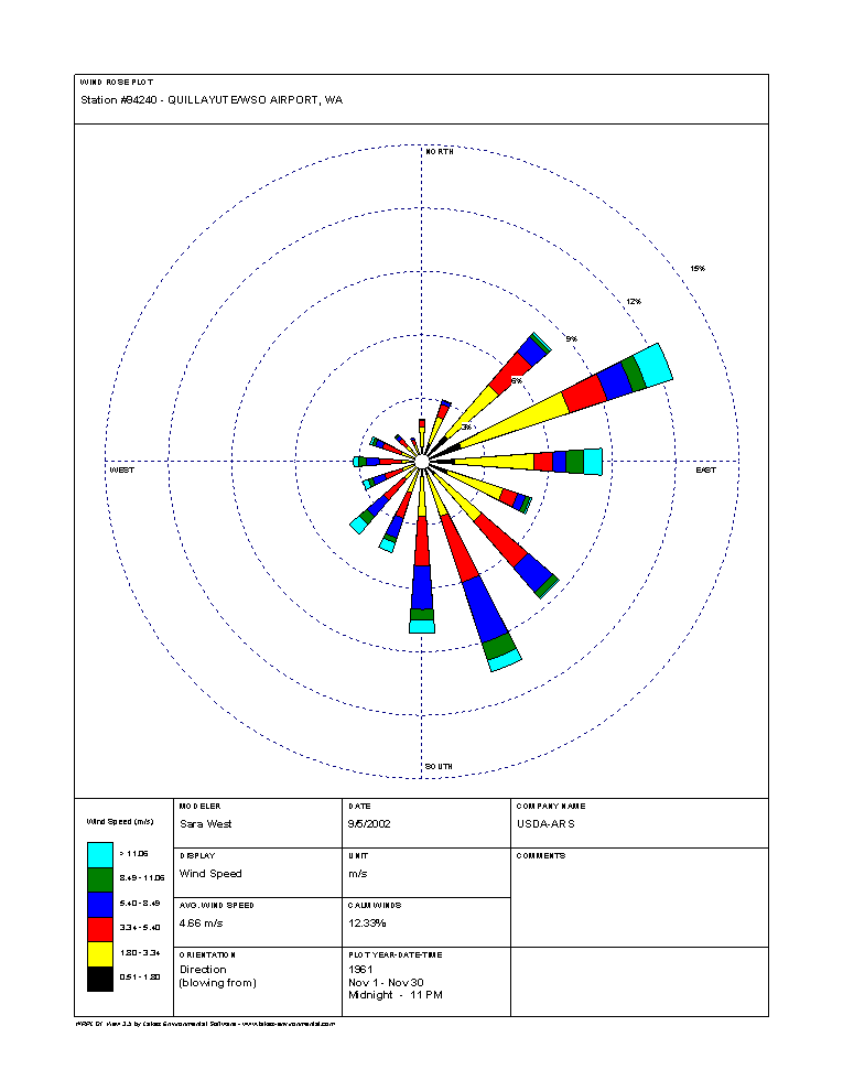
This is a wind rose plot, showing Quillayute's wind in November blows mostly from the east and southeast, courtesy of National Resources
Conservation Service.
It will help greatly in the WxChallenge to know the average temperatures and precipitation, as well as the
extremes. Here are
the Daily Almanacs for Quillayute during the contest period: November 11, November 12, November 13, November 14, November 18, November 19, November 20 and November 21.
From these Daily Almanacs, you can see the average high temperatures
range from 52 degrees on November 11 to 50 degrees on November 21 and the record high
temperatures for this period range from 56 degrees to 66 degrees.
These temperatures will guide me significantly in predicting what
the actuals will be.
Also, it's important to know the lowest maximum
temperatures on record, which at this time of year vary from 31
degrees to 47 degrees. These would most likely occur as arctic highs move south from Canada.
The Daily Almanacs show the average low temperatures only
range from 38
degrees on November 11 to 37 degrees on November 21, and the
record
lows don't change that much either. They vary from 19 degrees to 26
degrees at this
time, again as cold, dry air moves south from Canada. The highest minimum
temperatures in Quillayute range from 46 degrees to 55 degrees, as mild
Pacific air can make the air a little warmer on occasion at
night.
As I said, the rainfall in November is
extraordinarily high. The average daily precipitation ranges from
a whopping .49
inches on November 11 to .52 inches on November 21, from storm after
storm plowing into the Washington coast from the gulf of Alaska.
Finally, the rainfall records can get really wild, ranging from 1.57 inches on November 16 to 5.28 on November 19.
Now, let's examine the big picture for Quillayute on November 12, when my low temperature forecast busted.
1 2 3 4 5 6 7